Download
1 / 35
380 likes | 581 Vues
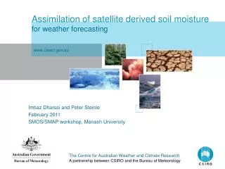
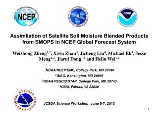
Assimilation of Satellite Soil Moisture Blended Products from SMOPS in NCEP Global Forecast System Weizhong Zheng 1,2 , Xiwu Zhan 3 , Jicheng Liu 4 , Michael Ek 1 , Jesse Meng 1,2 , Jiarui Dong 1,2 and Helin Wei 1,2 1 NOAA/NCEP/EMC, College Park, MD 20740 2 IMSG, Kensington, MD 20895

E N D
Assimilation of Satellite Soil Moisture Blended Products from SMOPS in NCEP Global Forecast System Weizhong Zheng1,2, Xiwu Zhan3, Jicheng Liu4, Michael Ek1, Jesse Meng1,2, Jiarui Dong1,2 and Helin Wei1,2 1NOAA/NCEP/EMC, College Park, MD 20740 2IMSG, Kensington, MD 20895 3NOAA/NESDIS/STAR, College Park, MD 20740 4GMU, Fairfax, VA 22030 JCSDA Science Workshop, June 5-7, 2013
OUTLINE: • Objective • Embed EnKF in GFS • Testing with SMOS SM • Testing with SMOPS Blended SM * Fits to SfcObs * Fits to RaObs * Scores * CONUS Precipitation • Summary and future plan
OBJECTIVES • “Online” satellite soil moisture data assimilation in NCEP GFS • Examine how satellite SM data impact NCEP GFS forecasts
NOAA NESDIS Soil Moisture Operational Product System (SMOPS) • 6-hour operational soil moisture product from the Office of Satellite and Product Operations (OSPO) of NOAA/NESDIS. • Carries near real-time global gridded soil moisture products from several individual satellite sensors as well as a blended product. • Soil moisture layer from individual sensors: (AMSR-E), ASCAT, SMOS, and WindSat. • Blended product: CDF matching is used to merge all available values from above individual sensors to a common climatology, resulting in better spatial and temporal coverage.
SMOPS Blended Product from WindSat, SMOS and ASCAT ASCAT SMOS WindSat Blended
Testing with SMOS SM (May 1 – June 17 2012): 18Z, 1-17 June 2012 SMOS GFS_CTL GFS_EnKF EnKF-CTL
Testing with SMOS SM (May 1 – June 17 2012): 18Z, 1-17 June 2012 SMOS GFS_CTL EnKF-CTL GFS_EnKF
Assimilation of Satellite Soil Moisture Blended Products from SMOPS in NCEP Global Forecast System • The simplified ensemble Kalman Filter (EnKF) was embedded in the GFS latest version to assimilate soil moisture observation. • Case: Starting from 00Z April 1–May 4, 2012. (GFS/GSI) • Experiments: CTL: Control run (without SM DA) EnKF: Sensitivity run (Daily EnKF run) And precipitation perturbation. PRT: Perturbation size for each layer soil moisture.
Comparison of soil moisture from SMOPS Blended 18Z, 1-30 April 2012 SMOPS GFS_CTL GFS_EnKF EnKF-CTL
Comparison of soil moisture from SMOPS Blended 18Z, 1-30 April 2012 SMOPS GFS_CTL EnKF-CTL GFS_EnKF
GFS Top Layer SM Validation With USDA-SCAN Measurements 1-30 of April, 2012
Soil moisture at 4 layers: Day 3: April 2 – May 4 2012 CTL SM1 SM2 Diff SM3 SM4
Q2m (left) and T2m (right): Day 3: April 2 – May 4 2012 CTL Diff
Tmin2m (left) and Tmax2m (right): Day 3: April 2 – May 4 2012 CTL Diff
Sfc RH (%) over CONUS West and East: April 2 – May 4 2012 East West
Sfc RH (%) RMSE over CONUS West and East: April 2 – May 4 2012 East West
Sfc T (K) over CONUS West and East: April 2 – May 4 2012 East West
Sfc T (K) RMSE over CONUS West and East: April 2 – May 4 2012 East West
RH (%) Bias and RMSE over CONUS: Day 5: April 2 – May 4 2012 RMSE Bias
T(K) Bias and RMSE over CONUS: Day 5: April 2 – May 4 2012 RMSE Bias
700 hPa + 0.003 1000 hPa + 0.003
Bias - 0.36 RMSE - 0.43
Bias RMSE
NHX + 0.002 SHX + 0.007
NHX SHX
Summary: The satellite soil moisture blended products from SMOPS were assimilated in NCEP GFS and the result shows as follows: 1) Improved GFS deeper layer soil moisture estimates comparing with in situ measurements; 2) Improved GFS forecast scores and reduced its bias and root-mean-square errors. 3) Showed some positive impact on precipitation on CONUS but not for heavy precipitation. Future: assimilate SMAP (remote sensing), COSMOS & other in situ measurements. Furthermore, consider regions where soil alternates (frozen and thawed) during the transition seasons (by CREST ongoing project).
Thank you! Questions?