Floodplain mapping using soil data, ssurgo
CE 549 Computational Watershed Hydrology Jonghun Kam Instructor: Professor Venkatesh Merwade. Floodplain mapping using soil data, ssurgo. Methodology. From soilmu_a_in157. From mapunit.txt in in157/tabular folder. From: www.floodsafety.com. Study areas: Indiana. From SSURGO. From FEMA.


Floodplain mapping using soil data, ssurgo
E N D
Presentation Transcript
CE 549 Computational Watershed Hydrology Jonghun Kam Instructor: Professor Venkatesh Merwade Floodplain mapping using soil data, ssurgo
Methodology From soilmu_a_in157 From mapunit.txt in in157/tabular folder From: www.floodsafety.com
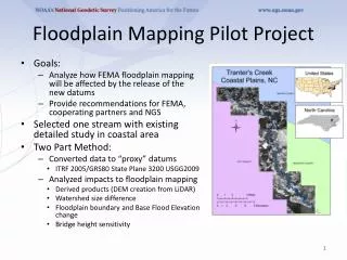
Study areas: Indiana From SSURGO From FEMA
Study Area: Texas From SSURGO From FEMA
Topographic Wetness Index (TWI) • Based on the assumption that topography controls the movement of water in slopes terrain, TWI can quantify the control of local topography on hydrological processes and indicate the spatial distribution of soil moisture and surface saturation.