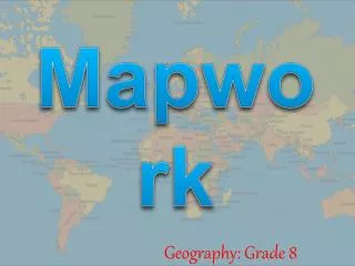
Mapwork
Mapwork. Geography: Grade 8. What is a map?. A map is a generalised and reduced representation of (a portion of) the curved surface of the earth on a flat surface. Topo-whaaat ?. What is a topographic map? A map that shows the features of the Earth’s surface.

Mapwork
E N D
Presentation Transcript
Mapwork Geography: Grade 8
What is a map? A map is a generalisedand reduced representation of (a portion of) the curved surface of the earth on a flat surface.
Topo-whaaat? • What is a topographic map? • A map that shows the features of the Earth’s surface. • What features are included? • Physical (natural) features (like hills, valleys, cliffs, rivers, marshes, vegetation) • Constructed features (like towns, roads, railways and sports fields).
How do we identify these features? • Conventional signs indicate features on maps. • The use of colour aids the interpretation od these symbols.
Point Line Area What is a conventional sign? • A letter or symbolindicating a particular feature
Where does colour come into the picture? • Distinguish between two types of landscape: • the natural / physical landscape • the constructed / human landscape Making it easier: - Brown - Blue • Five colours - Green - Black - Red
Brown Symbol
Blue Symbol
Green Symbol
Red Symbol
Black Symbol
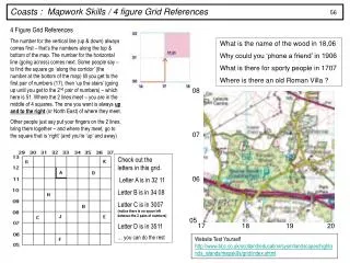
How do we find positions on topographical maps? • By using a grid reference we can easily pin point information on a map.
North Pole (90° N) Northern Hemisphere SouthernHemisphere South Pole (90° S) Latitude Equator (0°)
Eastern Hemisphere Western Hemisphere Longitude North Pole (90° N) Greenwich Meridian 0° South Pole (90° S)
Northern Hemisphere Western Hemisphere Eastern Hemisphere Southern Hemisphere Latitude & longitude S;E
1 2 3 4 5 A B C D E F
1 2 3 4 5 A B C D E F