Download
1 / 28
280 likes | 418 Vues
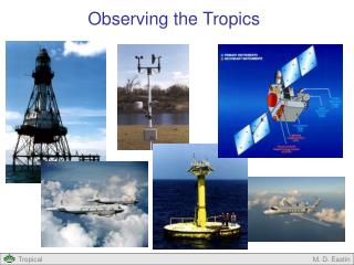
Observing the Tropics. Outline. Observing the Tropics Surface Observations Atmospheric Soundings Aircraft Satellites. Surface Observations: Land-based. Surface Weather Stations Automated and manual reports each hour Measure wind, pressure, temperature, humidity,

E N D
Observing the Tropics M. D. Eastin
Outline • Observing the Tropics • Surface Observations • AtmosphericSoundings • Aircraft • Satellites M. D. Eastin
Surface Observations: Land-based • Surface Weather Stations • Automated and manual reports each hour • Measure wind, pressure, temperature, humidity, • precipitation, cloud cover, and visibility The ~7200 Regularly-Reporting Surface Weather Stations Tropics (30ºS-30ºN) M. D. Eastin
Surface Observations: Buoys • Drifting Buoys • Attached to sub-surface “anchor” • Float freely on surface • Measure oceanic currents, SSTs, • surface wind and pressure • Regular data transmitted via satellite • Moored Buoys • Anchored to sea floor • Measure surface wind, temperature, • pressure, humidity and SSTs, • Important for El Nino and TC forecasts • Regular data transmitted via satellite Surface Float Anchor M. D. Eastin
Surface Observations: CMAN and Ships • Coastal Marine Automated Network (CMAN) • Offshore surface stations near coasts • Measure winds, temperature, pressure, • humidity, SST, waves, water level, • precipitation, and visibility • Regular data transmitted via satellite • Ship Reports • Most commercial ships report hourly • observations of wind pressure, temperature, • humidity and SST • Irregular data (no requirement to report) CMAN - Fowey Rock, FL M. D. Eastin
Surface Observations: Drifting Buoys Tropics (30ºS-30ºN) M. D. Eastin
Moored Buoys and CMAN Locations Tropics (30ºS-30ºN) Moored Buoys CMAN Stations Common Ship tracks Floating Buoys M. D. Eastin
Global Sounding Network • GPS Rawindsondes • Launched twice daily (at 0000 • and 1200 UTC) from the surface • Both • Observe quasi-vertical profiles • of wind, pressure, temperature, • and relative humidity • GPS Dropwindsondes • Launched from aircraft for “high-impact” • forecasts (e.g. TCs and winter storms) M. D. Eastin
Global Sounding Network Standard 1200 UTC Rawindsonde Sites Tropics (30ºS-30ºN) M. D. Eastin
Aircraft Observations • Aircraft Reports • Commercial aircraft continuously measure • winds, pressure, temperature, and humidity • (required to fly the aircraft) • Many report observations at regular intervals • Take-offs and landings provide numerous • quasi-vertical soundings • Multiple “cruising-altitudes” provide copious • upper-level observations in the “standard • air traffic lanes” Selected aircraft observations over the United States during a 3 hr period M. D. Eastin
Aircraft Observations Air Force 53rd Weather Reconnaissance Squadron Ten C-130 Hercules Regular Flights (around the clock) Into any TC threatening U.S. “Territory” or “Interests” Monitor storm Location and Intensity M. D. Eastin
Aircraft Observations Occasional Flights Into a few Hurricanes Collect data to help improve forecasts NOAA Research Aircraft Two P-3 Orions Two Gulfstreams M. D. Eastin
Aircraft Observations Inside a NOAA P-3 Orion Aircraft M. D. Eastin
Aircraft Observations NOAA Aircraft Tail Doppler Radar Belly Radar GPS Dropsonde Eyewall of Hurricane Guillermo 1997 M. D. Eastin
Geostationary (GOES) Satellites • 5 satellites (GOES-W, GOES-E, Meteosat, GMS, IODC) provide global coverage • Winds are obtained from automated tracking of cloud features • Use of VIS, IR, and WV imagery allows 24-hr wind detection at ~1hr intervals GOES-EAST Mid to Upper-level Winds from WV Imagery M. D. Eastin
Polar-Orbiting Satellites: AMSU / SSMI • Advanced Microwave Sounding Unit (AMSU) OR • Special Sensor Microwave Imager (SSMI) • Passive Radiometers: measure microwave emissions from atmosphere / ocean • Can determine atmospheric temperatures at 15 latitudes • Can determine atmospheric moisture at 5 levels • Can also determine cloud liquid water, rain-rate, and ice-water content Resolution of AMSU data in history and sample scan pattern M. D. Eastin
Polar-Orbiting Satellites: AMSU / SSMI Total Precipitable Water obtained from AMSU Tropics (30ºS-30ºN) M. D. Eastin
Polar-Orbiting Satellites: AMSU / SSMI • Applications in Tropical Cyclones • AMSU • Identify any upper-level “warm core” • (Is a system a tropical storm?) • Estimate the magnitude of the upper • level warm core • (As tropical cyclones become • more intense, their upper level • temperatures increase) Hurricane Dean (2007) M. D. Eastin
Polar-Orbiting Satellites: AMSU / SSMI • Applications in Tropical Cyclones • SSMI – 85 GHz • Identify whether a Tropical Storm • or weak Hurricane is developing or • has an eye • Helps pinpoint the center of circulation • when clouds are obscuring the eye • Sensitive to graupel and ice crystals • Helps identify the location of deep • convection and strong rainbands • below the upper-level clouds Hurricane Gilma (2012) IR VIS Composite 85 GHz M. D. Eastin
Polar-Orbiting Satellites: AMSU / SSMI • Applications in Tropical Cyclones • SSMI – 37 GHz • Identify whether a Tropical Storm • or weak Hurricane is developing or • has an eye • Helps pinpoint the center of circulation • when clouds are obscuring the eye • Sensitive to liquid water drops • Helps identify the location of low-level • convection and shallow rainbands • below the upper-level clouds • Can be used to forecast the rapid • intensification of a tropical storm • or hurricane Hurricane Gilma (2012) IR VIS 37 GHz 85 GHz M. D. Eastin
Polar-Orbiting Satellites: ASCAT • Advanced Scatterometer(ASCAT) and Oceansat-2 Scatterometer (OSCAT): • Emits pulse of radiation toward Earth (at 13.4 GHz microwave) • Capillary waves (~1 cm) on ocean surface backscatter the pulse • More backscatter = Greater surface roughness = Stronger winds ASCAT winds from 1-day ~60% global coverage Less Tropical Coverage M. D. Eastin
Polar-Orbiting Satellites: ASCAT TD-14 (2003): Scatterometers can observed surface circulations when it is not apparent by other means M. D. Eastin
Polar-Orbiting Satellites: ASCAT • Scatterometers • Limitations: • Unrealistic wind directions at very low • and very high wind speeds • Large wind speed errors can occur • in heavy precipitation • Precipitation attenuates (blocks) the • beam from reaching the surface • Splash caused by drops impacting the • surface increases the backscatter • Errors are a function of rain rate and • wind speed (hard to remove) Hurricane Dean (2007) Max Winds = 125 kts Note: Winds near the eye show no circulation and maximum winds ~60 knots M. D. Eastin
Polar-Orbiting Satellites: ASCAT • Scatterometers • Limitations: • Often under-estimates the • intensity of hurricanes, but • performs well with tropical • storm strength systems QuickSCAT Average Intensity Bias From Brennen et al. (2009) M. D. Eastin
Polar-Orbiting Satellites: TRMM • Tropical Rainfall Measurement Mission (TRMM) • TRMM microwave imager (TMI) is • similar to AMSU/SSMI instruments • Precipitation Radar (PR) is an active • radar looking down on convection • (first radar in space!) • Visible and IR Scanner (VIRS) is • similar to the GOES sensors • Lightning imaging Sensor (LIS) detects • cloud-to ground and cloud-to cloud • lightning from space (a first) • Cloud-Earth Radiant Energy System • (CERES) measures outgoing-longwave • radiation (OLR) to help detect global warming M. D. Eastin
Polar-Orbiting Satellites: TRMM • Tropical Rainfall Measurement Mission (TRMM) • Mission is to provide detail observations of convection and • its various characteristics over the entire data sparse tropics Global IR Composite: 23 October 2006 1200 UTC TRMM Radar Composite: 23 October 2006 1200-1500 UTC M. D. Eastin
Polar-Orbiting Satellites: TRMM • TRMM pass over Hurricane Dean (2007): • Inner swath (PR) shows rainfall rates (red/white = highest) • Outer swath (TMI) helps detect circulation centers, eyes, deep convection, and rainbands Inner Swath Outer Swath TMI pass near landfall of the 2004 Brazilian hurricane. Red areas represent strong convection. The center of the circulation is noted with an arrow. M. D. Eastin
Observing the Tropics • Summary: • Surface Weather Stations • Buoys, CMAN, and Ships • Rawindsondes and Dropsondes • Aircraft (Commercial, Air Force, Research) • GOES (VIS, IR, WV) • AMSU • SSMI • ASCAT • TRMM M. D. Eastin