Download
1 / 1
10 likes | 136 Vues
Aircraft-based CO 2 and CH 4 flux estimates from the city of Indianapolis: assessment of uncertainties and comparison with bottom-up approach.

E N D
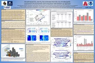
Aircraft-based CO2 and CH4 flux estimates from the city of Indianapolis: assessment of uncertaintiesand comparison with bottom-up approach Maria Obiminda Cambaliza1, Paul Shepson1, Dana Caulton1, Brian Stirm1, Kenneth J. Davis2, Thomas Lauvaux2, Antonio Possolo6, Daniel V. Samarov6, James R. Whetstone6, Jocelyn C. Turnbull5, Anna Karion3,4, Colm Sweeney 3,4, Tim Newberger3,4, Kevin R. Gurney7, Igor N. Razlivanov7, Jianhua Huang7, Brittany Moser1, Kelly Mays1 1 Purdue University, 2 The Pennsylvania State University, 3NOAA/ESRL, Colorado, 4CIRES, University of Colorado, 5National Isotope Center, New Zealand, 6NIST, Maryland, 7Arizona State University GC53B - 1279 Table 1. Sensitivity Analysis results showing the % change in the measured flux of CO2 and CH4, for three different flight days, when the listed parameter is varied by the magnitude of the uncertainty (1σ). INTRODUCTION Successful implementation of climate change mitigation strategies requires a good understanding of the sources and sinks for greenhouse gas sources, and the ability to investigate them experimentally. The fossil fuel emission component of the global carbon budget is well constrained in some regions of the globe, and less well in others. There is a critical need for accurate measurements and emissions models, as well as approaches to evaluate the uncertainties for emissions flux measurements. The Indianapolis Fluxexperiment (“INFLUX”) focuses on development and evaluation of bottom-up and top-down approaches to better constrain uncertainties in urban greenhouse gas emissions, using Indianapolis as a case study. Here we focus on results from several aircraft-based mass balance flux measurements in Indianapolis. CO2and CH4 were measured from an aircraft-based platform (Purdue University’s Airborne Laboratory for Atmospheric Research (ALAR)), equipped with a Picarro cavity ring-down CO2/CH4/H2O spectrometer, a flask sampling system, a GPS/INS system, and a Best Air Turbulence probe for high-resolution wind measurements. OBJECTIVES Our objective is to improve and define the uncertainty of our flux measurements. We investigate the sensitivity of the estimated CO2 and CH4 emissions flux to changes in various measurement and analysis parameters, e.g., regional background concentration of CO2 and CH4, height of the convective boundary layer (CBL), wind speed, and choice of interpolation technique used in the mass balance calculations. We also evaluate the precision of the method through flux measurements at multiple downwind distances, for two different point sources. For the Indianapolis Harding St. Power Plant (a ~600MW coal boiler), we compare our flux estimates to the EPA CEMs data. We also compare our city-wide CO2 emissions flux measurements to the output of the Hestia data-model product. RESULTS AND DISCUSSION, continued To evaluate the accuracy of the method, we have measured CO2 fluxes for the part of the Indianapolis total flux that is attributable (using back trajectory analysis) to the Harding St. Power Plant, and then we compare that to the emission rate reported by the utility to EPA. The results for several such measurements are shown in Figure 5. The average difference in this case is 50%, although that is largely driven by the 6/1/2012 data point. For the latter experiment, we measured the flux for three downwind distances, resulting in a relative standard deviation of 42%. We also compared the city-wide CO2 flux measurements with model results from Vulcan/Hestia (http://hestia.project.asu.edu/project_overview.shtml), a bottom-upapproachforquantifyingurbanemissions. The results are shown in Figure6. On average, the measured values are 38% greater than the Hestia emissions, the latter not exhibiting the same day-to-day variability. This difference is currently underinvestigation. Fig. 2. Flight path on June 1, 2011 showing the horizontal transects directly downwind of the city. RESULTS AND DISCUSSION, continued To evaluate the precision of the method, we conducted several flux measurements for point and small-area sources (landfills and power plants), for multiple downwind distances. Fluxes from such smaller sources are easier to quantify for multiple downwind distances within the stationarity constraints, becase the transects are much shorter. In Figure 4, we show results for measurement of the CH4concentrations from the Newton Co. landfill (Indiana), one of the three largest landfill in the U.S. The flux was measured in about 1 hr., for two downwind distances, 11, and 16 km. One can readily see that the plume is more dispersed for the 16 km transects. As shown in the figure, the two flux results differ by 23%. This apparent precision is better than what can be achieved for an urban area source, because there are more transects, and the S/N ratio is typically larger. FLIGHT DESIGN and MASS BALANCE APPROACH The flight plan was designed based on the experimental theory depicted in Figure 1. Wind (from the right) carrying background concentrations of CO2 and CH4 blows over the city, where it picks up greenhouse gas emissions from anthropogenic sources such as cars, power plants, etc. By flying horizontal transects normal to the prevailing wind direction downwind of the city, enhancements in CO2 and CH4 above background were intercepted, detected and quantified by the on-board aircraft sampling system from the ground to the top of the boundary layer. Figure 2 shows , as an example, the horizontal transects on June 1 , 2011 flight experiment. The curtain flight transects span distances longer than the diameter of the city (~70 km) to clearly distinguish background concentrations of CO2 and CH4 from elevated fossil fuel signals from the Indianapolis air shed. The horizontal distribution of CO2 as a function of the height above the ground (Figure 3) shows the elevated concentrations of CO2 that can be traced back to the Harding Street Power Plant southwest of the city. The mass balance approach uses the wind speed perpendicular to the flight path as well as the background concentration to find the change in concentration which is then integrated over the bounds of the city according to the equation: 22,000 moles s-1 203 moles s-1 Fig. 3. Observed CO2 and CH4 in downwind transects (panels A and B) for June 1, 2011, along with the interpolated data from these transects in panels C and D. RESULTS AND DISCUSSION In Figure 3 above we show the raw data from the June 1, 2011 flight transects (top) and the kriged (interpolated) results in the bottom two panels. Using the kriged winds, and background profile, we calculated fluxes for this day of 22,000 moles s-1for CO2, and 200 moles s-1for CH4. We examined the sensitivity of the calculated fluxes for three days in 2011 (March 1, April 29, and June 1) to four important variables that influence the calculation: Convective boundary layer (CBL) height (upper limit of the interpolated data) background greenhouse gas concentrations perpendicular wind speed interpolation method The CBL height uncertainty was estimated from the change in height (measured or modeled) over the measurement period. For the background gas concentrations and the wind speeds, we propagated the measurement uncertainties for the average cell. We investigated the impact of the interpolation method by using two quite different methods, and comparing the results. The results of the sensitivity test (Table 1) indicate that for CO2, the most important factor is the uncertainty in the background concentrations. Our procedure can be improved through measurement of the background concentrations from upwind transects in the middle of the boundary layer. For both CO2 and CH4, uncertainty in the CBL depth is important. This is relatively easy to improve, through improved surface-based remote sensing of CBL heights. We find that this approach has a significant uncertainty component from the variability in the wind speeds, and this will be difficult to improve, although perhaps doppler LIDAR systems could also be used to improve this information. We find that the dependence on interpolation method is the smallest component of the uncertainties; this can be minimized by increasing the data coverage, e.g. through use of faster or multiple simultaneous aircraft measurement. Fig. 5. CO2 flux measurements, and those reported, for the Harding St. Power Plant in Indianapolis. Fig. 6. CO2 flux measurements, and those modeled from Vulcan/Hestia, for Indianapolis. CONCLUSIONS At the present time, we find that the precision of this particular aircraft-based greenhouse gas flux method is on the order of ±30% for point sources and small area sources, and ±40% for urban area sources. This can be improved through acquisition of background data, e.g., from towers, and boundary layer height information from remote sensing. Both of these enable improvement in the sampling coverage. We believe that uncertainties on the order of 20% should be possible. For megacities, or for lower uncertainties in general, flux measurements would require measurements from multiple aircraft. Fig. 1. Illustration of the mass balance approach. Wind carrying background concentrations of CO2 and CH4 blows over the city, where it intercepts and picks up greenhouse gas emissions from anthropogenic sources such as cars, power plants, land fills, etc. Flux across the downwind perpendicular plane is measured. ACKNOWLEDGMENT INFLUX is funded by the National Institute of Standards and Technology. We also thank and acknowledge Purdue University ‘s Jonathan Amy Facility for instrumentation support in this exciting project. Fig. 4. CH4data for two downwind distances from the Newton Co. landfill in Indiana.