Surface Water
Surface Water. Surface Water Movement. W ater cycle - earth’s water is recycled through two main processes: condensation and evaporation. It is also referred to as the hydrological cycle. Water Cycle. Process. 1) Evaporation – Changing a liquid to a gas,


Surface Water
E N D
Presentation Transcript
Surface Water Movement Water cycle - earth’s water is recycled through two main processes: condensation and evaporation. It is also referred to as the hydrological cycle.
Process • 1) Evaporation – Changing a liquid to a gas, • 2) Condensation - changes a gas to a liquid • 3) Precipitation - falling of H2O from the sky as rain, sleet, snow, hail, etc. • 4) Run off - water flowing down a slope along the earth’s surface • amount of run off is determined by the size of pores or spaces where water can accumulate. Vegetation soils allow water to seep into the ground, compact soils do not. Light precipitation gives water time to seep downward, heavy precipitation does not. • Holding capacity of the soil is affected by the chemical/ physical composition of the soil.
Soil Humus is decayed organic matter with minerals • Particle size determines the amount of water that seeps into the ground. • Humus - medium size/ Sand - large/ Clay fine (less penetrable) • Slopes allow water to move from high level to low levels. Greater potential for erosion.
Stream Systems Stream Systems Water other than run off, sometimes collects in channels as run off increases so does the channel. (erosion widens out) - a stream is born. Large channels create rivers fed by tributaries.
Streamload All the material’s that are carried with the movement of water in a channel. There are 3 ways to carry a load: • 1) Solution- materials are dissolved in a stream’s water. Ex. Calcium carbonate, limestone, and marble amounts are expressed as parts per million (ppm) Streams commonly carry magnesium compounds. • 2) Suspension - particles are held up by the turbulanceof the • Stream • 3) Bedload - sand, pebbles, and cobbles force of the water to pull and push or roll the material along the bed of the stream
Carrying Capacity Ability of the stream to transport material, dependent on the velocity and amount of moving water Bed abrasion occurs when materials rub off one another - erodes the bed
Carrying Capacity Cont… • The channels slope, depth and width affect the speed and direction in which the water moves. • Discharge - measures the volume of water that flows over a • particular location within a given time period - expressed in m³/sec • Formula: D = w x d x vof H2O • Depth width depth volume • Mississippi - average discharge 173,600 m³/sec • Flood Plain - river over flow banks and water floods the land along the river bed • Amazon River - 10x the discharge as the Mississippi River - is the largest river in the world
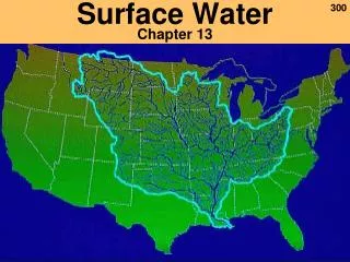
Small streams - brook and creeks, Watershed - all the land area whose water drains into a stream. (drainage basin) ex. Mississippi - largest river in the U.S. • Flood Plains are the most fertile land and at times used for farming • Sediment is dropped as the floor recedes • Floods are natural occurrences • Upstream floods - floods of areas due to heavy rainstorms • Gauging Station and satellites monitor the flow of water
Stream Development • Stream Development • Stream changes width, shape, and size and the landscape as it flows - adequate supply of water is needed • Headwaters - region where water accumulates to supply the stream - commonly found in mountains • Moving water carves a narrow path - stream channel • Stream bank - sides of the channel Rock and soil are eroded away called head ward erosion • V-shaped channels are formed with steep sides - called gorges or canyons, ex. Colorado River. A usable chasm - Yellowstone River. • Erosion will continue until its bas level reaches sea level
Meandering Streams • Streams that are U shaped and with little slope. • The water begins to erode the over all path is bent or curved – meander.
Oxbow Lake • When deposition drops enough sediment, it blocks the meandering • · Forms and Oxbow Lake • Deposition • · Forms deltas - ex. Mississippi deposit
WetLands Wetlands - land area that is covered with water for a large part of the year, ex. Bogs, marches, swamps Bogs - not stream fed, water comes from precipitation Water logged soils - peat moss (Sphagnum) Soil is very acidic due to the decay of peat moss Plant species - Venus Fly Trap, sundew Marsh grasses trap sediments - slows down water
Lakes And Fresh water Lakes - Depression in the surface materials of the landscape that collects and holds water Some are oxbow, glacial origin (Great Lakes) Prehistoric Lake - Great Salt Lake (Utah) Cirque - carved lakes in the mountains by valley glaciers Precipitation, runoff and underground sources maintain the water supply
Eutrophication - Aprocess of a lake becoming rich in nutrients from the surroundings, Ex. big algae bloom (pond scum - slimy substance) Over population creates a depletion of O2
Wetlands • Wetlands - land area that is covered with water for a large part of the year, ex. Bogs, marches, swamps • Bogs - not stream fed, water comes from precipitation • Water logged soils - peat moss (Sphagnum) • Soil is very acidic due to the decay of peat moss • Plant species - Venus Fly Trap, sundew • Marsh grasses trap sediments - slows down water
Moraine dammed lakesglacier gauged out of the land during the ice age.
Glacial Moraines Glacial moraines originally dammed some of these depressions and restricted the outward flow of water.
Kettle Lakes Kettle lakes - formed as blocks of ice left on the outwash plain ahead of melting glaciers eventually melted and left depressions called kettles. When these depressions filled with water, they formed kettle lakes.