Comprehensive Monitoring System for Physical Oceanography in Lopez Island Study Area
Establishing a long-term monitoring system using ADCPs, CTDs, Tide Gages, and Cameras to study stratified flow and other phenomena in Lopez Island's dynamic ocean environment. Primary research focus is understanding flow over topography.

Comprehensive Monitoring System for Physical Oceanography in Lopez Island Study Area
E N D
Presentation Transcript
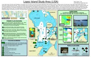
Lopez Island Study Area (LISA) TG TG FC TG TG TG FC FC FC BA BA ES TG TG ES FC DB MB DB MB MB WB WB Wayne Martin UW wmartin@ocean.washington.edu Lopez Island is part of the San Juan Archipelago, at the eastern end of the Strait of Juan de Fuca, between Washington State and British Colombia. LISA is an area on the east side of Lopez Island, approximately 5X8 km, with several bays, small islands and channels. There is an energetic tidal forcing through Lopez Pass where currents exceed 1 m/s on a daily basis. Within LISA, there are distinct sites with repeatable conditions of interest including high turbulence, dissipation and mixing, non-hydrostatic flow, internal wave generation, flow separation, wetting and drying and significant tidal depth variations. Over the next several years, we intend to develop a comprehensive, long-term monitoring system for the physical oceanography at LISA using ADCPs, CTDs, tide gages and stereographic cameras. We will also implement one or more detailed numerical models, beginning with ROMS, and including data assimilation from the sensor suite. Our primary research interest is the understanding and modeling of stratified flow over topography. However, LISA will also be available for biological and other research that can benefit from a detailed knowledge of the physical environment. We expect that the new tangent linear and adjoint features of ROMS 3 will play an important role in this work, for example in sensitivity analysis and data assimilation. 2 LOPEZ PASS ILLUSTRATIVE SAMPLES FOR FLOOD CONDITIONS ( NOT TAKEN AT THE SAME TIME OR BASED ON SAME FORCING) 20 DECATUER I Vancouver Is. Juan de Fuca 8 Lopez Island Victoria Washington Seattle Juan de Fuca LOPEZ SOUND Lopez Island Washington – BC Area San Juan Islands 7 • PRIMARY FLOW FEATURES • Lopez Pass open boundary: Peak daily tidal flow >1 m/s. Highly turbulent and well mixed. Detailed measurements will be harmonically analyzed at each tidal component so conditions can be predicted from continuous tide gage data. • Lopez Sound open boundary: Flows expected to be small. Similar measurement and prediction program to Lopez Pass. • Lopez Pass into body of Hunter Bay: Highly turbulent area with strong surface features and possibly generation of internal waves. • Primary signal is position of tidal front. • Rim, Ram and Rum Island channels: Three similar but different width channels driven by the same Lopez Pass currents. Each drops from the Lopez Pass plateau into deeper water with varying steepness. Expect non-hydrostatic conditions. • 5 Mud bay: a shallow bay with drying flats. Expect maximum affect of surface fluxes in this area. 1 25 Mid-depth currents: blue to west, red to east CENTER I SURFACE FEATURES FROM FC1 ROMS SIMULATION 2 50 ALONG TRACK 3 4 1 4 20 1 4 CROSS TRACK 30 5 3 SPERRY PENINSULA 400 x 650 Gridded Bathymetry (~10 m grid) VERTICAL • FACILITIES and SENSORS • HUBB: HUnter Bay Base (lab, dock, shop, TG). All data will be input to HUBB via a LISA wide wireless intranet. All sensor data and model results will be archived and posted on the LISA web site. • “RV TRACER”: 22’ SeaSport (ADCP, CTD, ES) • TG: Tide Gage • ES: Environmental Suite (wind, air, etc.) • BA: Bottom Mounted (movable) ADCPs • FC: Fixed Cameras • MB: Moored Buoy (ADCP, CTD, ES) • DB: Dynamically Positioned Buoy (ADCP, CTD, ES) • WB: Wireless Intranet Bridge SPERRY PENINSULA HUNTER BAY HUBB HUBB BASIC FLOW AND ADCP TRACK HUBB ADCP TRANSECT 4 2 MOBILE PLATFORMS MUD BAY LISA-1 LISA-1 Lopez Island 5 1 1km PHASE II DP BUOY ADCP, CTD, Environmental, GPS Disk hull, Dynamic Positioning by drift, thrusters and mooring PHASE I MOORED BUOY ADCP, CTD, ENVIRONMENTAL, GPS catamaran hull, conventional mooring RV “TRACER” ADCP, CTD, ENVIRONMENTAL, GPS 22’ SeaSport, 25 knots (Depths in Meters)
Light, Flag, Antenna, GPS and Sensors LISA-1 LISA-1 Payload Container, Winch and ADCP Bumpers Vertical Profiling Sensor Package And Anchor LISA AUTONOMOUS SURFACE VEHICLE Polypropylene Hull with Batteries and Thrusters
LISA-1 LISA-1
WINCH: Precise up/down control, no slip rings, any size cable FORCING THIS WEEK Tidal Height - ft Current Speed in Lopez Pass – m/s
Meteorological Sensors, Light, and Antenna WINCH: Precise up/down control, no slip rings, any size cable Estimated Cost w/o Sensors: $5000 with Baseline Sensors: $20000 INSTRUMENT BOX: Laptop, Watch Dog Timer, 8 Port USB/RS232, Weather I/F, RF Modem, Control I/O BAT BAT Catamaran Hulls (Old Hobicat) 4 Point Mooring Profiling CDT and other Instruments ADCP: Current Velocities, Back Scatter, Heading, Pitch, Roll LISA Prototype Profiling Buoy