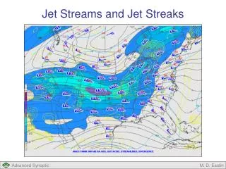
Jet Streams and Jet Streaks
360 likes | 718 Vues
Jet Streams and Jet Streaks. Jet Streams and Jet Streaks. Jet Streams Definition and Basic Characteristics Basic Forcing Mechanism Common Jets in the Mid-latitudes Jet Streaks Definition and Basic Characteristics Vertical Motion Pattern Coupling with Surface Fronts

Jet Streams and Jet Streaks
E N D
Presentation Transcript
Jet Streams and Jet Streaks M. D. Eastin
Jet Streams and Jet Streaks • Jet Streams • Definition and Basic Characteristics • Basic Forcing Mechanism • Common Jets in the Mid-latitudes • Jet Streaks • Definition and Basic Characteristics • Vertical Motion Pattern • Coupling with Surface Fronts • Relationship to Severe Weather M. D. Eastin
Jet Streams • Basic Characteristics: • Long narrow band of strong winds • ~500-6000 km in length • ~100-400 km in width • Not a continuous band • Maximum winds ~50-250 knots • Can be located at any altitude • Common mid-latitude types • include the polar, subtropical, • and low-level jets • Migrate and evolve over times • scales from a few hours to • seasonally • Primarily influence the motion • and evolution of synoptic-scale • systems • Contribute to the initiation and • evolution of mesoscale systems • and deep convection M. D. Eastin
Jet Streams • Basic Forcing Mechanism: • All jets are a response to flow down strong • large-scale pressure gradients (produced • by temperature gradients) that is then turned • by the Coriolis force • All long-lived jets are in thermal wind balance J Mean Zonal Wind J Mean Temperature North Pole L Jet H PGF L PGF Coriolis force turns wind H Maximum N-S Temperature and Pressure Gradient Equator M. D. Eastin
Jet Streams • Basic Forcing Mechanism: Thermal Wind Balance • Notice how all of the strong upper-level jets (at 300 mb) are located directly above a strong low-level temperature gradient (at 850 mb) M. D. Eastin
Common Jet Streams • Polar-Front Jet (PFJ): • Often located near 300 mb just below the mid-latitude tropopause • Winds are westerly (blow west to east) and often exceed 75 m/s • Associated with strong quasi-horizontal temperature gradients at low-levels • (Note: Jet migration is a response to the strong temperature gradient moving) • Present year round • Furthest north (~50ºN) • and weakest during • the summer months • Furthest south (~35ºN) • and strongest during • the winter months • Most deep convection • develops equatorward • of the polar jet Isentropic Mean Meridional Cross Section M. D. Eastin
Common Jet Streams • Subtropical Jet (STJ): • Often located near 200 mb just below the tropical tropopause • Winds are westerly but rarely exceed 50 m/s • Associated with a moderate quasi-horizontal temperature gradients at mid-levels • Primarily a wintertime • phenomenon • Meanders between 20ºN • and 35ºN • Often is oriented from • the southwest to the • northeast across the • Pacific and southern • or western U.S. • (“pineapple express”) • Most deep convection • develops poleward of • the subtropical jet Isentropic Mean Meridional Cross Section M. D. Eastin
Common Jet Streams • Subtropical Jet (STJ): • Often very difficult to distinguish • from the polar jet on daily weather • maps • Since the subtropical jet is located • further south (where f is smaller), • a strong jet can still develop from • a moderate temperature gradient • Let’s do a simple analysis assuming • the following are held constant: • ∂p ~ 800 mb • p ~ 500 mb • Rd ~ 300 J/kg/K • ∂y ~ 1000 km Polar-Front Jet Subtropical Jet Polar Jet:Φ ~ 40ºN ∂T ~ 20 K Subtropical Jet: Φ ~ 20ºN ∂T ~ 10 K ∂ug ~ 98 m/s ∂ug ~ 92 m/s M. D. Eastin
Common Jet Streams • Low-level Jets (LLJ): • Located 500-2000 m AGL • Winds rarely exceed 25 m/s • Associated with weak horizontal • temperature gradients confined • to lower levels • Can occur year round • 1. Pre-frontal LLJ: • Located just ahead (east) of • strong cold fronts • Responsible for the rapid • advection of warm moist air • that can help “feed” deep • convection along the front LLJ Cold Air Warm Air J Cold Air Warm Air M. D. Eastin
Common Jet Streams • 2. Nocturnal LLJ: • Primarily oriented north-south • Maximum intensity at night in the summer • Increased nocturnal thunderstorm activity • is partially a result of the LLJ providing a • continuous supply of warm, moist air to • the storm cloud bases • Intensity fluctuations are linked to diurnal • changes in the low-level temperature • gradients along the gradually sloping • (east-west) topography East-West Cross Section 9 June 2002 at 12Z Potential temperature (red contours) Wind speed (shading) Warm Air J Nocturnal Boundary Layer – Radiational Cooling LLJ M. D. Eastin
Jet Streaks • Basic Characteristics: • Faster moving “pockets” of air • embedded within the jet stream • ~250-1000 km in length • ~50-200 km in width • Migrate and evolve over times • scales from a few hours to a • few days • Motion is often much slower • than the speed of the wind • within the jet stream or streak • Primarily influence the initiation • and evolution of mesoscale • systems and deep convection • Contribute to the evolution of • synoptic-scale systems since • most contain strong PVA Jet Streaks Jet Stream M. D. Eastin
Jet Streak Vertical Motions • Physical Interpretation of the Basic Pattern: • Using a simplified vorticity equation: • Thus, the vorticity change experienced by • an air parcel moving through the jet streak: • Vorticity decrease → Divergence aloft • → Upward motion • Vorticity increase → Convergence aloft • → Downward motion • Recall: QG theory provides an alternative • explanation (with the same result) • Divergence / convergence patterns • result from ageostrophic motions Vort Max Left Exit Left Entrance + Vorticity Increase Vorticity Decrease JET Vorticity Change Divergence _ Vorticity Decrease Vorticity Increase Right Exit Right Entrance Vort Min Left Entrance Left Exit Descent Ascent JET Ascent Descent Right Exit Right Entrance M. D. Eastin
Jet Streak Vertical Motions An Example: Divergence = yellow contours Regions of expected upward vertical motion M. D. Eastin
Jet Streak Vertical Motions An Example: • Important Considerations!!! • Forcing is at upper-levels • Forcing is on the synoptic scale • Is there a mechanism for low-level lift? • Is the low-level environment moist? M. D. Eastin
Coupling between Jet Streaks and Fronts • The orientation of a surface front and an upper-level jet streak can lead to either • enhanced (deep) convection or suppressed (shallow) convection along the front • Enhanced Convection → Left exit or right entrance region is above the front • → Helps destabilize the potentially unstable low-level air • → Increases the likelihood of deep convection M. D. Eastin
Coupling between Jet Streaks and Fronts • The orientation of a surface front and an upper-level jet streak can lead to either • enhanced (deep) convection or suppressed (shallow) convection along the front • Suppressed Convection→ Left entrance or right exit region is above the front • → Prevents destabilization of the potentially unstable air • → Decreases the likelihood of deep convection M. D. Eastin
Coupling between Jet Streaks and Fronts • The orientation of a surface front , an upper-level jet streak, and a low-level jet streak can further enhance deep convection along the front • More Enhanced Convection → A “favorable” combination of ageostrophic circulations • from each jet streak and the front can create strong • lift along the warm (unstable) side of the front • → Often the location of the most severe deep convection M. D. Eastin
Jet Streaks and Severe Weather • Is severe weather often associated with jet streaks? • Recent climatology conducted by Clark et al. (2009) • Examined the location all severe weather reports (tornado, hail, winds) relative to any • upper-level jet streaks during the warm season (March-September) of 1994-2004 • Expectations: • Most severe weather is associated with jet streaks • → Increased vertical shear • → Enhanced storm longevity • More severe weather in the right entrance and left-exit regions • → Enhanced vertical motion • → Greater likelihood of surface parcels being lifted to LFC • → Greater near-surface moisture convergence M. D. Eastin
Jet Streaks and Severe Weather • Answer: Yes - severe weather is regularly associated with jet streaks • Results: • A total of 126,864 storm reports occurred during the period of study • 84% were associated with an upper-level jet streak. M. D. Eastin
Jet Streaks and Severe Weather • Where is the severe weather located? • Results: • Majority of reports • are located in the • right-entrance • region and along • the jet streak axis • in the exit region Left Entrance Left Exit Right Entrance Right Exit M. D. Eastin
Jet Streaks and Severe Weather Composite Structure: M. D. Eastin
Jet Streaks and Severe Weather Composite Structure: M. D. Eastin
References Beebe, R. G., and F. C. Bates, 1955: A mechanism for the assisting in the release of convective instability. Mon. Wea. Rev., 83, 1-10. Bluestein, H. B., 1986: Fronts and jet streaks: A theoretical perspective. Mesoscale Meteorology and Forecasting, Amer. Meteor. Soc., Boston, 173-215. Bluestein, H. B., 1993: Synoptic-Dynamic Meteorology in Midlatitudes. Volume II: Observations and Theory of Weather Systems. Oxford University Press, New York, 594 pp. Bonner, W. D., 1968: Climatology of the low level jet. Mon. Wea. Rev., 96, 833-850. Browning, K. A., and C. W. Pardoe, 1973: Structure of low-level jet stream ahead of mid-latitude cold fronts. Quart. J. Roy. Meteor. Soc., 99, 619-638. Clark, A. J., C. J. Schaffer, W. A. Gallus, and K. Johnson-Omara, 2009: Climatology of storm reports relative to upper-level jet streaks. Wea. Forecasting, 24, 1032-1051. Keyser, D., M. J. Reeder, and R. J. Reed, 1988: A generalization of Pettersen’s frontogenesis function and its relation to the forcing of vertical motion. Mon. Wea. Rev., 116, 762-780. Krisnamurti, T. N., 1961: The subtropical jet stream in winter. J. Meteor., 18, 172-191. Murray, R., and S. M. Daniels, 1953: Transverse flow at the entrance and exit to jet streams. Quart. J. Roy. Meteor. Soc., 99, 619-638. Pyle, M. E., D. Keyser, and L. F. Bosart, 2004: A diagnostic study of jet streaks: Kinematic signatures and relationship to coherent tropopause disturbances. Mon. Wea. Rev., 132, 297-319. Uccellini, L. W., and D. J. Johnson, 1979: The coupling of upper and lower tropospheric jets streaks and implications for the development of severe convective storms. Mon. Wea. Rev., 107, 682-703. M. D. Eastin