Download
1 / 20
220 likes | 402 Vues
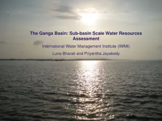
Spatio-Temporal variability of Water resources in the Ganga basin. By Subashisa Dutta Associate Professor E-mail : subashisa@iitg.ernet.in. Sattriya dance-Assam, http://www.gurleenmehak.blogspot.com/. DEPARTMENT OF CIVIL ENGINEERING INDIAN INSTITUTE OF TECHNOLOGY GUWAHATI

E N D
Spatio-Temporal variability of Water resources in the Ganga basin By Subashisa Dutta Associate Professor E-mail : subashisa@iitg.ernet.in Sattriya dance-Assam, http://www.gurleenmehak.blogspot.com/ DEPARTMENT OF CIVIL ENGINEERING INDIAN INSTITUTE OF TECHNOLOGY GUWAHATI GUWAHATI, ASSAM-781039 For National Students’ Conference On River Basin Planning IIT Kanpur, 4 to 5th November 2011
Overview of the lecture • Spatio-temporal variation of surface water resources in the basin • ( annual water yield, monsoon flow, non-monsoon flow, • lean month flow, dependable flow) • Current Ground water utilization : crop statistics and GIS analysis • Spatio-temporal variability of Ground water Resources in the Basin • Fertilizer application and crop productivity : • an indicator for non-point source pollution • Resilience in the Water Resources system: How long ?
Hydrological Storage, release function and interdependency SM P ET ET Surface water storage Q Irrigation Flood recharge M J S D J Q Monsoon recharge Ground water storage Q M J S D J M J S D J ET : Evapo-transpiration, P: Precipitation, SM: Snow Melting Run-off, Q: Discharge • Note for Ganga Basin: • Ground water Irrigation controlled by the farmers and Agricultural Economy, • Flood recharge depending upon the frequency of wet-Monsoon • ET depending upon the distribution of Landuse/landcovers remains fairly constant • Hydrological links between groundwater and surface water storage defined by Hydro-geological characteristics
Study Area: Ganga River basin in Bihar • Data used: • Hydrological data (1960 to 1992) • Satellite Altimetry data (1993 to 2003) • Ground water level data (2001 to 2009) • Agricultural statistics (Crop water requirement, productivity, Area, Crop type etc.) • Other ancillary information (Bhuvan satellite imagery,)
Hydrological Trends of the Ganga river flow* at the downstream of Farakka Pre-Surface water development Project Ground water development Project *Webster, J. P., Jian, J., Hopson, M. T., Paula, A. A., Chuang, H., Curry, J. A., Grossman, R. L., Palmer, T. N., Subiah, A. R., (2010) “Extended-range probabilistic forecasts of Ganges and Brahmaputra floods in Bangladesh.” Bulletin of the Am. Met. Society., 2911.1.
Hydrological trends of Major tributary flows Annual variation of water yield of the Kosi river at Saptakosi station Monsoon season Water yield: 43215 MCM Hydrological trend : Variable Non-Monsoonal Season Water yield: 9491 MCM Hydrological trend : Fairly Constant Monsoon season Water yield: 72287 MCM Hydrological trend : Variable Non-Monsoonal Season Water yield: 11467 MCM Hydrological trend : Variable * Report of the 2nd Bihar State Irrigation Commission 1994
Gandak-Burhi Gandak Mahananda Ground water(Buxar to Azamabad) Ghaghra Kosi Ramganga Gomti Mahananda 1184 (1487) 217 215 899 712 723 Buxar Bay of Bengal Main Ganga Azamabad 3888 393 228 Indo-Bangladesh Border 67 106 3164 Sone Chambal Farakka Barrage 349 Bhagirathi Tons-Karmnasa Yamuna Long term Average February month flow in Ganga river Findings: Indo-Bangladesh Ganga water sharing treaty: 3888 MCM at Farakka Ground water contribution: 1487 MCM All data are 75% dependable flow (Million Cubic Meter) * Report of the 2nd Bihar State Irrigation Commission 1994
Gandak-Burhi Gandak Mahanandaa Ground water(Buxar to Azamabad) Ghaghra Kosi Ramganga Gomti Mahananda 1184 (1236) 922 199 220 715 767 Buxar Bay of Bengal Main Ganga Azamabad 3888 298 235 49 Indo-Bangladesh Border 3120 114 Sone Chambal Farakka Barrage 365 Bhagirathi Tons-Karmnasa Yamuna Long term Average March month flow in Ganga river Findings: Indo-Bangladesh Ganga water share treaty: 3888 MCM at Farakka Ground water contribution: 1236 MCM All data are 75% dependable flow (Million Cubic Meter) * Report of the 2nd Bihar State Irrigation Commission 1994
Gandak-Burhi Gandak Mahanandaa Ground water(Buxar to Azamabad) Ghaghra Kosi Ramganga Gomti Mahananda 1018 953 (502) 129 228 715 920 Buxar Bay of Bengal Main Ganga Azamabad 3888 279 246 31 Indo-Bangladesh Border 215 2967 Sone Chambal Farakka Barrage 246 Bhagirathi Tons-Karmnasa Yamuna Long term Average April month flow in Ganga river Findings: Indo-Bangladesh Ganga water share treaty: 3888 MCM at Farakka Ground water contribution in April Month : 502 MCM Total three lean month flow GW = 3225 MCM ( 27%), Kosi and Gandak River flow = 4552 MCM ( 40%), U/S catchments at Buxer : 3386 MCM ( 29%) * Report of the 2nd Bihar State Irrigation Commission 1994
Satellite Altimetry measurement* for water level Main River Performance of Satellite altimetry for water level prediction in Brahmaputra Tributary Wet land Minimum water level variation from altimetry measurement * http://www.legos.obs-mip.fr/soa/hydrologie/hydroweb
Analysis of Groundwater variation: Depletion, Recharge and withdrawal * Report of the 2nd Bihar State Irrigation Commission 1994
Water requirement for Agriculture system Multiple cropping during Non-Monsoon season Estimated Ground water irrigation = 9800 MCM
Total crop water requirement and Annual variation of recharge 2004: Flood year
Temporal variability of Groundwater and Potential recharge MSS (1970’s) Field photograph of a wetland Temporal trend of annual recharge/depletion zones in three districts TM (1990) ETM (2000) Flood Area Flood inundation in Bihar in 2007 showing potential recharge zones
Conclusion Ground water irrigation, controlled by the farmers, is expected to be the major water resources user ( 10,000 MCM to 15,000 MCM) Conflict between Ground water irrigation and lean period flow in the river Wet monsoon year produces large-scale flood inundation based recharge system Availability of monsoon water yield is high and efficient management of the surface water projects Now, the water resources system is at resilience stage. How Long ?
ACADEMICBuilding, IIT Guwahati Thank You Research Group • Dr Subashisa Dutta • Dr. Bimlesh Kumar • Dr Suresh A. Kartha • Amit Kr Dubey • Ikram Ali • Pritam Biswas • Sangita Devi • Titas Ganguly Farmer in a wheat field crop harvesting at Bihar