Download
1 / 1
10 likes | 198 Vues
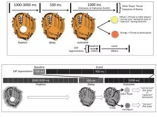
A study of lakes and wetlands in Africa from land surface modeling Huilin Gao, Theodore Bohn, and Dennis P. Lettenmaier Department of Civil and Environmental Engineering, Box 352700, University of Washington, Seattle, WA 98195 (hgao@u.washington.edu). Continued. 1. Objective. 4.

E N D
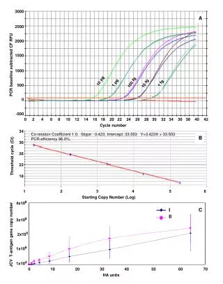
A study of lakes and wetlands in Africa from land surface modeling Huilin Gao, Theodore Bohn, and Dennis P. Lettenmaier Department of Civil and Environmental Engineering, Box 352700, University of Washington, Seattle, WA 98195 (hgao@u.washington.edu) Continued 1 Objective 4 Case study of Lake Chad, Africa 4 1) Without irrigation withdrawals, the north lake not only would have survived the droughts in the 1980s but would have merged with the south lake again for a brief period around 2000. • Lakes and wetlands are of great importance to the socio-economics of the African continent. However, information about variations in surface water storage in even the largest lakes is surprisingly sparse. Satellite altimeters now provide some information about variations in lake surface elevation and surface extent information is available from visible and other sensors. But for most lakes the variations of lake water storage (regardless of size) at interannual and interseasonal time scales is mostly unknown, and the variations due to long term climate change are beyond the present state of knowledge. We use a modified version of the Variable Infiltration Capacity (VIC) macroscale hydrology model, in combination with remote sensing data, to help understand water storage variations in lakes and wetlands across Africa. Lake Chad is used as a representative lake in this study. The objectives are two-folds: • To evaluate the land surface model by reconstructing the lake historically; • To analyze the impacts of climate change, human impact, and lake bathymetry on lake variations. • Study area: the vanishing Lake Chad Located in Central Africa with an area of 2,500,000 km2, the Lake Chad basin is the largest endoreic basin in the world. Lake Chad is shared by four countries: Chad, Niger, Nigeria and Cameroon. The hydrologically active part of the basin is mainly drained by the Chari–Logone river system, and to a much lesser extent, by the Komadugu River. In the 1960s Lake Chad had an area of more than 26,000 km², making it the fourth largest lake in Africa. By 2000 its extent had fallen to less than 1,500 km². This is due to a combination of severe droughts, increased irrigation water usage, and the unique lake bathymetry. Figure 9. Impact of irrigation water usage on lake level. Figure 4. Geographic situation of the Lake Chad basin (figure cited from Coz et al., 2009) 2) Although not as significant as irrigation withdrawals, the lake bathymetry exacerbated the loss of lake area and volume. II. Approach First, model parameters (at 1 degree grid cells) were calibrated using observed discharge from 1952 to1963. Using the calibrated parameters, the model was run from 1952 to 2006 to get the naturalized inflow for the lake. The difference between naturalized inflow and observation represents the irrigation water withdrawal. Forcings are from Sheffield et al. (2006). 5000 4000 3000 2000 1000 0 observed simulated (m^3/s) 1953 1963 1973 1983 1993 2003 little irrigation lot irrigation Figure 6. Observed and simulated lake inflow at N’Djamena. Figure 10. Impact of lake bathymetry on lake level. 3) Absent irrigation, the lake would still split under mean climate state. Depending on the climate conditions, both the one-lake and two-lake modes can reach steady states. One important feature of Lake Chad’s bathymetry is a ‘great barrier’that runs between the northern and southern parts of the lake. When water is effluent/deep, the lake behaves as one lake; When water level retreats below the barrier, the lake splits into two parts. To represent Lake Chad dynamics properly, the model was implemented to allow switching between one-lake mode and two-lake mode according to lake level. 2 VIC dynamic lake/wetland module Inflow Figure 5. Lake bathymetry from DEM. III. Reconstruction of historical Lake Chad Figure 11. Lake level under different climate scenarios. Modeled results agree well with both gauge (RMSE=0.37m) and altimetry observations (RMSE=0.48m), and with aerial photograph and Landsat satellite images (biases -8%, 3%, and 5% of 1963 area on 10/31/1963, 12/25/1972, and 1/31/1987, respectively). 5 Conclusions The VIC model-simulated lake dynamics are consistent with gauge data and satellite observations. The bifurcation of Lake Chad in 1972 occurred as a combined consequence of the lake bathymetry and severe droughts. Failure of the lake to merge back into a single lake following wetter conditions in the 1990s is a result of irrigation withdrawals – without irrigation, the lake would have merged in 1999, although it would have again bifurcated in 2004. The 1952 to 2006 climatology does not favor a single lake. It takes about 106% of the climatological precipitation and 115% of the historical mean inflow to avoid a split in the lake, even without irrigation. VIC wetland algorithm VIC lake algorithm Figure 2. Schematic for the wetland algorithm. (Bowling and Lettenmaier, 2010). Figure 1. Schematic of the VIC lake algorithm. 3 Lakes and wetlands in Africa The most notable African lakes are along the Great Rift Valley, including Lakes Victoria, Tanganyika, and Malawi. Three of the world’s ten largest wetlands are located in Africa: Congo River basin (rank 4), Lake Chad basin (rank 8), and River Nile basin (rank 9). The Lake Chad basin was selected for this study not only because of its extensive wetland but also because Lake Chad has undergone dramatic changes during the last few decades. Figure 7. Modeled lake level compared with gauge and satellite observations. Before the lake split in 1972, seasonal variations in the lake’s level were about 1 m. Afterward, the seasonal variations increased to about 2 m in the south lake due to the reduction of lake size. The north lake’s level continually decreased until 1986 when it dried out completely. Water reappeared in the north lake in 1999 after a few years of wet weather. 6 References Birkett, C.M., 2000: Synergistic remote sensing of Lake Chad: Variability of basin inundation. Remote Sensing of Environment 72, 218-236. Bowling and Lettenmaier, 2010: Modeling the effects of lakes and wetlands on the water balance of Arctic environments. Journal of Hydrometeorology 11, 276-295. Coe, M. T., and Foley, J. A., 2001: Human and natural impacts on the water resources of the Lake Chad basin. Journal of Geophysical Research-Atmospheres 106, 3349-3356. Le Coz, M., Delclaux, F., Genthon, P., and Favreau, G., 2009: Assessment of Digital Elevation Model (DEM) aggregation methods for hydrological modeling: Lake Chad basin, Africa. Computers & Geosciences 35, 1661-1670. Lehner, B., and Doll, P., 2004: Development and validation of a global database of lakes, reservoirs and wetlands. Journal of Hydrology 296, 1-22. Sheffield, J., Goteti, G., and Wood, E. F., 2006: Development of a 50-year high-resolution global dataset of meteorological forcings for land surface modeling. Journal of Climate 19, 3088-3111. Figure 8. Modeled lake area compared with Landsat water cover images. IV. On the causes of the shrinking of Lake Chad To study the causes of the shrinking of Lake Chad, a set of experiments were conducted to: 1) Estimate the effect of irrigation on the observed lake changes; 2) Explore the response of the lake if the barrier between its two sections were to be breached; and 3) Investigate Lake Chad’s steady-state response to observed climate change. Figure 3. Lakes and wetlands in Africa (according to Global Lakes and Wetland Database). This project is supported by NASA Grant NNX08AN40A – “Developing Consistent Earth System Data Records for the Global Terrestrial Water Cycle”