Download

1 / 28
280 likes | 384 Vues
Unionid Distribution Within Nearshore Portions of 10 Streams in Northwest Ohio. Trevor Prescott Cleveland State University Master of Science Candidate. Nearshore?. Estuaries/Flooded River Mouths Attempted to get as close to the lake as possible Private property Businesses / Residential

E N D
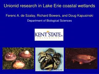
Unionid Distribution Within Nearshore Portions of 10 Streams in Northwest Ohio Trevor Prescott Cleveland State University Master of Science Candidate
Nearshore? • Estuaries/Flooded River Mouths • Attempted to get as close to the lake as possible • Private property • Businesses / Residential • Other access points
Streams • Western portion • Cedar Creek, Turtle Creek, Toussaint River • Central portion • Yellow Swale, South Creek, Raccoon Creek • Eastern portion • Plum Brook, Old Woman Creek, Cranberry Creek, Chappel Creek
Cedar Creek • Small riparian zone, incised banks • ~ 10 – 30 feet • Surrounded by agriculture • 50%+ canopy cover • CPOM, garbage, Corbicula • Generally hard, cobble substrate • 3 – 5 feet deep
Turtle Creek • Very small to no riparian zone, banks ~ 6 feet higher than stream • 10 feet of riparian at most on northern bank • Agriculture to south, marina to north • No canopy cover • Other life observed • Very soft substrate • 1 – 6 feet deep, wide open stream
Toussaint River • Similar to Turtle Creek but bigger • Surrounded by variety of landscapes • Recovering riparian, residential, agriculture • Wide river, slow current • No canopy cover • Soft, muddy substrate
Yellow Swale • Established, larger riparian zone • Residential areas outside of riparian • Canopy cover near banks • Wide stream, slow current • Soft muddy substrate with pockets of sand
South Creek • North = established riparian zone of trees and shrubs. • Muddier substrate than southern portion, not as muddy as Turtle or Toussaint • Diverse wildlife • Canopy cover near banks • South = Riparian of cattails and grass • 50/50 sand and mud substrate • No canopy cover • Residential outside of riparian zone
Raccoon Creek • Near/Under route 6 bridge • Area of mud and deposition (70/30 mud to sand) • To the north • 90 – 100% canopy cover • Similar to Cedar Creek • Allochthonous input • Hard substrate • Thinner stream
Plum Brook • Healthy, wide, gently sloping riparian on banks • Part of Erie co. metroparks • 3 substrate types • Hard, compact mud • Soft mud, vegetation covered • Soft mud, free of vegetation • Canopy cover near banks
Old Woman Creek • Gently sloping, wide riparian on banks • No agriculture near preserve, only residential • Canopy cover near banks • Soft muddy substrate • Healthy stream with diverse wildlife
Cranberry Creek • Generally thin riparian zone • Residential/agricultural to the upstream • Marina downstream • Culverted under route 6 • More compact, thin stream • Semi-compact, muddy substrate • “Medium softness”
Chappel Creek • Thin to no riparian • Shrubs, residential lawns backed up to creek upstream • Parking lot, thin riparian downstream • Variance in depth • Very little to no canopy cover • Unique substrate • Cobble, gravel over hard, muddy substrate • No mussels – live or dead
Generalities • Healthy tendencies • Wider riparian • Wider stream (bankfull width) • Less incision on banks • Less canopy cover • Less agriculture in close proximity
Future Work/Analysis • GIS • Analyze land use/cover patterns • Error-check sites • Problems • Scale of analysis – How far away from the stream should land use/cover be analyzed? • Topography? • Literature on small streams