Download
1 / 18
180 likes | 205 Vues
Learn how to identify weather patterns and front types to determine your location relative to the storm center. Find out about winds, clouds, temperatures, and precipitation associated with different fronts.

E N D
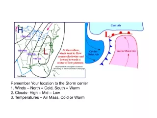
Remember Your location to the Storm center1. Winds – North = Cold, South = Warm 2. Clouds- High – Mid – Low 3. Temperatures – Air Mass, Cold or Warm
Convergence and Divergence Intensifying Surface Cyclone: For example, if a region of diverging winds at upper levels is stronger than the converging winds of a surface low pressure center below it, the low will deepen (intensify). Weakening Surface Cyclone: Storms fills itself
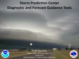
Weather Patterns & Fronts The five types of fronts are(1) warm front, which occurs when the surface (ground) position of a front moves so that warm air occupies territory formerly covered by cooler air, (2) cold front, where cold continental polar air actively advances into a region occupied by warm air,(3) stationary front, which occurs when the air flow on both sides of a front is neither toward the cold air mass nor toward the warm air mass,(4) occluded front, which develops when an active cold front overtakes a warm front and wedges the warm front upward, (5) a dryline, a boundary between dry, dense air and less dense humid air often associated with severe thunderstorms during the spring and summer. The two types of occluded fronts are the cold-type occluded front, where the air behind the cold front is colder than the cool air it is overtaking, and the warm-type occluded front, where the air behind the advancing cold front is warmer than the cold air it overtakes.
Warm Fronts Warm air rises1. Clouds2. Winds3. Temps
Warm Fronts Winds & Temps Warm SectorSouth/Southwest
Type of Clouds • Ci- Cirrus – High thin crystal like. First signs of warm air moving in • As- Alto Stratus- Mid level Blanket • More clouds, higher humidity
Type of Clouds • Nimbo/Nimbus -- Rain cloud, Dark gray. Steady all day rain/snow. • Clouds of Vertical Development - Cumulus and Cumulonimbus. They develop into towers or domes • Cumulonimbus – Thunderstorms, heavy rain
Cold Fronts *Fast Rising Air, Condensation, Clouds *Pressure falls, wind shift
Will it Snow or Rain? • Temperature Profile
Precipitation – Rain, Snow, Sleet, Freezing Rain • Temperature Profile of the Atmosphere.- Is it warm or Cold. Above 32 or below • Rain – All Layers above 32 • Snow – All Layers below 32 • Sleet – Cold, Warm, Cold Layers • Freezing Rain – Warm, Shallow Cold Air
Examples What type of Weather Remember Your location to the Storm center1. Winds – North = Cold, South = Warm 2. Clouds- High – Mid – Low 3. Temperatures – Air Mass, Cold or Warm
Precipitation – SNOW Snow – All Layers below 32 Degrees
Precipitation – Sleet Sleet – Cold, Warm Cold layers
Precipitation – (Glaze) Freezing Rain Freezing Rain – Warm, Cold Surface