Ordnance Survey & Ontologies
80 likes | 305 Vues
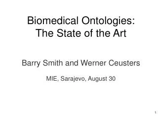
Ordnance Survey & Ontologies. Dr John Goodwin. Ordnance Survey and Linked Data. b. a. a. b. b. a. b. a. DC(a,b). PO(a,b). EC(a,b). EQ(a,b). b. a. a. b. TPP(a,b). TPPi(a,b). b. a. a. b. NTPP(a,b). NTPPi(a,b). Region Connection Calculus. disconnected (DC)

Ordnance Survey & Ontologies
E N D
Presentation Transcript
Ordnance Survey & Ontologies Dr John Goodwin
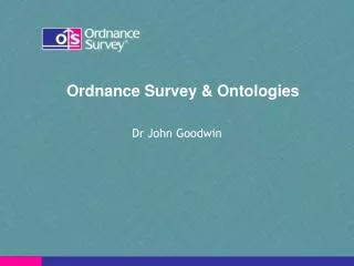
b a a b b a b a DC(a,b) PO(a,b) EC(a,b) EQ(a,b) b a a b TPP(a,b) TPPi(a,b) b a a b NTPP(a,b) NTPPi(a,b) Region Connection Calculus disconnected (DC) externally connected (EC) equal (EQ) partially overlapping (PO) tangential proper part (TPP) tangential proper part inverse (TPPi) non-tangential proper part (NTPP) non-tangential proper part inverse (NTPPi)
Spatial Relations DC Disjoint EC Touches EQ Equal PO Partial overlaps TPP Within TPPi Contains NTPP Within NTPPi Contains
Semantics in OWL propertyΟ equals → property equals Οproperty → property within Ο disjoint → disjoint disjoint Ο contains → disjoint partiallyOverlaps Ο within → overlaps contains Ο touches → connected Etc…
Administrative Geography ObjectProperty: inCounty SubPropertyOf: within Characteristics: Functional Range: County or GreaterLondonAuthority ObjectProperty: ward SubPropertyOf: contains SubPropertyChain: district o ward Range: UnitaryAuthorityElectoralDivision or Ward
Class: District SubClassOf: CivilAdministrativeArea, ward some DistrictWard, inCounty exactly 1 County
Geometry • Should complex geometries, e.g. Polygons etc. be stored in the graph? extent asGML Feature Geometry XML Literal Polygon Line Point