Download
1 / 55
590 likes | 712 Vues
Science and the Bible, Part 2: The Worldwide Flood. Genesis 7:6-12. James Barr , Oriel Professor of the interpretation of the Holy Scripture, Oxford University, England, in a letter to David C.C. Watson, 4-23-1984

E N D
Science and the Bible, Part 2: The Worldwide Flood Genesis 7:6-12
James Barr, Oriel Professor of the interpretation of the Holy Scripture, Oxford University, England, in a letter to David C.C. Watson, 4-23-1984 ‘… probably, so far as I know, there is no professor of Hebrew or Old Testament at any world-class university who does not believe that the writer(s) of Genesis 1–11 intended to convey to their readers the ideas that: • creation took place in a series of six days which were the same as the days of 24 hours we now experience; • the figures contained in the Genesis genealogies provided by simple addition a chronology from the beginning of the world up to later stages in the biblical story; and • Noah’s flood was understood to be world-wide and extinguish all human and animal life except for those in the ark.’
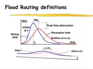
Source of the Great Flood • During the flood of Noah subterranean fountains persisted for 150 days. (Gen 7:11-24) • Spring water such as the famous Artesian Wells originate from ancient underground aquifers like the Ogallala aquifer, which spans 8 states in the US. • These buried waters are possibly a remnants of the fountains of the great deep that bursts forth during the Biblical flood. (Chris Ashcraft) Fountains of the Deep
In 1973, the TV personality and world- famous diver Jacques Cousteau said: “Were the crust of the earth to be leveled – with great mountain ranges like the Himalayas and the ocean abysses like the Mariana Trench evened out – no land at all would show above the surface of the sea. Earth would be covered by a uniform sheet of water – more than 10,000 feet deep! So overwhelming the ocean seems to be.” -- Cousteau, J., The Ocean World of Jacques Cousteau - Oasis In Space, Angus & Robertson (U.K.) Ltd. London, England, p.17, 1973
10,000 feet Earth Assuming mountains rose and deep ocean trenches deepened (as suggested by Ps. 104) towards the end of the flood (Gen. 8), the 10,000 feet of water some secular sources estimate would be plenty.
Psalm 104 (NASB95)6 You covered it with the deep as with a garment; The waters were standing above the mountains … 8 The mountains rose; the valleys sank down To the place which You established for them. 9 You set a boundary that they may not pass over, So that they will not return to cover the earth.
Christian geologists and creation scientists have suggested: • Today’s highest mountains formed toward the end and after the Flood • Tectonic plate collisions may have contributed to upthrusting • It is interesting that uppermost parts of Mt Everest contain fossil-bearing, water-deposited layers, including marine fossils near the peak
Several of the following slides are from an online presentation by Chris Ashcraft “Geology and the Flood of Noah” and other online presentations (Thomas Kindell, etc.) at below website: Northwest Creation Network http://nwcreation.net
Marine Fossils Everywhere Marine fossils are found on almost every mountain range in the world (Alps, Andes, etc.), and provide clear evidence that the oceans covered them and the continents at one time.
Source of the Great Flood The flood possibly began when the earth's crust was fractured releasing subterranean caverns of water and magma. Mid Oceanic Ridge / Lithosphere Plates
Mount St. Helens The eruptions at Mt. St. Helens were an important geological event for creation science. Rapid deposition and erosion occurred providing a model of the type of activity taking place during the great Biblical flood of Noah.
Phil’s non-inspired comment: We don’t know the extent of the seismic and volcanic activity described in Genesis 7:11 except to know that the breaking open of all these subterranean sources was an unprecedented and unrepeatable unique event on this planet. This destruction of God’s creation is not something scientists observe today anymore than God’s initial creation, and their objections can’t prove but can only assume uniformitarian naturalistic constants; i.e., things must continue as they have since the beginning, all changes are slow and there are no catastrophes like Genesis 7.
God’s inspired Word: 2 Peter 3:3-6 • ‘Scoffers will come in the last days with scoffing, following their own sinful desires. They will say, “… all things are continuing as they were from the beginning of creation.” For they deliberately overlook this fact … the world that then existed was deluged with water and perished.” (ESV)
What impact might this deluge have had? ‘In their catastrophic plate tectonics model for the flood, Austin et al. have proposed that at the onset of the flood, the ocean floor rapidly lifted up to 6,500 feet (2,000 meters) due to an increase in temperature as horizontal movement of the tectonic plates accelerated. This would spill the seawater onto the land and cause massive flooding—perhaps what is aptly described as the breaking up of the “fountains of the great deep.” … In the catastrophic plate tectonics model for the flood, volcanic activity associated with the breaking up of the pre-flood ocean floor would have created a linear geyser (like a wall) of superheated steam from the ocean, causing intense global rain.’ (www.answersingenesis.org )
Catastrophic Plate Tectonics: A Global Flood Model of Earth History By (In alphabetical order) Steven A. Austin, Ph.D. John R. Baumgardner, Ph.D. Institute for Creation Research P.O. Box 2667 El Cajon, CA 92021 USA 1965 Camino Redondo Los Alamos, NM 87544 USA Andrew A. Snelling, Ph.D. Creation Science Foundation P.O. Box 6302 Acacia Ridge D.D., Qld. 4110 AUSTRALIA D. Russell Humphreys, Ph.D. 9301 Gutierrez, N.E. Albuquerque, NM 87111 USA Larry Vardiman, Ph.D. Kurt R. Wise, Ph.D. Institute for Creation Research P.O. Box 2667 El Cajon, CA 92021 USA Bryan College P.O. Box 7585 Dayton, TN 57321-7100 USA
How did animals after the flood get to faraway islands, Australia, etc.? Encyclopedia Britannica (online edition): Six months after the eruption of a volcano on the island of Surtsey off the coast of Iceland in 1963, the island had been colonized by a few bacteria, molds, insects, and birds. Within about a year of the eruption of a volcano on the island of Krakatoa in the tropical Pacific in 1883, a few grass species, insects, and vertebrates had taken hold. On both Surtsey and Krakatoa, only a few decades had elapsed before hundreds of species reached the islands. Not all species are able to take hold and become permanently established, but eventually the island communities stabilize into a dynamic equilibrium.
Paul Taylor writes that the animals “could have floated on vast floating logs, left-overs from the massive pre-Flood forests that were ripped up during the Flood and likely remained afloat for many decades on the world’s oceans, transported by world currents. Others could later have been taken by people. Savolainen et al., have suggested, for example, that all Australian dingoes are descended from a single female domesticated dog from Southeast Asia. A third explanation of possible later migration is that animals could have crossed land bridges. This is, after all, how it is supposed by evolutionists that many animals and people migrated from Asia to the Americas—over a land bridge at the Bering Straits. For such land bridges to have existed, we may need to assume that sea levels were lower in the post-Flood period—an assumption based on a biblical model of the Ice Age …”
Michael Oard [retired scientist / Ice Age researcher] suggests that even with present topography, a number of significant land bridges would have existed to facilitate migrations if the sea level were only 180 ft below current levels. [Did the ocean level rise after the ice age and/or land bridges sink lower later?] However, there is even evidence that the land in some places where land bridges would be necessary could have been higher still. Thus, land bridges facilitated by the Ice Age constitute a serious model to explain how some migrations could have been possible. -- The New Answers Book, Chapter 11.
What’s more reasonable? An earthly flood or a catastrophic flood on the globe of the planet Mars?
“It is proposed that the rapid release of water under great pressure from deeply buried aquifers is responsible for the formation of the Martian channels suggestive of catastrophic flooding (outflow channels). Fine channels in the Martian surface suggest the presence of surface water early in the history of the planet, which would have entered the ground water system … High pore pressures within the aquifers are considered to have triggered the breakout of water from the aquifers at rates of from 10 to the 5th to 10 to the 7th cu m/sec … also considered to have caused the undermining of adjacent areas and the collapse of the surface to form areas of chaos, often associated with channels.” Journal of Geophysical Research, vol. 84, June 10, 1979, p. 2995-3007.
Continued: “It is here proposed that the large channels were eroded by water released rapidly, under great pressure, from deeply buried aquifers. Early in the planet's history the old cratered terrain was probably highly permeable to depths of several kilometers as a result of its volcanic origin … Extensive dissection [canyons, etc.] of the old cratered terrain by fine channels suggests that fluvial action was widespread at that time and that warmer climatic conditions prevailed. Much of the water which cut the fine channels was probably removed from surface circulation and entered the groundwater system … breakout of water from the aquifers could have been triggered either by impact or by the pore pressure reaching the lithostatic pressure … Outflow from the aquifer probably caused undermining of the adjacent areas and collapse of the surface to form chaos.” http://www.agu.org/pubs/crossref/1979/JB084iB06p02995.shtml
Reuters, “Mars Calamity May have Created Conditions for Life.” New York Times, 16 March, 2001. 'The total release of gases from Tharsis magma may have produced the equivalent of a global layer of water nearly 400 feet deep … At the very end of the Noachian epoch, volcanic activity dissipated and carbon dioxide and water were removed from the atmosphere by a combination of factors…'
“I propose that the megaflood … incised the crust more than 700 m, penetrated the cryosphere, and triggered the release of groundwater and genesis of secondary chaos zones … At the time of the flood the cryosphere thickness and groundwater depth would have been 700 to 1000 m at this location … of present day Mars.” -- Journal of Geophysical Research, Volume 110, Issue E12, 09/2005
A catastrophe “on Mars that produced a flood that the newspaper actually refers to as a 'Noachian‘ [dictionary = “relating to Noah or his time”] event.” There you have it—a veritable Noah's Flood occurred on Mars! • … Isn't it remarkable that this secular report has no problem talking about a 'Noachian' event (global flood) on Mars as a serious theory—but would scoff at the idea of a global 'Noachian' event on Earth! • These scientists are very happy to believe in a global flood on a planet that as far as we know has no liquid water at the present time, but scoff at even the mention of a global Flood on a planet (Earth) that is mostly covered by water!” http://www.answersingenesis.org/docs2001/0327news.asp
A Question of Logic How much liquid water has been found on Mars? None Three-fourths of the Earth is covered with water, over 7 miles deep Do evolutionists believe a worldwide flood occurred on Earth? No! Are they unable to believe or unwilling? (Read Romans 1)
Palouse Canyon in southeastern Washington which was eroded through solid basalt by Lake Missoula floods.. ((Photo by Steven A. Austin)
Geologic Processes The Little Grand Canyon of the Toutle River One Day Picture by Steve Austin, Ph.D. Geology
Geologic Processes Palouse Falls Gorge, WA
Geologic Processes Rapidly formed strata on the North Fork of the Toutle River
Mount Saint Helens Rapid canyon formation Rapid sedimentation
Canyon in 6-Days 500 meters long 40 meters deep Burlingame Canyon near Walla Walla, Washington
Catastrophism vs Uniformitarianism • Catastrophism - Prior to the 19th century it was largely assumed by geologists that catastrophes such as the Biblical flood were responsible for the majority of the earth’s fossiliferous rock. • Uniformitarianism - Around 1850 the non-catastrophic view of earth’s geology began to develop, which suggested that gradual processes and uniform intensities were instead responsible. Is the Grand Canyon evidence of a catastrophe or millions of years of erosion?
Bias Against Catastrophism In the 1920s Harlen Bretz proposed that features in eastern Washington must have been formed by flooding of catastrophic proportion. Channeled Scablands
The Missoula Flood Glacial Lake Missoula covered over 3,000 square miles of what is now western Montana, and was over 2,000 feet deep at the edge of the glacial dam.
Giant Ripples Rolling hills west of Spokane are actually giant ripples up to 30 feet high and 250 feet apart.
Harlen Bretz The Seattle Times - 2/10/2003Natural Wonders: Rock of Ages’ Roiling Tale “Mystified by the forces that could have exposed such massive features, Bretz set out in the early 1920s to solve the riddle. He returned with a hypothesis that was dismissed as near lunacy: in a region that sees less moisture in a year than Seattle gets in a month, Bretz concluded the entire landscape was carved by water.” “Bretz, according to some reports, was quickly isolated as a crank, while his critics' theories continued to make it into textbooks. Fifty years later, Bretz was hailed as a hero, and in 1979, at age 96, given geology's highest honor — the Penrose Medal, which rewards one researcher each year for exceptional contributions to geology.” “Two years later, he passed away.”
Bretz Dedication Placque Dry Falls Visitor Center
Rapid Strata Formation Touchet bedsMissoula FloodSlackwater Deposits Near Walla Walla, WA there are up to 40 distinct rhythmite layers exposed in the Burlingame Canyon, that were formed during the Missoula Flood. Burlingame Canyon
March 19, 1982 Rapid Strata Formation at Mt. St. Helens June 12, 1980 Stratified layers up to 400 feet thick formed as a result of landslides, air fall tephra, pyroclastic flow, and mudflows, during the Mt. St. Helens eruptions. May 18, 1980 Toutle River, Mt. St. Helens