Download

1 / 10
100 likes | 288 Vues
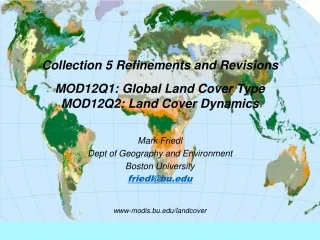
Collection 5 Refinements and Revisions MOD12Q1: Global Land Cover Type MOD12Q2: Land Cover Dynamics. Mark Friedl Dept of Geography and Environment Boston University friedl@bu.edu www-modis.bu.edu/landcover. MOD12Q1 Overview Global Land Cover Type. Thematic classification of land cover

E N D
Collection 5 Refinements and RevisionsMOD12Q1: Global Land Cover TypeMOD12Q2: Land Cover Dynamics Mark Friedl Dept of Geography and Environment Boston University friedl@bu.edu www-modis.bu.edu/landcover
MOD12Q1 OverviewGlobal Land Cover Type • Thematic classification of land cover • Five Classification Schemes • IGBP, UMD, LAI/FPAR, PFT, Biome-BGC • Internally consistent! • Second most likely IGBP class • Classification confidence • C4: Global, 1-km, annual (2001-2004)
MOD12Q2 OverviewLand Cover Dynamics • Global database • Twice per year • 12-month time periods • Includes 7 metrics • Onset of EVI increase, • Onset of EVI maximum, • Onset of EVI decrease, • Onset of EVI mimimum, • Min, max, & sum of growing season EVI • Collection 4 • Produced for 2001-2004 • Available on the LP DAAC Timing Annual Metrics
Extract Exemplars From STEP Database MOD12Q1: Summary of Key Changes Estimate Classification (Ensemble Decision Trees) • Revision of land cover training site database • Smaller, high quality sites (~1500) • More recent scenes (post-2000) • Input features • 8-day, 500-m NBAR data • aggregated to 32-day • EVI, LST (MOD11) • Annual Metrics • Updated “priors” layers • Based on MOD12 C4 • New global agriculture from inventory data Apply Classification to Global Data Fuse Results With Ancillary Data (post-processing) Maps
MOD12Q2: Summary of Key Changes • Temporal resolution • Using 8-day EVI • Spatial Resolution • 500-mNBAR inputs • Improved screening for snow • Using NBAR snow-flag in combination with LST (MOD11) • Identification and correction of several minor bugs in code.
Summary • Key Results from Changes • Improved spatial resolution (MOD12Q1, Q2) • Improved temporal resolution (MOD12Q2) • Fewer missing values (MOD12Q1, Q2) • Most importantly • Improved thematic quality for MOD12Q1 • Improved accuracy & precision for MOD12Q2 • Ongoing and Future Activities (C6) • Focus on problematic classes; FAO LCCS • Stabilization across years • Smoothing and interpolation (clouds) for MOD12Q2 • Validation for C5 versions of both products • Creation of 1-km and CMG for C5