Download

1 / 75
750 likes | 985 Vues
Applications of Aircraft Weather Data. American Meteorological Society Short Course San Antonio, Texas January 14, 2007. Applications in Field Forecast Offices. Rich Mamrosh – NOAA NWS Green Bay, Wisconsin. Applications in Field Forecast Offices. National Weather Service

E N D
Applications of Aircraft Weather Data American Meteorological Society Short Course San Antonio, Texas January 14, 2007 Applications in Field Forecast Offices Rich Mamrosh – NOAA NWS Green Bay, Wisconsin
Applications in Field Forecast Offices • National Weather Service • Warning and Forecast Offices • Center Weather Service Units • Storm Prediction Center
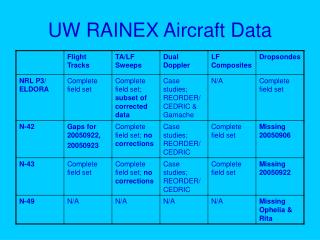
NWS Forecast Office Applications • Data Comparison (Radiosonde, Radar, Profilers) • Marine (Wind and Wave Forecasts) • Fire Weather (Haines Index, Mixing Heights) • High Wind Events (Santa Ana, Front Range, Synoptic) • Aviation (Ceiling, Visibility, LLWS) • Winter (Precipitation Type, Lake Effect Snow) • Convective Storms (Watch and Warning Decisions)
Data Comparison Wind Estimates from Doppler Radar Wind Profilers Commercial aircraft GOES and POES Satellites Radiosondes Numerical models
Data Comparison Radiosondes • The NWS in La Crosse, Wisconsin used TAMDAR to verify what looked to be erroneous radiosonde data. • The dewpoint from the Minneapolis, Minnesota radiosonde seemed way too low. • TAMDAR data showed that the radiosonde information was indeed correct. This was very important in determining what precipitation type was likely later that day.
Data Comparison Radiosondes AREA FORECAST DISCUSSIONNWS LA CROSSE WIAFDARX 401 AM CST MON NOV 1 2004 .SHORT TERM... THE NOVEMBER 1ST 00Z 850 MB DEW POINT OF -36C AT CHANHASSEN LOOKED INITIALLY SUSPICIOUS WHEN LOOKING AT TRAJECTORIES. HOWEVER...A MESABA AIRCRAFT WITH THE NEW TAMDAR SENSOR AT 04Z HAD A DEW POINT OF -32C IN THE CHANHASSEN AREA. THE ACCURACY OF THIS DEW POINT IS RATHER CRITICAL BECAUSE IT AFFECTS THE INITIAL ONSET OF PRECIPITATION…
Data Comparison Model Forecasts
Data Comparison Model Forecasts • Senior duty meteorologists at NCEP often use AMDAR flight level data to determine the validity of radiosonde winds and temperatures. Meteorologists in WFOs and CWSUs compare AMDAR to model initial analyses and forecasts. • The Lousiville, Kentucky NWS used AMDAR on May 17, 2005 to validate their suspicions that the NAM model dewpoints in the low levels were erroneous. • The boundary layer moisture was important in the fog forecast that night.
Data Comparison Model Forecasts AREA FORECAST DISCUSSIONNWS LOUISVILLE KYAFDLMK 940 PM EDT TUE MAY 17 2005 .UPDATE... HAVE NOTED VERY HIGH DEW POINT ERRORS IN THE RECENT RUNS OF THE ETA (NAM) MODEL. LOOKS AS THOUGH THE NAM HAD WAY UNDER-FORECAST THE MAGNITUDE OF THE DRY POCKET WITHIN THE DAYTIME BOUNDARY LAYER STRETCHING FROM THE OHIO VALLEY INTO THE MID-SOUTH THIS EVENING. AN ACARS DESCENT SOUNDING INTO EVANSVILLE AROUND 1Z SHOWED 950MB DEWPOINTS OF +4C...THE ETA HAD FORECAST +10 WITH THE GFS MUCH CLOSER AT +5C. WITH THAT SAID...OUR DEW POINT FORECAST WAS ON TARGET.
Marine Forecasting • A dense network of wind and temperature soundings are important to the production of accurate wind and waves forecasts. • Temperature profiles are important to determine stability (which affects mixing down of stronger winds aloft). • Wind profiles are needed to determine directional and vertical shear (which also affect transport of stronger winds aloft).
Marine Forecasting A dense network of radiosondes is not available near the oceans and Great Lakes.
Marine Forecasting • AMDAR observations have provided meteorologists with valuable supplemental data near the oceans and Great Lakes. • Forecasters have used AMDAR to issue, continue and discontinue Small Craft Advisories, Gale Warnings and Storm Warnings.
Marine Forecasting Gale Warning • The NWS in Grand Rapids, Michigan used AMDAR data in deciding to continue a Gale Warning for the nearshore waters of eastern Lake Michigan on November 6, 2005. • TAMDAR soundings from Kalamazoo, Michigan showed that there still were winds at nearly 50 knots in the lowest 3,000’ of the atmosphere. • In addition, the air was unstable, and the winds had little directional shear – both favorable for the transfer of strong winds to the surface.
Marine Forecasting Gale Warning GALE WARNING: A warning of sustained surface winds, or frequent gusts, in the range of 34 knots (39 mph) to 47 knots (54 mph) inclusive, either predicted or occurring, and not directly associated with a tropical cyclone. Map of NWS Grand Rapids forecast area. Nearshore marine area is in purple.
Marine Forecasting Gale Warning AMDAR data in Great Lakes region from 1400 to 1659 UTC on November 6, 2005
Marine Forecasting Gale Warning TAMDAR Sounding From Kalamazoo Showing West winds At 46 knots About 2,200’ AGL.
Marine Forecasting Gale Warning AREA FORECAST DISCUSSIONNWS GRAND RAPIDS MIAFDGRR 1032 AM EST SUN NOV 6 2005 5 MINUTE WIND DATA AT THE GLERL COAST SITES SHOWS THE WINDS HAVE PEAKED AT MKG...LWA AND MICHIGAN CITY IN THE PAST HOUR NEAR 45 KNOTS. THE TREND IS NOW DOWN SLOWLY ON THE WIND SPEED. TAMDAR DATA STILL SHOWS WINDS UNDER 5000 FT OF JUST UNDER 50 KNOTS OVER THE WESTERN CWA AT 10 AM. AS A RESULT OF ALL OF THAT I PLAN ON LEAVING THE GALE WARNING AND THE WIND ADVISORY AS IS INTO THE MID AFTERNOON.
Marine Forecasting Lake and Sea Breezes • AMDAR can provide the information to determine the likelihood of lake and sea breeze formation. • Lake and sea breezes are hindered by an offshore gradient wind, and enhanced by an onshore wind. Stability also plays a role.
Marine Forecasting Lake and Sea Breezes • Meteorologists at the NWS in Cleveland used AMDAR data on April 16, 2005 to forecast the formation and inland penetration of a lake breeze from Lake Erie. • AMDAR soundings showed that there were significant south (offshore) winds that would slow the formation of the lake breeze, and limit it’s inland movement. • In addition to it’s importance for mariners, this wind forecast also affects the large hub airport at Cleveland.
Marine Forecasting – Lake and Sea Breezes AMDAR sounding from 1244 UTC in the vicinity of Cleveland
Marine Forecasting – Lake and Sea Breeze AREA FORECAST DISCUSSIONNWS CLEVELAND OHIO1159 AM EDT SAT APR 16 2005 .UPDATED…SOUTH WINDS WERE INCREASING AND TEMPERATURES WERE RISING WITH FULL SUNSHINE. HIGHS SHOULD RANGE FROM 65 TO 70 DEGREES. THE LAKE BREEZE, IF IT DOES DEVELOP, SHOULD BE RIGHT ALONG THE LAKESHORE FROM NEAR CLEVELAND THROUGH ERIE. AMDAR DATA NEAR CLEVELAND WAS INDCATING THE WINDS FROM SOUTH AROUND 25 KNOTS AT 2,000 FEET.
Fire Weather • AMDAR data are becoming increasingly utilized by fire weather forecasters, as coverage expands across the U.S. • Useful fire weather forecasts are dependent on accurate observations and/or model forecasts of mixing layer heights, Haines indices, and surface relative humidity.
Fire Weather Smoke Dispersion • Smoke from prescribed burns and wildfires can cause serious problems for those with respiratory problems. It also can also cause accidents by reducing visibilities on highways. • The NWS produces a Smoke Dispersion index based mostly on model forecast soundings. These forecasts are used by fire weather agencies to determine whether prescribed burns should be allowed, and if wildfires might produce hazardous smoke conditions.
Fire Weather Smoke Dispersion • The Miami NWS used AMDAR to update smoke dispersion forecasts on May 2, 2005. • ACARS soundings showed very light winds (3-10 kts) in the mixed layer, which inhibits smoke dispersion.
Fire Weather Smoke Dispersion ACARS sounding From 1411 UTC On May 2, 2005 In the vicinity of Miami, Florida Shows very light Winds (< 10 kts) in the mixed Layer.
Fire Weather Smoke Dispersion AREA FORECAST DISCUSSIONNWS MIAMI FL1030 AM EDT MON MAY 2 2005 .FIRE...WILL AMEND GRIDS AND FWF. WINDS IN MIXED LAYER ARE FAIRLY LIGHT, WHICH IS CONFIRMED BY ACARS DATA. THIS WILL RESULT IN ADJUSTMENTS TO TODAY’S DISPERSION INDICES.
Fire Weather AMDAR inspired systems • The utility of AMDAR in fire weather forecasting fostered the development of locally driven efforts. • An experiment called HI-RISE (Hazardous Incident − Rapid In-flight Support Effort) was conducted in the spring of 2005 by the following participants • National Weather Service • Texas Forest Service • USDA Agricultural Station • Aventech Research Inc.
Fire Weather AMDAR inspired systems HI-RISE involved the installation of meteorological instruments on a small fire surveillance aircraft, and downlinking the data in real time to meteorologists. AIMMS-20 instrumentation Air Tractor AT-402B aircraft used in HI-RISE Data flow in HI-RISE experiment* D
Fire Weather AMDAR inspired systems Non-commercial aircraft such as these can fly REALLY close to fires and measure meteorological parameters vital in forecasting fire behavior Air Tractor AT-402B aircraft flying over Texas Forest Service ground crew during HI-RISE experiment
Fire Weather AMDAR inspired systems Example of aircraft sounding from HI-RISE fire weather experiment. Notice highly detailed temperature, moisture and wind data.
Fire Weather AMDAR inspired systems • This proof of concept experiment provided valuable real time data to fire weather forecasters at controlled burns in central Texas. • All of the participants agreed that this concept should be developed further for fire weather and other applications, including HAZMAT support. HI-RISE Team from NWS, USDA, Texas Forest Service and AVENTEC
High Winds • Non - convective high wind events occur over the entire country. • Meteorologists largely rely on model forecasts to issue high wind watches, and a combination of observations and model data to issue warnings. • The lack of real time upper air data can make warning decisions difficult.
High Winds • Downslope high wind events occur with some regularity in the Rocky Mountain region. • Santa Anna winds in California and strong winds along the front range in Colorado are two well known phenomena that are forecast challenges.
High Winds Schematic of Santa Ana winds in southern California
High Winds Santa Ana • A Santa Ana wind event occurred the night of December 22-23, 2006 in southern California. • Meteorologists at the NWS in San Diego monitored AMDAR soundings during the early morning hours, and decided to upgrade a wind advisory to a high wind warning based on AMDAR soundings.
High Winds Santa Ana AREA FORECAST DISCUSSIONNWS SAN DIEGO CA1120 PM PST FRI DEC 22 2006 .DISCUSSION... UPDATE TO UPGRADE THE WIND ADVISORY FOR THE INLAND EMPIRE AND THE SANTA ANA MOUNTAINS AND FOOTHILLS TO A HIGH WIND WARNING THROUGH EARLY AFTERNOON SATURDAY. RECENT ACARS SOUNDINGS FROM ONTARIO SHOW A VERY IMPRESSIVE SUBSIDENCE INVERSION NEAR 700 MB FAVORABLE FOR MOUNTAIN WAVE DEVELOPMENT AS WELL AS AN OVERALL STRONG WIND FIELD BELOW 700 MB WITH WINDS UP TO 50 KNOTS OR SO. WINDS IN THE WINDIER LOCATIONS...BELOW THE CAJON PASS AND NEAR FREMONT CANYON HAVE GUSTED TO AROUND 60 MPH IN THE PAST HOUR.
High Winds Santa Ana AMDAR sounding at 0411 UTC December 23, 2006 from Ontario, California showing mountain top inversion and strong wind field.
High Winds New York City • A High Wind event driven by an intense cyclone occurred in the Northeast on November 13, 2003. • The NWS in Upton (Long Island), New York used AMDAR data to monitor winds aloft in real time, and made warning decisions based on these data. • The upstream data at the New York area airports was especially valuable.
High Winds New York City Surface weather map from November 13, 2003 shows strong cyclone over southern Quebec
High Winds New York City • AREA FORECAST DISCUSSION • NATIONAL WEATHER SERVICE UPTON NY • 1000 AM EST THU NOV 13 2003 . • DISCUSSION... .UPDATE...SEVERAL REPORTS OF DOWNED TREES/DAMAGE AND WINDS AS HIGH AS 52 KT AT AMBROSE LIGHT. HIGHEST LAND BASED WIND IS 48 KT AT LGA. EXAMINATION OF 12Z ACARS WINDS REPORTS SHOWS THAT 09Z RUC WINDS ARE TOO LOW AND THAT EVEN 06Z ETA WINDS ARE FEW KNOTS BELOW OBSERVED. AS COLD ADVECTION WORKS IN THIS AFTERNOON...HIGHER LEVEL WINDS WILL WORK DOWN TO SURFACE. USING A 90% RULE OF WINDS ALOFT...RESULTS IN PEAK SURFACE OF 60 KT OR 70 MPH. WILL HEADLINE...WIND GUSTS TO NEAR HURRICANE FORCE.
High Winds New York City 12UTC sounding From Brookhaven New York shows 60+ knot winds Within 2,000’ AGL.
High Winds New York City 1243 UTC AMDAR sounding from JFK airport shows 51 knot winds around 2400’ AGL.
High Winds New York City 1433 UTC AMDAR sounding from Newark, NJ shows 63 knot winds around 3000’ AGL and an almost dry, adiabatic lapse rate.
High Winds North Dakota AREA FORECAST DISCUSSIONNWS GRAND FORKS ND340 AM CST SUN DEC 17 2006 .SHORT TERM (SUN-TUE)...AMDAR SOUNDINGS AT 05Z FOR DVL/JMS SHOWED THAT MORE COLD ADVECTION HAD OCCURRED AT 850 MB THAN MODELS ANTICIPATED WHILE LOW LEVEL WINDS WERE STRONGER TOO. THE COLDER CONDITIONS HAVE KEPT THE BOUNDARY LAYER MORE MIXED AND WINDS ARE ABLE TO MIX THROUGH A BIT EASIER. JMS SHOWED 70 KNOTS AT 801 MB (JUST ABOVE THE INVERSION) AND DVL SHOWED 50 AT 911 MB. THESE WERE 10 TO 25 KNOTS HIGHER THAN MODEL SOUNDINGS.
High Winds North Dakota TAMDAR sounding from 0509 UTC in the vicinity of Jamestown, North Dakota on December 17, 2006 shows 70 knot winds at 801 mb.
Aviation Forecasting Ceiling and Visibility • Meteorologists at the NWS San Diego office are one of the biggest users of AMDAR data in the United States. The scarcity of upstream data, varied terrain, and a maritime influence make the availability of frequent upper air data very useful. • The data are especially useful to monitor the depth of the marine layer, upon which the formation and inland penetration of low clouds and fog are dependant upon.