Comprehensive UW RAINEX Aircraft Data Set with Satellite and Ground Radar Integration
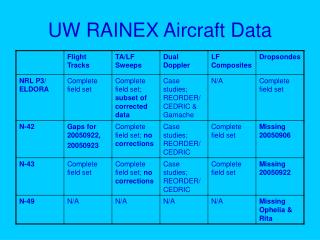
The UW RAINEX Aircraft Data Set encompasses vital environmental data captured through satellite imagery (GOES) in both 1km and 4km netCDF formats, alongside ground radar data, including NEXRAD composites. This data set covers a latitude range of 10 to 39.2 degrees and longitude from -95 to -45.2 degrees, providing detailed analyses and forecasts (up to 8 times at 3-hour intervals). It includes essential meteorological variables such as RAINR_INST, SLT, winds, temperatures, and numerous others, vital for storm analysis and forecasting.

Comprehensive UW RAINEX Aircraft Data Set with Satellite and Ground Radar Integration
E N D
Presentation Transcript
UW RAINEX Data Set • Satellite – GOES; 1km & 4km netcdf format • Ground radars – netcdf format • NEXRAD composites • Model – netcdf; alt: 0.03-18.6 km; lat:10 to 39.2 deg; lon: -95 to -45.2 deg • Between storms – analysis (1 time); forecast (8 times, 3hrly); RHL, RHI, RAINR_INST, SLP, TPRESSURE, U, V, W, TSEASFC • MM5_CMC • MM5_GFDL • MM5_GFS • MM5_NOGAPS • Periods of interest – analysis (1 time); forecast (8 times; 3hrly); RAINR_INST,CARTVRVTAN,CARTVRVRAD,U,V,WSPD,T,Q,QTOTAL,CLW,RNW,ICE,SNOW,GRAUPEL,W,THETAE,RHL,RHI,POTTEMP,PVORT,MPVORT,TPRESSURE,DBZ,TV,SLP,GHT,GHTW,ZAVORT, ZRVORT,XAVORT,XRVORT,YAVORT,YRVORT • MM5_CMC • MM5_GFDL