IRIS: Iowa Rivers Information System
Ecoregions. Landcover. Rivers. IRIS. Watersheds. Land Stewardship. Using National Hydrography Dataset (NHD) Two phases of development: Phase I – Reach based inventory Phase II – Dynamic Segmentation model Linkages by reach to other attribute databases.

IRIS: Iowa Rivers Information System
E N D
Presentation Transcript
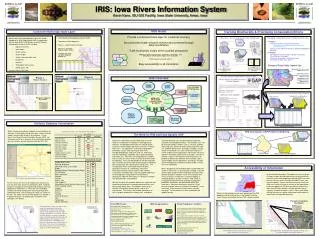
Ecoregions Landcover Rivers IRIS Watersheds Land Stewardship • Using National Hydrography Dataset (NHD) • Two phases of development: • Phase I – Reach based inventory • Phase II – Dynamic Segmentation model • Linkages by reach to other attribute databases Watershed / Stream Bio-prediction General Approach Developing a Digital Data Layer of Valley Segment Types • Purpose • Delineate distinct stream environments • Evolutionary and Ecologically Meaningful Units(See EDUs below) • Serve as the habitat template for predicting biological potential • Protocol • The Nature Conservancy’s Aquatic Community Classification Framework • Based on Ecoregions and Watershedsaka EcoDrainage Units (EDUs) Step 1. Classify Iowa’s riverine resources into distinct valley segment types Step 2. Assess the relative conservation status of each valley segment type and develop initial conservation priorities (quality and quantity) NHD Step 3. Predict the biological potential of each valley segment Example of Distinct Valley Segment Type Step 5. Identify valley segments which are both biologically significant and of relatively high quality Step 4. Revise initial conservation priorities using biological information * Ecoregion: Des Moines Lobe * Basin: Des Moines * River Size: Medium * Structure: Unconfined valley * Flow: Perennial * Temperature: Warm * Gradient: Moderate * Substrate: Fine * Hydrograph: Stable Phase II Dynamic Segmentation IRIS Overview Phase I Reach Based Example Species Habitat Affinity Database (MO) Begin Reach Begin Sample End Sample End Reach Percent Cropland By Reach The Need for IRIS and Iowa Aquatic GAP Iowa Rivers Information System (IRIS) focuses on the need for a comprehensive database relating physical, chemical, and biological information on a broad spatial scale to in-stream habitat and fishery resources in interior Iowa rivers. The approach is to develop a geographic information system (GIS) focusing on Iowa rivers incorporating geology, land cover and use, watershed, channel morphology, hydrology, water quality, biological information, etc. Numerous existing databases available from a variety of sources and in a variety of formats will be incorporated. These existing databases will be integrated into a common GIS format tailored specifically for exploring data relationships with specific points along rivers. The resulting Iowa Rivers Information System enables quantitative analysis of a tremendous amount of information covering a broad spatial scale, facilitate visualization of relationships using the graphic flexibility of the GIS approach, and provide the framework to continuously add new information as it becomes available from data providers and fieldwork. IRIS will first be used to explore differences in physical and chemical characteristics associated with Iowa rivers and among sites within rivers. The Nature Conservancy’s Aquatic Classification System will be used for this classification. This analysis will provide quantitative as well as graphic comparisons among rivers, ecoregions, and large drainage units and will help focus potential research and management efforts. For example, rivers will be characterized by variables such as sinuosity, gradient, watershed area, percent of watershed by land cover and use, wooded riparian zone, discharge variability, average nitrate concentration, etc. Sites for detailed study of in-stream habitat and fish populations will then be chosen to represent the broad ranges of these variables. Results of previous studies in the literature will provide a basis for predicting relationships between these variables and in-stream habitat and fish populations, providing a valuable interim management tool before detailed studies in Iowa rivers are completed. IRIS is designed to accommodate data from detailed field studies in Iowa rivers as they become available. Inclusion of these data will permit direct evaluation of relationships between database variables and in-stream habitat and fishery resources in Iowa rivers as well as building a standard database of Iowa river data. IRIS will be an exceptionally powerful tool for directing management, protection, restoration, and educational efforts with Iowa rivers. Questions as broad in scope as, “Does percent in-stream cover vary between ecoregions?”, or as narrow as, “Does percent in-stream cover vary with sinuosity?” can be answered in both quantitative and graphic formats. IRIS Cooperators: Percent Cropland By Reach IRIS: Iowa Rivers Information System Kevin Kane, ISU GIS Facility, Iowa State University, Ames, Iowa Consistent Hydrologic Base Layer IRIS Goals Tracking Biodiversity & Prioritizing Conservation Efforts Provide a consistent base layer for locational accuracy Document the health of Iowa’s riverine environments through data coordination Track biodiversity locally within a global perspective Helping to direct management, protection, restoration, and educational efforts within Iowa’s river resources Prioritizing conservation efforts Easy accessibility to all information • Build a consistent hydrologic base layer (the spatial database) for IRIS (and Aquatic GAP) in cooperation with the Iowa DNR's GIS Section using the National Hydrographic Dataset (NHD) including: • coding stream IDs, • watersheds, • stream names, • stream length, • stream route and order, and • boundaries, • counties, • TRS (public land survey), • USGS quads, etc. • for every reach in the state. IRIS Predicting the Biological Potential of each Valley Segment Statewide Known Distributions by Hydrologic Unit Valley Segment Data layer Attribute Database Coordination Habitat Affinity Database When the idea of creating a statewide stream database for Iowa was first being discussed there were several existing models we were able to look at for guidance. One of theses, the Illinois Stream Information System (ISIS), was extremely useful for us because of the similarities between our river systems and our familiarity with the ISIS staff. IRIS and Aquatic GAP Predictive Modeling Comparison of ISIS, IRIS and Aquatic Gap Attributes Classifying Rivers Watershed Influence to Habitat Predictive Model Historic and Sampled Distributions Habitat Affinity Databse Accessibility of Information of dissemination through a CD product was the way to go. As time has gone by and map serving via the internet has matured, we are now proposing to provide IRIS users with on-line, real time access through an ArcIMS Server (see figure left below). Access via the internet map server will allow users to have the latest versions of the data without relying on updates to CDs plus the ability to analyze the data using GIS tools without having to purchase costly software. Predefined queries such as those show below will help novice users gather information from the data to make timely management decisions. IRIS interface showing attributes as themes For this reason, the first set of attributes per reach on our wish list were those that were collected for ISIS. Attributes needed to complete Iowa’s Aquatic Gap Analysis were also added to our collection list. These two sets of attribute variables were then compared to what had already been collected for IRIS. Those comparison tables are shown to the left. The official start of the IRIS project has allowed us to begin the process of attributing the new NHD reach coverages (see below). When first envisioning how we were going to get the IRIS database into the hands of users, we thought using the Illinois Stream Information System (ISIS - above) method The IRIS Team: Kevin Kane, IRIS Coordinator, Co-PI ISU GIS Facility, ISU, kkane@iastate.edu Clay Pierce, Co-PIDept. Animal Ecology, ISU, cpierce@iastate.edu Robin McNeely, IRIS Attribution, IRIS Base Layer Dept. Animal Ecology, ISU, mobes@iastate.edu Patrick Brown, IRIS User Interface, IRIS Base Layer ISU GIS Facility, ISU, patrickb@iastate.edu Aquatic Habitat BiologistDept. Animal Ecology, ISUPlease visit the following webpages for more information about Aquatic Gap Analysis: IRIS and Aquatic GAP - mombasa.gis.iastate.edu/iris/iris.htmIowa Gap Analysis - www.iowagap.iastate.eduNational Gap Analysis - www.gap.uidaho.edu/gap Final Products / Credits:The Iowa Aquatic Gap Analysis Program will publish a final report explaining the biodiversity status of breeding aquatic species in the state. In conjunction with this biodiversity analysis, an atlas of land cover and the rivers database will also be published. The documents will be available on CD and on the Iowa Aquatic GAP website in Adobe Acrobat .pdf format. The GIS datasets used to create the land cover, stewardship and aquatic species layers will be available for downloading via ftp service. This same GIS data will be available for interactive viewing and querying over the Internet using ESRI’s Internet Map Server software. Credits: Missouri Resource Assessment Partnership National Gap Analysis ProgramIllinois Stream Information SystemIowa Dept. of Natural ResourcesIowa State University These two figures show examples of the initial IRIS attributions that will be completed for all Iowa watersheds by stream reach (attributes from the table circled in red above). On the left, each of the NHD reaches has been assigned a stream order by spatial conflation with the DNR’s stream order coverage. On the right, each reach is evaluated by the percent of deciduous forest within 90m of the reach. IRIS will use the completed Iowa GAP landcover map for this type of analysis for all landcover types. IRIS ArcIMS interface showing river attributes (http://siberia.gis.iastate.edu/iris) IRIS application showing percent cropland per reach and inset with orthophoto and GAP landcover