Download
1 / 69
700 likes | 1.1k Vues
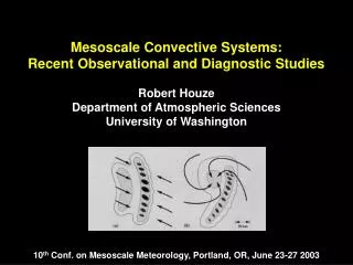
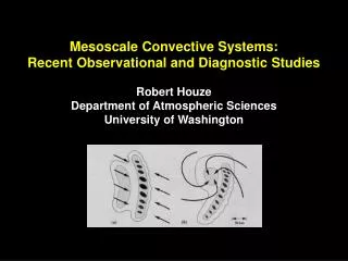
Factors Affecting Mesoscale Convective System Propagation with Illustrations from Case Studies. James T. Moore and Charles E. Graves Cooperative Institute for Precipitation Systems Saint Louis University Dept. of Earth & Atmospheric Sciences (with tweaks by SMR). Modes of Propagation 1

E N D
Factors Affecting Mesoscale Convective System Propagation with Illustrations from Case Studies James T. Moore and Charles E. Graves Cooperative Institute for Precipitation Systems Saint Louis University Dept. of Earth & Atmospheric Sciences (with tweaks by SMR)
Modes of Propagation 1 • Discrete propagation • Development of new cells • Produced from enhanced convergence in the boundary layer • Caused by downdrafts from the main storm • New cells typically form 4-10 km away from the main storm • Increases total storm area • Multicellular storms (socialist approach)
Modes of Propagation 2 • Continuous propagation • newly formed cells (and associated updrafts) continuously feed the main updraft of the primary storm (maintenance) • (cf. discrete propagation new development) • Supercell storms (capitalist approach)
Modes of Propagation 3 • Forward propagation • new cells form downstream from existing convection • Regenerative • new cells form in thesame location • move in the same direction as the earlier cells • Backward propagation • new cells form upstream from the existing convection • During regenerative/backward-propagating convection: • cells tend to move repeatedly over the same area • echo training, a serious heavy rainfall threat • MCSs can exhibit different propagation types during its lifetime
Forward Propagating MCS Rod Scofield, NESDIS
Favorable Environmental Conditions for • Forward-Propagating MCSs 1 • Maximum CAPE values coincident with MCS and extend downstream • 850 hPa e ridge extends northward toward and downstream from MCS location • Moving frontal or outflow boundary • Moderate-strong 850-250 hPa mean winds that have a significant cross-frontal component toward warm air • Moderate-strong thickness gradient with little/no diffluence
Favorable Environmental Conditions for • Forward-Propagating MCSs 2 • Low-level jet (LLJ) coincident with MCS location • LLJ veers with time as dictated by motion of short-wave trough • “Progressive” short-wave trough, translating eastward • 250-300 hPa upper-level jet is oriented west-east and positioned north of MCS • Strongest LL moisture transport/convergence located near and downstream from MCS location
Forward Propagating MCS Severe Convective Storms Monograph (AMS 2001) Chapter 12
Backward Propagating MCS Rod Scofield, NESDIS
Favorable Environmental Conditions for • Backward-Propagating/Regenerative MCSs 1 • Maximum CAPE values are coincident with and upstream from MCS location (typically to the W-SW) • 850 hPa e ridge extends northward and upstream from MCS location • Quasi-stationary west-east surface boundary (old front, outflow boundary, cloud boundary, etc.) • Weak 850-250 hPa mean winds with slight component directed toward the cold air
Favorable Environmental Conditions for • Backward-Propagating/Regenerative MCSs 2 • LLJ: • quasi-stationary and directed upstream from MCS location • LLJ nearly normal to surface boundary • diurnally-forced, veers inertially with time • Diffluent thickness pattern for 850-250 hPa layer • Typically a mid-tropospheric ridge aloft (indicative of weak winds) • Winds veer and strengthen with height (up to ~1.5 km/850 hPa) and weaken above with little veering (especially in the warm season) • Strongest low-level moisture transport/convergence at and upstream from MCS location • Quasi-stationary area of upper-level divergence (most MCSs form to the S-SW of the maximum upper-level divergence)
Characteristics of Backward-Propagating Regenerative Convection • Regenerative Convection: • Often near or within the upper ridge; relatively weak flow • Steering flow carries new echoes slowly away from regeneration area • Watch for intersection of low-level jet with pre-existing boundary and storm-generated boundary • Consider whether regeneration will be fast enough to balance cell movement • An approaching shortwave causes surface pressure falls, which helps enhance local low-level flow that supplies the storm Mean flow (Kelsch 2001)
Backward-Propagating/Regenerative MCSs Severe Convective Storms Monograph (AMS 2001) Chapter 12
Factors Associated With Warm-Season Training Events • Weak mid-upper level wind shear • Low-level jet normal to the upper-level jet • Weak low pressure circulation anchored west of the region of heavy rain • Moderate-high CAPE values (>2000 J kg-1) south of the region of heavy rain • Slow-moving training echoes • PW values > 130% of normal • Diurnally varying moderate low-level jet (>30 kt) • Often weak short-wave trough upstream of the region of heavy rain
Maddox “Frontal Type” Heavy Rain Scenario 1 Annual Distribution Surface conditions Maddox et al. (1979)
Maddox “Frontal Type” Heavy Rain Scenario 2 850 hPa Flow 500 hPa Flow Maddox et al. (1979)
Factors Associated With Cool Season Training Events • Moderate-strong wind shear in mid-upper troposphere • LLJ parallel to the upper-level jet • Weak low pressure center along a quasi-stationary frontal boundary • Weak CAPE (< 1000 J kg-1) • Fast-moving training echoes • Precipitable water (PW) values over 200% of normal • Strong persistent LLJ (> 50 kt) • Persistent long wave trough west of heavy rain region
Maddox “Synoptic Type” Heavy Rain Scenario 1 Annual Distribution Surface conditions Maddox et al. (1979)
Maddox “Synoptic Type” Heavy Rain Scenario 2 850 hPa Flow 500 hPa Flow Maddox et al. (1979)
Storm-Scale Effects on Propagation 1 • Internal mechanisms: • Storm Rotation • rotation (in supercells) non-hydrostatic perturbation low pressure updraft • Interaction of Updraft w/Env. Vertical Wind Shear • non-hydrostatic perturbation high on upshear side of storm downdraft • non-hydrostatic perturbation low on downshear side of storm updraft
Storm-Scale Effects on Propagation 2 • Internal mechanisms: • Outflow Boundaries • enhance low-level convergence/vertical motion • leads to new convection in preferred zones • Cold Pools • induces horizontal circulation • interaction of CP circulation with VWS circulation enhances lift in preferred zones
Environmental Effects on Propagation 1 • External mechanisms: • Low-level jet (LLJ) • often dictates location of preferred low-level convergence and new cell generation • key to the Corfidi (Vector) Method. • Synoptic-scale Boundaries • orientation and strength of boundary influences location of new convection • Magnitude/orientation of LL e ridge axes • convective instability • high moisture
Environmental Effects on Propagation 2 • External mechanisms: • Magnitude/orientation of system-relative LL moisture convergence • determines preferred regions of new convection • good as short-term forecast tool • Regions of instability and lids • new convection preferred in regions of high CAPE and low convective inhibition CIN (weak lid or “cap”) • modest cap needed to prevent premature ‘firing’ of convection
Gust Front Conceptual Model • Leading edge of LL thunderstorm cold outflow • Outflow depth ~1 km • Forced ascent at head (Droegemeier and Wilhelmson 1987)
Cold Pool/Low-Level Wind Shear Balance (after Rotunno et al. 1988) • Little/no LL VWS: gust front moves away from storm storm dissipates • LL VWS balances gust front optimal for cell propagation and long-lived systems
Non-Hydrostatic Perturbations Pressures Due to Rotation (e.g., HP supercells) L L • Development of positive and negative centers of rotation (via tilting of vortex tube by updraft) • negative perturbation pressures • enhanced UVM to north and south of storm • cell splitting L L (Klemp 1987)
Non-Hydrostatic Perturbation Pressures Due to Vertical Wind Shear Interacting with Storm-Scale Updraft H L H Straight-line hodograph: forward propagation L • Interaction between VWS and storm’s updraft: • perturbation highs/low • enhanced UVM • altered propagation H L H L Clockwise-turning hodograph: rightward propagation L H (Klemp 1987)
Corfidi’s “Vector Method” for MBE Movement • Where: VMBEMBE motion vector • VCLmeancloud-layer wind flow (850-300 hPa) • VPROPpropagation vector (= -VLLJ) • Use upstream LLJ vector to approximate inflow into MCS (Corfidi et al. 1996)
Original “Corfidi Vector Method” for Upwind-Propagating MCSs (Corfidi 2002)
Echo training (episodic MCSs) Quasi-stationary (upwind propagating) MCSs Hybrid MCSs
Modification to the “Vector Approach” • Corfidi (2003) noted similarities between environments of back-building convection and bow echoes/derechoes • bow echoes are distinctly forward propagators • opposite of back-building convection • Forward propagation favored by the presence of unsaturated air ahead of the developing MCS. • mid-levels or sub-cloud layer • strong downdraft potential strong mesohigh forms • mesohigh maximizes system relative convergence downstream of MCS • main threat from strong straight-line winds • Quasi-stationary/back-building MCSs are associated with (nearly) saturated lower troposphere • main threat from +RA/flash flooding
Idealized Plan View of Temporal Elongation of Cold Pool/ Gust Front in Largely Unidirectional Environmental Flow
Updated “Corfidi Vector Method” for Upwind- and Downwind-Propagating MCSs (Corfidi 2002)
Thermodynamic profile supportive of upwind propagation: • Unidirectional VWS • “Skinny” CAPE • Moist profile throughout • Thermodynamic profile supportive of downwind propagation: • Unidirectional VWS • “Fat” CAPE • Dry mid-level air (Corfidi 2002)
Summary Schematic: Similar Wind Profiles, Different Gust Front-Relative Flows Top: Quasi-stationary/backward propagating MCS--preferred inflow and new cell development on upwind end of MCS (flash flood threat). Bottom: Forward propagating MCS (bow echo)--new cells develop on leading edge where rear inflow jet converges with SR inflow (wind damage threat; FF threat exists if rainfall rates are high and if trailing stratiform precipitation exists.
Weak Mesohighs and Backbuilding • Weak mesohighs associated with: • Modest positive pressure anomalies slightly greater than ambient pressure, leading to weak isallobaric flow • Weak ambient surface flow (< 10 m s-1) • High mean surface-500 mb RH • reduced ability to form strong convective downdrafts • low DCAPE (downdraft CAPE) • Weak mid-level (~700-500 hPa) flow • limited downward vertical momentum transfer • weak convective downdrafts and weak momentum (see above) • System-relative inflow: • from the south-southwest for +RA-producing MCSs • surface outflow boundary does not move downstream • from the east-southeast for fast-moving bow echoes • surface outflow boundary moves quickly downstream
Veering winds + deep moist layer = heavy rain (esp. noted in elevated thunderstorms) Unidirectional shear + dry mid-layer air = bow echo/derecho (Miller 1978)
Categories for Midwest 1993 Heavy Rainfall Events (Junker et al. 1999)
Length of Moisture ConvergenceAxis Junker et al. 1999
Surface Analyses for 26 July 1998 06 UTC 09 UTC Indicates thunderstorm or heavy rain
IR Loop from 1815 UTC 25 July to 1515 UTC 26 July 1998: Forward Propagation
24 hour rain gauge analysis for the period ending 12 UTC 26 July 1998
Corfidi Vector Method: Downwind Approximation Corfidi Vector Method: Diagnostic Approximation Corfidi vectors worked well for forward propagation across Kansas
900-800 hPa Average Moisture Convergence: 03 UTC 26 July 1998 X
900-800 hPa Average Moisture Convergence: 06 UTC 26 July 1998 X
900-800 hPa Average Moisture Convergence: 09 UTC 26 July 1998 X
GOES-8 Infrared Satellite Loop for 1815 UTC 6 May to 1815 UTC 7 May 2000: Regenerative Convection
Prognostic and Diagnostic Corfidi Vector Diagrams Valid 0600 UTC 7 May 2000 FORECAST ACTUAL Gagan (2001)
24-Hour Precipitation Analysis for the Period Ending 1200 UTC 7 May 2000