Download
1 / 12
120 likes | 219 Vues
Explore the intelligent Sensorweb concept, merging diverse assets for real-time monitoring and improved hazard response in Earth Science. Discover tailored observations, optimized model runs, and advanced weather predictive systems.

E N D
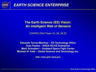
EARTH SCIENCE ENTERPRISE The Earth Science (ES) Vision:An intelligent Web of SensorsIGARSS 2002 Paper 02_06_08:20 Eduardo Torres-Martinez – ES Technology OfficeGran Paules – NASA HQ ES EnterpriseMark Schoeberl – Goddard Space Fight Center Michael W. Kalb – Global Science and Technology Inc. http://esto.gsfc.nasa.gov
On-boardProcessing “Network”Communications Sensor Platforms Real-time CollaborativeBehaviors CommonInterfaceLanguages Sensorwebs for Earth Science • A sensorweb is a virtual organization of multiple sensors combined into an intelligent ‘macro instrument’ such that information collected by any one sensor can be used by other sensors in the web, as necessary to accomplish a coordinated observing task.
Ln/Geo/HEO TDRSS & Commercial Satellites Far-Space Permanent LEO/MEO Commercial Satellites and Manned Spacecraft Near-Space Aircraft/UAVs Balloons Sondes Airborne Temporary Surface User Community Forecasts & Predictions Sensorwebs are the Observing Componentof an End-to-end Architecture
ES Development of the Sensorweb Concept • Precursor applications: • Landsat-7 and EO-1 are formation-flying platforms that perform coordinated research and applications observations. • The Aqua (05/02), Aura (01/04), Parasol (04/04), Cloudsat (04/04), and Calipso (04/04) platforms will become a formation-flying “train” that performs correlative research measurements.
Far-term Sensorweb Applications • ES Vision concepts include sensorwebs as enabling elements for systems that: • Automatically implement optimized observation strategies for weather and climate predictive systems such that the useful range of forecasts would be extended. • Automatically optimize the allocation of diverse assets for observations needed to predict; detect; and monitor the development certain natural hazards such that we can better mitigate the effects of such hazards.
TailoredObservations OptimumizedModel Runs ImprovedForecasts Advanced Weather Predictive System • By introducing a feedback path between a forecast model and a sensorweb-based observing system, future observations could be tailored to the specific data acquisition needs identified by the forecast model. • This approach applies the flexibility of the sensorweb to enable observing strategies that produce special data sets when and where it makes sense to have the highest impact on the forecast model run.
Focused Observations • Processed Information • Event Guidance • M/DA System • Data Analysis & Assimilation • Numerical Integration • Model Performance Assesment • SensorWeb • Terrestial-based Network • Space-based Network • Meteorological Context • Operational Directives Weather Predictive System ‘Control Loop’
Real-timeMonitoring Reliable Warnings Loss / Damage Forecasts ImprovedHazard Response Advanced Hazard Management System • Sensorweb-enabled observations linked with predictive models would provide reliable hazard warnings and monitor events to provide real-time data setsneeded to drive decision-support systems. • This approach applies the flexibility of the sensorweb to enable observing strategies that produce special data sets when and where it makes sense to guide actions—such as evacuations or deployment of relief efforts—that mitigate losses.
Focused Observations • Processed Information • Event Guidance • Hazard Mon/Mit System • Data Fusion and Analysis • Hazard Prediction /Assessment • Scenario Development • SensorWeb • Terrestial-based Network • Space-based Network • Observation Strategy • Operational Directives Hazard Management System ‘Control Loop’
Technical Challenges of Sensorweb Development • Implementation will require research and development of technologies such as: • Smart software ‘agents’, data fusion algorithms, and other software capabilities needed for automatic decision-making. • Interface languages, operational policies, and protocols that enable transparent communications across systems-of-systems. • Scalability that supports incremental addition and retirement of assets while providing commensurate performance. • Visualizations that provide human operators with a consistent picture across all layers and components of the architecture.
Programmatic Challenges of Sensorweb Deployment • Deployment will require new ways of thinking and doing business for both NASA and the international ES community: • Understanding of how to apply the concept for maximum benefit to ES constituents must develop. • New business models for mission planning, selection, and procurement must be adopted. • Collaboration from partners and commitment to a long-term strategy will be needed to design sensorweb-capabilities across mission sets.
EARTH SCIENCE ENTERPRISE The Earth Science (ES) Vision:An intelligent Web of SensorsIGARSS Paper 02_06_08:20 Eduardo Torres-Martinez – ES Technology OfficeGran Paules – NASA HQ ES EnterpriseMark Schoeberl – Goddard Space Fight Center Michael W. Kalb – Global Science and Technology Inc. http://esto.gsfc.nasa.gov