Download
1 / 6
Monitoring Fire Scars: MODIS Imagery Processing Update
60 likes | 147 Vues
Stay informed about manual processing of fire scars from MODIS imagery by Tropical Savannas CRC. Updates every 10 days, with WA Department automating identification of affected areas. MODIS resolution is 250m; Hotspot data updated every 4 hours by WA Department and Sentinel.
Télécharger la présentation 
Monitoring Fire Scars: MODIS Imagery Processing Update
An Image/Link below is provided (as is) to download presentation
Download Policy: Content on the Website is provided to you AS IS for your information and personal use and may not be sold / licensed / shared on other websites without getting consent from its author.
Content is provided to you AS IS for your information and personal use only.
Download presentation by click this link.
While downloading, if for some reason you are not able to download a presentation, the publisher may have deleted the file from their server.
During download, if you can't get a presentation, the file might be deleted by the publisher.
E N D
Presentation Transcript
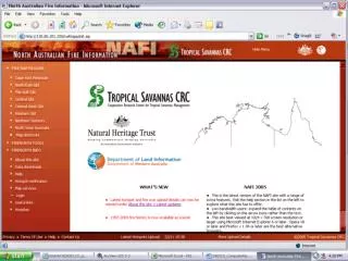
Fire scars are currently being manually processed for the NAFI site from MODIS imagery by the Tropical Savannas CRC. They are uploaded about every 10 days. • WA Department of Land Information is working on automating the identification of fire affected areas from MODIS. • MODIS resolution approximately 250m. • Hotspot data is acquired from WA Department of Land Information and Sentinel. Hotspots are updated approx. every 4 hours.


More Related