Download
1 / 43
430 likes | 581 Vues
Let Water Be the Ligament of Peace in the Himalayan Region. Shaofeng Jia Dr. Prof. Center for Water Resources Research, CAS Institute of Geographic Sciences and Natural Resources Research , CAS. Contents. Water Situation in the Himalayas

E N D
Let WaterBe the Ligament of Peace in the Himalayan Region ShaofengJia Dr. Prof. Centerfor Water Resources Research, CAS Institute of Geographic Sciences and Natural Resources Research , CAS
Contents • Water Situation in the Himalayas • Is Great West Route Diversion naccesary and feasible? • Makewater peace ligament in Himalaya regions
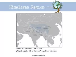
Himalaya Location and landform Pacific Ocean Indian Ocean
Afghanistan China Pakistan Nepal Bhutan India Bangladesh Burma Thailand Countries in Himalaya Region
The rainfall in east Himalaya region InSouth Asia, the west is the driest
How much water? • Especially how much from every country? • We don’t have enough data because of sparse gauge station in high mountain. • We try to apply GIS tool to obtaining water resources and other related information by means of open data.
natural resources • River length • Basin area • Precipitation • Surface runoff Population Cultivated area GDP Indus Ganges Brahmaputra social resources Data concerned
blended river flow • Surface Runoff here is blended river flow that represents a composite of observed and modeled river flow. (See details in Fekete, B. M., C. J. Vorosmarty, W. Grabs. 2002. High-resolution fields of global runoff combining observed river discharge and simulated water balances). • Formountain area, it close to natural runoff. • For plain area, it close to actual runoff.
River length 65.33% GDP 18.49% Cultivated area 2.22% Basin area 64.86% Population 3.88% Natural runoff 14.61% China’s percentages of Brahmaputra Brahmaputra in China
2. Water use trend of China vs GWRDP • Why talk about this? • There are worry that China will divert water from Yaluzangbu! • Great West Route Diversion Project (GWRDP) • ‘Water of Tibet save China’ Li Ling, Guokai • Some others
South to North Water Transfer Project and GWRDP Huanghe GWRDP??? East Rout Huaihe Middle West Changjiang Zhujiang
Is GWRDP Feasible? • For Tibet Autonomous Region, it use very little water:only 1% of runoff withdrawn for human use, mainly for irrigation. • But North China is lacking of water. • Will or not North China divert Yaluzangbu? • For answer this, we should see the water use trend of China!
Inner Mongolia Liaoning Beijing Shanxi Tianjin Hebei Shandong Henan Administrative units of Hai basin
Water scarcity situation of Hai basin • Per capita water resources is less than 300 cubic meters • Water use/Water available ratio higher than 80% The destination of South-North Water Transfer Projects
Water use up and down along with the growth of Per Capita GDP of USA
Industrial water use Turning point Per capita GDP The Kuznets curve law of industrial water use evolution • There is a turning point of water use form increasing to decreasing
Conclusion about water use trend of China • Water use is closing the climax! • Not only for whole China, but also/especially for North China • So China has no need to divert water from Yaluzangbu!
Long term water supply and demand planning of China • Set up total water use limitation for Whole China and every province! • For year 2020, it should be less than 670 billion m3; • For year 2030, it should be less then 710 billion m3! • Compared to recent 598 m3, it’s permitted to increase about 100 billion. And engineering projects has been planned to provide those added supply, while no project of diverting water from Yaluzangbu is considered. • For my personal opinion, it’s not possible for water use of China to reach high to 650 billion!
GWRDP not only not necessary, also not feasible! • Too far: 2000km away • Too high the lifting of water: more than 1000m • Too difficult: high elevation, new technical movement, too complex geological condition • Too dangerous: too frequent geological disaster, such as land sliding, earthquake • Too expensive! The Chinese government has never support and planned it!
Romanticism of engineering Bo sea to Xinjiang Diversion Project: use salt water to harness desert, and let increased vapor to rain and change the desert to oases!
Hydropower station will come! • Not mega-dam! • Only Small reservoir, canals and pipeline • It’s sure there will be some disturbing to ecosystem, but hydropower is greener compared to coal and sustainable. The key point is to look for the balance point between hydro-energy development and ecological protection.
3. Make Water Peace linkage • Will really water substitute for oil as the reason of war? • Will be a water war between India and China?
Long history of exchange • From ancient time, China had very strong linkage with South-East Asia and South Asia! • Buddha • Silk Road • Sea Silk Road • Ancient Tea and Horse RoadShannxi,Sichuan,Yunnan, TibettoIndia
Follow the example of EU! • See each other as friend, not enemy. Attitude may auto-prove! • Seek for the truth! Take care of data and the fact; avoiding misunderstanding • Maintain exchange! • Show good will for cooperation! • China has no intention, no will to use water as weapon to India! Even China want to do so, it’s not feasible! Pakistan and Bangladesh also located in the lower reach, if China flood India, can these two friend countries be saved?
Whatcan we do by ourself? • Personal and civil exchange • Knowledge sharing • Professional explanation and propaganda to media • Cooperative research • Suggestions to the government to promote official cooperation
Thank You ! ShaofengJia Dr. Prof. Vice Director, Center for Water Resources Research, CAS Chair, Department of Water&Land, Institute of Geographical Sciences and Natural Resource Research, CAS jiasf@igsnrr.ac.cn, Shaofengj@hotmail.com