
Uploaded by
ervin
26 SLIDES
429 VUES
260LIKES
Mississippi LiDAR Update Process:
DESCRIPTION
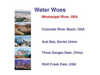
Mississippi LiDAR Update Process:. ‘Dilemma in the Delta’. Jim Steil – Director, MARIS Mississippi Institutions of Higher Learning. Delta = Mississippi Alluvial Plain. Home of the Blues Flat! 4”/Mile average dip Extensive agriculture and land forming Improved drainage Laser leveling
Download
1 / 26
Télécharger la présentation 
Mississippi LiDAR Update Process:
An Image/Link below is provided (as is) to download presentation
Download Policy: Content on the Website is provided to you AS IS for your information and personal use and may not be sold / licensed / shared on other websites without getting consent from its author.
Content is provided to you AS IS for your information and personal use only.
Download presentation by click this link.
While downloading, if for some reason you are not able to download a presentation, the publisher may have deleted the file from their server.
During download, if you can't get a presentation, the file might be deleted by the publisher.
E N D
Presentation Transcript
Mississippi LiDAR Update Process: ‘Dilemma in the Delta’ Jim Steil – Director, MARIS Mississippi Institutions of Higher Learning
Delta = Mississippi Alluvial Plain • Home of the Blues • Flat! 4”/Mile average dip • Extensive agriculture and land forming • Improved drainage • Laser leveling • Catfish farming
Thank You jsteil@mississippi.edu 601.432.6354


More Related