Download
1 / 18
180 likes | 394 Vues
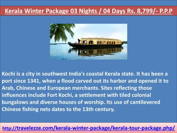
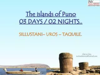
The islands of Puno 03 DAYS / 02 NIGHTS. SILLUSTANI– UROS – TAQUILE. Chat on line: invtravelservice@hotmail.com. Program Includes. Transfer airport/hotel/airport in Puno 02 nights of accommodation with breakfast Tour Sillustani Archeological Complex

E N D
The islands of Puno03 DAYS / 02 NIGHTS.. SILLUSTANI– UROS – TAQUILE. Chat on line:invtravelservice@hotmail.com
Program Includes • Transfer airport/hotel/airport in Puno • 02 nights of accommodation with breakfast • Tour Sillustani Archeological Complex • Tour to the floating islands Uros & island Taquile. • Tourist guide (english – spanish). • Ticket Attraction. • Personal Assistance.
Program not include • Program doesnt includes round trip flights tikets.(lima-puno-lima) Consult our prices • Not including insurance to the traveller - it consults our tariffs • Services non mentioned
Program Rates • Thinking on you, we have created rates according to the type of lodging that you would like to stay. • That´s way, you can choose from 2 stars hotel to 4 stars hotel • Those Rates are for foreigners • Prices are in american dollar (US$) CASH ONLY. Ask about Credit card rates. • If you are Peruvain consult us our especial rates • Those rates can change without warning.
ARCHEOLOGICAL COMPLEX OF SILLUSTANI. • 34 km /21 miles north of Puno (35 minutes by car)This complex stands on the shore of Lake Umayo. It is famous for its chullpas, large circular fortified burial towers for the main leaders of the early villages of the Collao plateau. Some are 12 meters high (39 feet), and remarkable for their shape, thinner at the base and wider at the top. Close to the archeological complex is the site museum where different pieces from the Colla, Tiahuanuaco, and Inca cultures are preserved. • These cultures had a peculiar custom of burial for their noble class: caciques and priests these were buried in funeral towers called Chullpas that mean “Tombs”. • According to the historical sources, the corpse of the patriarch was previously mummify and placed On guard fetal and also their women but beloveds, the preferred servitude were sacrificed and animals, burying them with their consisting of properties gold objects and silver, utensils of ceramics and foods because they considered that after died they will have another life.
Floating Islands of the Uros • 5 km / 3 miles west of the Puno harbor (20 minutes by boat)The Uros Islands (3810 masl / 12.497 fasl) number around 20 and are located in the Bay of Puno. • Three to ten Uro-Aymaras families live on each one. • They roof their houses with totora reed carpets, although some families have replaced their traditional roofs by metal ones. The largest Islands are Tupiri, Santa María, Tribuna, Toranipata, Chumi, Paraiso, Kapi, Titino, Tinajero, and Negrone.The Uros call themselves Kotsuña, “the lake people”, and their origins go back to eras before the Incas. They hunt wild birds and maintain traditional fishing methods, especially those used for the carachi and the silverfish. • The men are skillful handlers of the totora reed boats, and the women are expert knitters. • The characteristic cold and dry weather of the region is tempered in this area thanks to the constantly evaporating water of the large lake.
Lake Titicaca • 10 blocks from the Main Square • This lake is very important in Andean mythology since, according to legend, Manco Capac and Mama Ocllo, children of the sun god and founders of the Inca Empire, emerged from its waters. • Peru and Bolivia share sovereignty over this navigable lake, the highest in the world (3810 masl / 12.497 fasl). It covers an area of 8559 km2 (3305 miles2), a maximum depth of 283 meters (928 feet), and the average water temperature varies from October to May between 9ºC (48ºF) and 11ºC (52ºF) and from June to September between -7ºC (19ºF) and -10ºC (14ºF). Moreover, the lake tempers the area since without its presence, there would not be life at that altitude. • On the Peruvian side of Lake Titicaca, there are several islands; the natural islands include Amantani, Taquile, Soto, and Anapia, and the artificial islands are the ones that the Uros people have built, each one offering different attractions. Along the shores of the lake, totora reeds grow where different birds and fish like the carachis, ispis, bogas, umantos, suches (an endanger specie), silverfish, and trout call home. All these species are native of the area and are prized for their high nutritional value.
Taquile Island • 35 km / 22 miles east of the Puno port (3 hours by boat)Its approximate size is of 6 km2 (2 miles2) and the altitude between the port and the town varies slightly from 3810 to 3950 masl (12.497 to 12.956 fasl). The maximum temperature there is 23ºC (66ºF), and the minimum is 7ºC (37ºF). • Pre-Inca vestiges are found in the highest part of the island. • During the Colonial period and up to the first years of the twentieth century, it was used as a political prison, until the island became property of the Taquile people in 1970. • The town of the same name, Taquile, is characterized by its friendly inhabitants, who maintain their customs and traditional clothing. • They distinguish themselves by their detailed, fine, and colorful textiles with symmetrical decorations and symbols that reflect their way of life, customs, and Andean beliefs.
Rates of the program Rate can change without warning, any time Rate by person Chat on line:invtravelservice@hotmail.com
Map of Perú Puno Location
Knowing about Puno • ALTITUDE Capital : Puno (3827 masl / 12.553 fasl)Lowest point : 820 masl / 2690 fasl (Lanlacuni Bajo)Highest point : 4725 masl / 15.498 fasl (San Antonio de Esquilache)CLIMATE The city of Puno is located on the shores of Lake Titicaca, and its climate is cold and semi-dry. The rainy season starts in October and ends in April. The annual average maximum temperature is 14ºC (58ºF) and the minimum is 3ºC (37ºF). • ACCESS ROUTES By land: • Lima – Arequipa – Juliaca – Puno: 1324 km / 823 miles (18 hours by car) • By air: Regular flights • to Juliaca from Lima (1 hour and 45 minutes, with a stop in Arequipa) • and from Arequipa (25 minutes). • By train: • Cusco – Puno: 384 km / 239 miles (10 hours)