From Sensor Web to Sensor Grid
From Sensor Web to Sensor Grid. Yaohang Li Department of Computer Science North Carolina A&T State University. Agenda. Enabling Sensor Web Sensor Markup Language From Sensor Web to Sensor Grid Research at NCAT. Sensors on the Web. Sensor Web

From Sensor Web to Sensor Grid
E N D
Presentation Transcript
From Sensor Web to Sensor Grid Yaohang Li Department of Computer Science North Carolina A&T State University
Agenda • Enabling Sensor Web • Sensor Markup Language • From Sensor Web to Sensor Grid • Research at NCAT
Sensors on the Web • Sensor Web • Comprise diverse, location-aware environmental sensing devices • Sensors • All connected to the web • All reporting position • All reporting measure • All readable remotely • Most are accessible from the web in real time • Some controllable remotely
Sensor Web at NCAT http://noaa.comp.ncat.edu/AggieWeather/index.html
develop a wireless sensor web which will harvest high volumes of geospatial environmental data from on and around the Juneau Icefield in Southeast Alaska SeaMonster http://seamonster.jun.alaska.edu/browser/
Functions of Sensor Web • Sensor Discovery • Location • Observable • Quality • Programmable • etc. • Obtain Sensor Information • Sensor Data Format • Programming Interface • Programming Sensors • According to Needs • Alerts and Notification • Notify a user when a particular phenomenon happened
Open Geospatial Consortium • Open Geospatial Consortium • An international, non-profit consensus standards organization • Tasks: • Standardize Sensor Web Services • Sensor Web Enablement • OGC Sensor Web Service Standards (APIs) • Sensor Registration Service • Discovery of sensors and sensor data • Sensor Observation Service • Access sensor information (SensorML) and sensor observations (O&M) • Sensor Planning Service • Task sensors or sensor systems • Web Alert Service • Asynchronous notification of sensor events (tasks, observation of phenomena)
SensorML • SensorML • An XML schema for defining the geometric, dynamic, and observational characteristics of a sensor • Characteristics of SensorML • Functional Model of Sensors • Not Detailed Hardware Description • Hardware Independent • Independent of OS (TinyOS, JVM, etc.) • Independent of • Handles Stationary and Dynamic Sensors • Handles in-situ and Remote Sensors
Information Provided by SensorML • General sensor information in support of data discovery • Geolocation of the measure data • Sensor observations • Physical properties measured • radiometry • temperature • concentration • etc. • Response characteristics • temporal response • Sensor performance/quality characteristics • Accuracy and Precision • Threshold • Assumptions regarding the sensors
From Sensor Web to Sensor Grid • Beyond Sensor Web • Sensor Web focuses on sensor data acquisition • Many Sensor Applications Want More
Information Fusion Problem • How can we retrieve the valuable information from the large amount of distributed sensor data? • Sensor Fusion • Distributed Sensor Data Mining
Sensor Trustworthiness Problem • How can we trust the sensor data from the sensor web? • Sensor Correlation • Sensor data verification
Sensor Service Orchestration Problem • How can we coordinate multiple, distributed sensor services? • Temporal-Spatial
Sensor Assimilation Problem • How can we feed distributed, heterogeneous sensor data to computational models to achieve real time processing/forecasting?
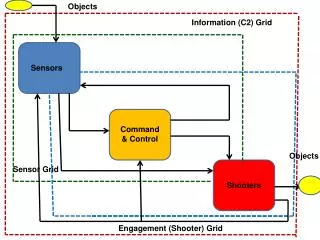
Sensor Grid: Integrating Sensor Networks and Grid Computing • Integrating Sensor Networks and Grid Computing • Give “eyes” and “ears” to a computational grid • Process, model, correlate, and mine real-time, distributed information about phenomena in the physical world • Permit on-the-fly modeling, decision and action • Applications • Environment monitoring • Prediction and early warning of natural disasters
Sensor Grid Figure from Chen-Khong Tham and Rajkumar Buyya
Sensor Grid: Physical World IT World Sensor Data Archive RFID Tag Sensor Hardware & Physics Information Technology Chip Antenna Edge Server Applications
Sensor Grid vs. Sensor Network • Service-Oriented Architecture • Distributed Information Fusion • Nodes in a sensor network are independently sensoring the environment • Redundant Information • Some reading may be inaccurate • Information Fusion • Compute the most probable sensor reading • Distributed Autonomous Decision Making • Can be achieved through an adaptive learing process
EVENT SOURCES Challenge of the Sensor Grid • Many types of event sources and sensors • RFID (handheld, portal, truck mount, etc.), barcode, location, moisture, temperature, … • Many sensor vendors • Alien, Intermec, Matrics, ThingMagic, SAMsys, Zebra • Many different frequencies, protocols, interfaces • LF, HF, VHF, UHF, Microwave • Periodic, Aperiodic • Ethernet, PCMCIA, RS-232 • Many devices in different locations to manage • Device health, device upgrade • Distributed management • Information Capture • Data format not consistent • Data is granular and redundant • Information based on observations from multiple sensor sources
Ongoing NOAA Projects @ NCAT – Earth Information System Framework • New technologies emerging: • Service-oriented architecture, OpenDAP, HDF5, Google Earth, GIS, GEOSS • Framework Approach • Applications can “plug-in” and extend functionality • Can support a broad set of applications with relatively concise software
Interactive Analysis Interactive Visualization Forecast/ Prediction Interactive Visualization Visualization Analysis Data Access Visualization Data Access Earth Information System Predictions, Improved Models, Improved Policies Observations, Models, Policies Uses Framework for • Access • Viewing • Manipulation
Earth System Science “By taking the ‘whole systems’ approach, we are more likely to find sustainable solutions to environmental problems.”
Earth System Model Cryosphere Model Dynamic ice sheet including fast flow. Simple seaice Terrestrial Carbon Cycle Model Simplified TRIFFID Atmosphere Model Non-transient eddy resolving planetary wave Ocean Model 3-D, non-eddy-resolving, frictional geostrophic Terrestrial Hydrology Model Simplified MOSES scheme Ocean Carbon and Nutrient Cycle Model Including sediments
Research @ NCAT • Workflow for a Sensor Grid • Sensor Orchestration • GridNexus • Ensemble-based Kalman Filter for Sensor Data Fusion • From Weather Nowcast to Weather Forecast • Acknowledgement • NOAA-ISET Center