Download
1 / 17
170 likes | 356 Vues
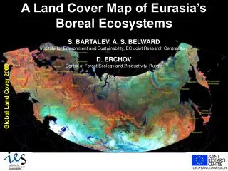
Land Cover Mapping of Iceland and Southern Greenland Global Land Cover 2000. S. Bartalev (JRC EC), V. Egorov (IKI RAN) and E. Bartholomé (JRC EC). Features of regions’ environment and land cover. Duration of vegetation season is extremely short and does not exceed three months

E N D
Land Cover Mapping of Iceland and Southern Greenland Global Land Cover 2000 S. Bartalev (JRC EC), V. Egorov (IKI RAN) and E.Bartholomé (JRC EC)
Features of regions’ environment and land cover • Duration of vegetation season is extremely short and does not exceed three months • Vegetation is mainly presented by tundra type plants adapted to severe climate • Land cover is highly degraded as result of intensive human impact • Volcanic activity results in extensive lava fields and specific atmospheric conditions • Glaciers and permanent snow are significant components of the land cover
Link to Circumpolar Arctic Vegetation Map • Map legend and classes definitions are adopted • Greenland land cover map is involved as reference data • Iceland land cover is not completed in the CAVM
Scale 1: 500.000 Iceland Vegetation Map • Iceland Vegetation Map was used as a reference data • Correspondence of the map legend classes to the CAVM definitions were taken into account
SPOT 4 -VEGETATION data • Both standard data products S1 and S10, including spectral channels and NDVI, for the year 2000 were investigated • Initial data set covers whole year, but because of low Sun elevation the data products contain nonzero values for the period from March until October only • Angular dependence of reflectance properties were not taken into account
Methodological approach • Detection of pixels contaminated by clouds, non-permanent snow/ice and defective SWIR detectors • Synthesis of spectral channels' mosaics for certain time intervals with use of non- contaminated data only • Land cover types classification (hybrid supervised and unsupervised approach) using mosaics of spectral channels
NDSI Water Snow/Ice Clouds Vegetation Red channel Signatures of the land cover classes and clouds : NDSI and RED-channel bi-dimensional space
Contaminated pixels detection Step 1: Detection of the pixels related to snow Step 2: Detection of the pixels contaminated by clouds Step 3: Detection of the pixels contaminatedbydefective SWIR detectors (two iterations) where - reflectance in the Blue, Red and SWIR channels - the mean of - standard deviation of ,
Estimation of the time window for mosaics' synthesis • Snow cover is present most of the time during the year • Vegetation growing season is nearly ten decades
SWIRNIRRed SWIRNIRRed Summer mosaics of Iceland derived from S1 and S10 products derived from S1 products derived from S10 products Period considered is June-August of 2000
June July August SWIRNIRRed Iceland‘s monthly mosaics derived from S1 products
Greenland monthly mosaics Iceland monthly mosaics Reference Vegetation Map of Iceland Unsupervised classification Supervised classification Greenland labeled classes map Island labeled clusters map Reference clusters’ signatures Land Cover Map Merging into thematic classes Land cover classification • unsupervised classification of Iceland with referencing to Vegetation Map of Iceland • supervised classification of Greenland by using Iceland labeled clusters map reference signatures • merging of Iceland and Greenland labeled clusters into thematic classes
Conclusions • Essential advantage of S1 data product in comparison to S10 data product for land cover mapping over Iceland and Greenland was demonstrated • Hybrid of unsupervised and supervised classification approach for Iceland and Southern Greenland land cover mapping was applied to cover the lack of reference data • Interaction with CAVM project and feedback from users of the product is expected to examine and improve quality of land mapping if necessary