Download
1 / 17
200 likes | 631 Vues
Why is the highest annual mean insolation NOT along the equator?. Atmospheric Circulation. L.O.s: To describe and explain atmospheric circulation. To know the impact of the Coriolis Force on the direction of wind.

E N D
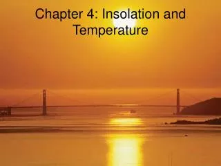
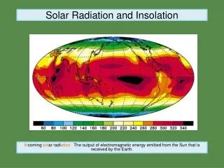
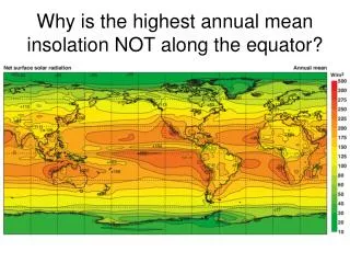
Why is the highest annual mean insolation NOT along the equator?
Atmospheric Circulation L.O.s: • To describe and explain atmospheric circulation. • To know the impact of the Coriolis Force on the direction of wind.
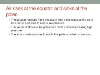
This picture shows the air rising at the equators where it is heated (convection), causing an area of low pressure and then travelling up to the poles losing heat as it goes. At the poles it sinks again (subsidence), being cold, and forms an area of high pressure. It then blows outwards from the poles towards the equator along the surface. In reality the coriolis force and the uneven distribution of land masses and seas also play a part in the air circulation. This means that more than one cell is created.
The Coriolis Force If the Earth did not rotate at all then the air would move at right angles to the isobars, in the direction of the pressure gradient force. But in reality the Earth does rotate and the air moving towards the pole appears to be deflected to the right. This is the result of the coriolis force.
The coriolis force can be explained by using an example of a roundabout. If we consider person a standing in the middle of the roundabout and trying to throw a ball to person B standing at the edge of the roundabout. If A throws the ball straight at B then by the time the ball has reached the edge of the roundabout B has further round. To the people on the roundabout it looks like the ball has curved round to the right.
Tasks: • Add to the diagram where the areas of high and low pressure are. • Add the following labels: • ITCZ • STHP/STJS • PFJS • Add the following labels for the major winds: • Westerlies • SE Trades • NE Trades
The Earth’s rotation means that, in the Northern hemisphere, a wind blowing towards the north appears to move to the right. This explains why the prevailing wind in Britain is a south-westerly, not a southerly.
Exam Question • With the help of a diagram, describe the global distribution of pressure belts and explain why this varies seasonally. 8 marks
Pilots in WW2 flying at heights above 8km found eastward flights much faster then their return westward journeys. Why?
The explanation was found to be a belt of upper-air westerlies, the Rossby Waves which often follow a meandering path. At any given time there is an average of between 4 and 6 of these waves circulating the Earth. It is thought they may be caused by substantial relief such as the Andes, Rockies and Tibetan Plateau although contrasts in surface temperatures are also thought to play their part. Investigation has shown that within these waves velocity is not uniform; within them are narrow bands of extremely fast-moving air known as jet streams. Speeds can exceed 230km/hr (enough to carry a balloon around the Earth within a couple of weeks). The Polar Front Jet Stream (PFJS) forms the division between the Ferrel and Polar Cells. Where in the N.Hemisphere the jet stream moves south, it brings with it cold air which descends in a clockwise direction (giving conditions associated with anticyclones). When the (now warmed) jet stream moves back northwards, it takes with it warm air which rises in an anticlockwise direction (giving conditions associated with a depression). As the usual path of the PFJS over Britain is towards the NE – this accounts for our frequently wet and windy weather. The Sub-Tropical Jet Stream (STJS) forms the boundary between the Hadley and Ferrel Cells. It meanders less than the PFJS, has lower velocities but follows a similar west-east path.
Description of ITCZ/STHP • What it stands for • Location • Where do winds converge/diverge? • Weather associated: • Cloud cover • Air pressure • Precipitation • Stability