Comprehensive Overview of USGS Streamgage Operations and Data Management
Discover the intricacies of the USGS Streamgaging Program, which collects gage height data every 15 minutes and transmits it hourly via GOES. With approximately 9 site measurements per year, these evaluations are crucial for developing stage-discharge relationships and assessing flow estimates. Our traditional and hydroacoustic meter methods adapt to natural channel changes over time. Real-time data available online is provisional, while daily data undergoes an incremental approval process. Subscribe to receive timely notifications about stage, discharge, and quality parameters.

Comprehensive Overview of USGS Streamgage Operations and Data Management
E N D
Presentation Transcript
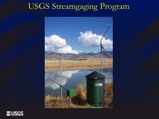
Streamgage Operation • Gage height (not discharge) is collected every 15 minutes. • Transmitted once an hour via GOES
Sites are measured approximately 9 times per year. • Use measurements to determine stage-discharge relationship • Also use measurements to determine “shifts” to the rating • Measurements are also used to aid in estimating flows. Streamgage Operation
Traditional method: AA and pygmy meters HydroAcoustics
Gaging “natural” channels in most cases. • Subject to change through time – scour, fill, vegetation growth • Records are given a rating as reviewed and approved (incrementally), excellent (+/- 5% - about 95% of the daily discharges are within 5% of the true value), good (+/- 10%) fair (> 15%), etc. Streamgage Operation
Data is most accurate just before and after measurements. • Real-time data displayed on the web is provisional and subject to change. Streamgage Operation
Daily data approved incrementally during the year. • Published after end of WY. Streamgage Operation
Threshold notification system. • Subscribe on station page. • Sends email or text. • Hourly or daily. • Works for: • Stage • Discharge • QW parameters WaterAlert
Began in late 1800’s (1889 – Weber R. at Gateway) • 153 Active streamgages • 618 Historic streamgages Utah Data Network replace with updated pic.
Utah Department of Natural Resources • Division of Water Rights • Division of Water Resources • Utah DEQ • Central Utah Water Conservancy District • Bear River Commission • NSIP • U.S. Bureau of Reclamation • BLM • 13 Local entities Cooperators