Download
1 / 9
90 likes | 285 Vues
Summary of Proposal:. Re-Segmentation: multiple segments in the Yampa River Basin ALU classifications and antidegradation designation: Segments 13b ( Foidel , Fish, and Middle Creek) and 13g (Tributaries to Fish Creek)

E N D
Summary of Proposal: • Re-Segmentation: multiple segments in the Yampa River Basin • ALU classifications and antidegradation designation:Segments 13b (Foidel, Fish, and Middle Creek) and 13g (Tributaries to Fish Creek) • Fe ambient-based standards:Segment 13b (Middle Creek and Foidel Creek) • Fe temporary modifications:Segments 13d (upper Dry Creek) and 13i (upper Grassy Creek) • Se ambient-based standards:Segments 13h (lower Dry Creek) and 13j (lower Grassy Creek) • Se temporary modifications:Segments 13b, 13d, 13e, and 13i
Remaining Issues: • Ambient-based Se standards: • Segments 13h and 13j • Foidel Creek Fe standard: • Segment 13b • ALU classification and antidegradationdesignation: • Segment 13g • Duration of Fe temporary modifications • Segments 13d and 13i
Ambient-based Se standards: • Lower Dry Creek (Segment 13h) & Lower Grassy Creek (Segment 13j): • PPHS Exhibit 3, Sections 6.1.2 and 6.1.4, document Se concentrations in upper Dry and upper Grassy Creeks • upstream inputs insignificant, TVS met • Both drainages receive naturally elevated Se from unmined drainages • Temple Gulch (13h) and ScotchmansGulch(13j) • Land use analysis completed, inputs from surrounding irrigation minimal • 700 acres of irrigated land cover the lower Dry Creek basin (Attachment A of Rebuttal) • Seasonal standards proposed to address fluctuations in Se concentrations during spring snowmelt
Ambient-based Fe standard for Foidel Creek: Seasonal standards not appropriate: • All available data has been utilized: 2006 – 2013 • Data has been collected at Site 14 when available • Site 14 (above mine input) dilution from mine at Site 8 Site 900 return to ambient • Ambient conditions are reflected in the data year-round
Segment 13g: ALU and UP designations • Reg. 31.13(1)(c)(iii) definition of class 2 waters: “These are waters that are not capable of sustaining a wide variety of cold or warm water biota, including sensitive species, due to physical habitat, water flows or levels, or uncorrectable water quality conditions that result in substantial impairment of the abundance and diversity of species.” • Reg. 31.8(2)(b)(1)(A): Aquatic life warm class 2 waters default to UP unlessthere are WQ data showing WQ is better than TVS for 10 of the 12 listed pollutants. • Reg. 31.8(2)(b)(1)(C): effluent-dominated waters will be UP (disapproved by EPA) • Reg. 31.5(18) definition: “a stream that would be intermittent or perennial without the presence of wastewater effluent whose flow for the majority of the time is primarily attributable to the discharge of treated water (i.e., greater than 50 percent of the flow consists of treated wastewater for at least 183 days annually, for eight out of the last ten years).” • Consistency with prior Commission decisions that presence of some fish does not equate to aquatic life class 1 classification: • Dry Creek, Sage Creek, and Grassy Creek assigned aquatic life class 2 classification, 2003. • Segments with aquatic life class 2 classification and fish ingestion qualifier (North Platte 7a & 7b, White River 17)
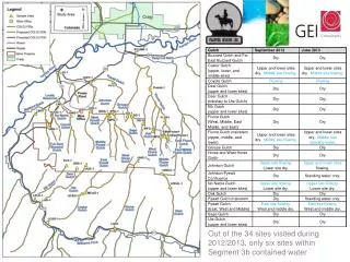
Segment 13g: Aquatic life • Cow Camp and Bond Creeks: • Limited fish populations • Only in spring and only in lower reaches • Limited benthic invertebrate populations • Mostly in spring (uppermost reaches have flows entire year) • MMI scores range from 5-41 • Based on limited habitat • Effluent dependent or dominated reaches • Streams only flow seasonally (PPHS Exhibits 2 and 3, RPHS Exhibit 12 and Rebuttal)
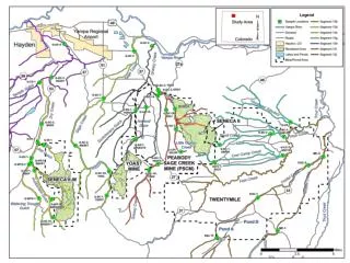
Segment 13g: Flow Summary • See Exhibit 16 • Outfalls 004 and 008 • Located in headwaters of Cow Camp and Bond Creeks • Snowmelt flow peak during April / May (~1 cfs) and return to baseflow by the end of July (~0.1 cfs). • During snowmelt, Outfalls make up majority of flow (>50%) in lower reaches • Outfall baseflow remains relatively constant the remainder of the year (August – March). • During baseflow, discharge is quickly absorbed into underlying alluvium, does not reach to lower watershed. • Lower reaches • Flow during the snowmelt season (April – May) • Quickly return to dry conditions, typically by the end of June • Flow magnitudes during snowmelt comparable to flow at upstream Outfalls • Remainder of the year (July through April), these streams remain dry in the lower alluvial valley, indicative of a low water table (losing stream).
Iron temporary modification duration • Peabody will commit to Commission review in December 2014 • continue its study of the pre-filtration method • meet with the agencies • present a revised plan to the Commission • Setting the end date at June 30, 2015 creates unnecessary wasted effort • Discharge permits administratively extended – Peabody requested modification and issuance • Issuance before end of this year would require nearly immediate modification • December 31, 2016 will be a more appropriate end date because it will allow sufficient time to implement the approved plan and subsequent permit modifications in 2016