Download
1 / 30
300 likes | 402 Vues
This resource covers key concepts of moisture in the atmosphere, including evaporation, transpiration, and energy inputs related to these processes. It highlights air movement types, including breezes and planetary winds, examines pressure gradients, and explores the formation and classification of clouds. The assignment sections prompt critical thinking on fundamental concepts like why condensation is a heating process while evaporation cools. It references relevant textbook pages and homework tasks, making it an invaluable guide for students studying atmospheric sciences.

E N D
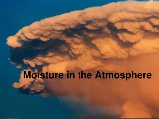
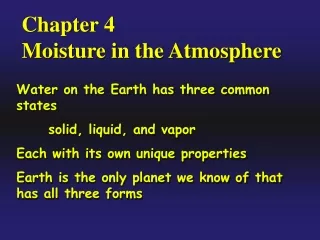
Moisture in the Atmosphere and the Results of Energy Inputs Created By: Mr. Kreeger
Homework and Page References • Review Book- Page 574, 579-584 • Textbook-Pages 485-493 • HW#1-1-3 on page 488 of textbook • HW#2-1-4 on page 493 • HW #3-Explain why condensation is a heating process and evaporation is a cooling process, how do these processes affect storm formation
Table of Contents • Moisture and Energy Input • Air movement • Breezes and currents • Winds • Pressure Gradients • Local Breezes • Planetary Convection Cells • Planetary Winds • Jet Streams • Clouds • Formation/Rising and Subsiding air • Why they form • How are they classified • Precipitation
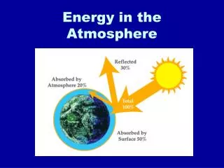
1. Moisture and Energy Input • Moisture in atm depends on • Evaporation-(LG) • Transpiration- Water released by plants • Evapotranspiration- All water vapor released, large amounts of energy (540cal/gm)
2. Air Movement a) Breezes and Currents- A breeze is a small local movement of air while a current is a vertical movement of air (T-Storms)
2b. Winds • A wind is a large horizontal movement of air near the Earth’s surface (named for direction from which it comes), Ex. SW wind means it came from SW and is moving NE. • Pressure gradient-The rate of change in pressure between 2 locations (ESRT), closer the isobars, stronger gradient, stronger wind, further, less gradient, less wind.
Activity on Winds • Determine which scenario world have greater winds. • HP=1025mb, LP=990mb, Dist=5km • HP=1030mb, LP=996mb, Dist=7.5km • HP=1022mb, LP=998mb, Dist=10km
2b2. Local Breezes • Day-Land heats faster than water (LP-Land, HP-Water)-Air flows from sea to land. (Sea breeze) • Night-Land cools faster than water (HP-Land, LP-Water)-Air flows from land to sea. (Land breeze)
2b3. Planetary Convection Cells (ESRT Page 14) • Convection Cell- Cyclic movement due to density difference and effects of gravity. • Variations in insolation(Why?) result in unequal heating of earth’s surface and atm. • Air moves verticallypressure belts produced • Rising air (LP)-Zones of convergence (Moist) • Sinking air (HP)-Zones of divergence (Dry)
2b4. Planetary Winds(ESRT Page 14) • If earth did not rotate and was equally heated 1 convection cell would be produced from NP to equator. • BUT>>>>> it is modified by Corilois effect which aid in creating a planetary wind system. • At equator- Wind moves due to trade winds • At mid latitudes- move due to prevailing westerlies • At high latitudes- move due to polar easterlies
2b5. Jet Streams • Winds at high altitudes that control movements of air masses. • Travel at 7-8 miles high( travels at 200 kph, travels faster in winter) • Migrates from 31N in winter to 50 N in summer Why?
3. Clouds • Formation-Condensation, need a surface called cloud condensation nuclei (CCN), can only occur when saturation happens (Dewpoint=Air Temp) and a CCN is present i.e. dust, salt • Condensation is a heating process- fuel for storms (540 cal)
Rising and Subsiding Air High P 1. RISING AIR EXPANDS AND COOLS Lower P High P Higher P Lower P Lower P 2. SUBSIDING AIR IS COMPRESSED AND WARMS Low P Higher P (surface)
3c. How are clouds classified • Divided into groups based on the height in which they form.
High Clouds • > 6000 m • Cold and “dry” - thin • Almost exclusively ice crystals Cirrocumulus halo mackerel sky mares’ tails
Middle Clouds • 2000 – 7000 m • Mostly water droplets, some ice crystals Morning Ac means afternoon thunderstorms in summer No halo, associated with warm fronts, form before storms
Low Clouds • <2000 m • Almost always water droplets (ice and snow in winter) Light-moderate rain For long duration High pressure, Stabile weather Fog that doesn’t reach the ground, drizzle
Clouds with Vertical Development • Cumulonimbus – unstable atmosphere • Rapid convection brings tops to 12 km • Form thunderstorms / lightning Fair weather Thunderstorms
4. Precipitation • When water droplets or ice crystals grow large enough to fall. • Types • Rain • Snow • Sleet • Freezing rain • Hail
Rain • Drops of water that fall from a cloud with a diameter of >0.5mm • Originates from nimbostratus or cumulonimbus clouds • Begins often as snow crystals, but also as raindrops
Snow • Packets of ice crystals • Low temps light fluffly snow or “powder” • Warm temps (-5C) heavy moist snow
Sleet • Sleet = small, translucent particles of ice • Formed as ice, melted, refrozen as ice pellets
Freezing Rain • Subfreezing air near ground is not thick enough to allow raindrops to freeze • Raindrops supercooled
Hail • Hard round pellets • Concentric shells of ice from traveling up and down a convective cloud • Produced in large cumulonimbus clouds, speeds = 160km/hr