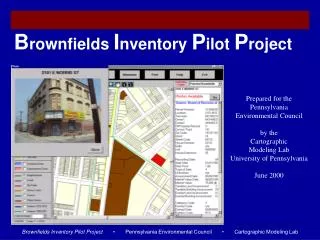
B rownfields I nventory P ilot P roject
B rownfields I nventory P ilot P roject. Prepared for the Pennsylvania Environmental Council by the Cartographic Modeling Lab University of Pennsylvania June 2000. Introduction. Scope of the Project. Three Major Activities Fieldwork Data work Application Development

B rownfields I nventory P ilot P roject
E N D
Presentation Transcript
Brownfields Inventory Pilot Project Prepared for the Pennsylvania Environmental Council by the Cartographic Modeling Lab University of Pennsylvania June 2000
Introduction Scope of the Project • Three Major Activities Fieldwork Data work Application Development • Two Phases Phase I: New Kensington (Eastern North Philadelphia) Phase II: Delaware Waterfront • Many Partners Pennsylvania Environmental Council Pennsylvania Horticultural Society New Kensington CDC Philadelphia City Planning Commission Cartographic Modeling Lab
Functions Application Basics
Functions Log-on to the Brownfields Inventory The Brownfields Inventory Pilot Project is a stand-alone Map Objects application
Functions Selection Layers Parcels: PCPC Potential Brownfields: BRT. Pilot Area Boundaries • Two Pilot Areas: • New Kensington • Delaware Waterfront
Functions Data Layers
Functions Takes user to query screen Allows user to query data records Creates a report of queried records Provides metadata Allows user to print records Provides a help manual Closes the application Takes user to log-on screen Button Bar The button bar takes users to the different interfaces of the application and provides information and help for the application.
Functions Zooms in on area of the map Zooms out on map Zooms to the full extent of Philadelphia Pans across the surface of the map Selects a single record on the map Selects Multiple records on the map Tool Bar The tool bar allows users to interact with the data layers by zooming in and out and by selecting individual or groups of brownfields.
Functions Query Window The querying window allows users to select brownfields based on characteristics of individual properties or on a variety of external spatial criteria such as different wards and districts.
Data Used The Data
Data Used Brownfield Fieldwork - Preparation • EPA Brownfield Definition: • Abandoned, idled, or under-used industrial and commercial facilities where expansion or redevelopment is complicated by real or perceived environmental contamination • Previously identified brownfields were collected from: • EPA’s CERCLIS • Pennsylvania Department of Environmental Protection
Data Used Date___________ Interim Address________________ Photo Numbers_________________ Final Tencode Partially in use? PCPC Parcel Match? Partial YES No Sketch YES No NOTES_______________________________________________________________________________________________________________________________________________________________________________________________________ Brownfield Fieldwork Data Sheet Field Photos Port Richmond Railyard Tacony Warehouse
Data Used Philadelphia City Planning Commission Parcel Coverage • The Philadelphia City Planning Commission provided parcel coverage data for the study areas. Brownfield • Brownfields identified through fieldwork were matched with this parcel coverage and its associated tencodes. 2653001701 • The data -- although imperfect -- is the best available for a large scale study of brownfields.
Data Used Board of Revisions and Taxation (BRT) • The Board of Revision of Taxes is mandated to annually estimate and review the Fair Market Value of all Real Estate in the jurisdiction of Philadelphia. • Key data elements include: • Address • Parcel number • Tencode • Building description • The CML requested and the City of Philadelphia granted use of the BRT data exclusively for the brownfields pilot project application.
Data Used Sanborns • Sanborns are historical fire insurance maps that record a property’s use over time. They capture three time periods: the 1920s, 1950s, and the 1980s. • These maps were used to identify industrial properties.
Data Used Other data • Other data sources came from a variety of different agencies throughout the City of Philadelphia and contain public information supplied in a spatial format. • These layers primarily provide boundaries and names of individual districts and geographies.
Using the Application Demonstration
Next Steps Challenges & Next Steps
Data Used 1. Improve Match Rates and Parcel Data • Tencodes are “unique” identifiers assigned by the City to individual parcels. • Match problems: • In some cases, properties identified in the field did not match the PCPC’s parcel coverage. • In other cases, PCPC’s tencode did not match the BRTs tencode. • These problems are worse in some parts of the City than in others • The CML and PEC would like to work with the City to improve match rates and parcel data. 1 BRT Tencode Match 6 Brownfields > 4 PCPC Tencode Matches >
Next Steps 2. Find a Permanent Home for the Inventory • Because brownfields require the assistance of many groups and organizations, this project must be housed by a single agency if it is to be effective. • Data collection must be controlled • Needs of all interested groups must be addressed • Updates and other maintenance must be performed regularly
Next Steps 3. Expand the Inventory: New Corridors • Candidate Corridors • Schuylkill River • Central North Philadelphia • RR corridors • Others • Interested Organizations • Commerce Department • PEC • DEP • Area CDCs • Railroad interests • Rivers interests • Others
Next Steps 4. Internet Access: Neighborhood Information System • A CML project to integrate parcel data from multiple City agencies. • The NIS is accessible via the internet and data is updated twice a year. • Technical and access issues must be resolved.
Next Steps 5. Update and Expand Fieldwork 425 Moyer St after the building caught fire • Provide funding to CDCs to update photos, site information • Other organizations could also perform updates on a contract basis • Migrate brownfields application into the NIS for semi-annual data updates. 425 Moyer St after the site was cleaned
Next Steps Creating Success Stories Thonet Manufacturing Site, York Before After • Keep community involved • Make brownfield properties available • Attract development During