
Ithaca Station
E N D
Presentation Transcript
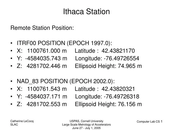
Remote Station Position: ITRF00 POSITION (EPOCH 1997.0): X: 1100761.000 m Latitude : 42.43821170 Y: -4584035.743 m Longitude: -76.49726554 Z: 4281702.446 m Ellipsoid Height: 74.965 m NAD_83 POSITION (EPOCH 2002.0): X: 1100761.543 m Latitude : 42.43820321 Y: -4584037.171 m Longitude: -76.49726318 Z: 4281702.553 m Ellipsoid Height: 76.156 m Ithaca Station USPAS, Cornell University Large Scale Metrology of Accelerators June 27 - July 1, 2005
Geoid Page: http://www.ngs.noaa.gov/GEOID/ Geoid undulation: GEOID03, GEOID99 Deflection of the vertical: DEFLEC99 Datum Conversion: Use NADCON (North American Datum Conversion) to convert latitude and longitude from NAD 27 to NAD 83 or from NAD 83 to NAD 27.http://www.ngs.noaa.gov/TOOLS/Nadcon/Nadcon.html Program VERTCON computes the modeled difference in orthometric height between the North American Vertical Datum of 1988 (NAVD 88) and the National Geodetic Vertical Datum of 1929 (NGVD 29) for a given location specified by latitude and longitude.http://www.ngs.noaa.gov/TOOLS/Vertcon/vertcon.html NGS Sitehttp://www.ngs.noaa.gov/ USPAS, Cornell University Large Scale Metrology of Accelerators June 27 - July 1, 2005