OUR COUNTRY - INDIA
11.83k likes | 35.57k Vues
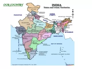
OUR COUNTRY - INDIA. KEY WORDS. peninsula boundaries alluvial tributary delta coastal plain states union territories corals polyps island. 2. INDIA : The Country. Area: 3.28 million sq. Km North-South (Kashmir to Kanyakumari): 3200 km

OUR COUNTRY - INDIA
E N D
Presentation Transcript
KEY WORDS • peninsula • boundaries • alluvial • tributary • delta • coastal plain • states • union territories • corals • polyps • island 2
INDIA : The Country • Area: 3.28 million sq. Km • North-South (Kashmir to Kanyakumari): 3200 km • East-West (Arunachal Pradesh to Kutchch): 2900 km • Population: 1.15 billion (second most populous country) • Landforms: mountains, desert, plains, plateau, coastline and islands. • Diversity in landforms, climate, vegetation, wildlife, language and culture.
Peninsula • It is a piece of land that is surrounded by water on three sides. • Eg. India, Colaba in Mumbai, Florida in USA, Mexico etc. • They are sometimes called as “half islands”.
Locational setting • Northern and eastern hemisphere. • South-North: 8ᴼ4’N to 37ᴼ6’N (latitudes) • West-East: 68ᴼ7’E to 97ᴼ25’E (longitudes) • Tropic of Cancer passes through the centre of India • Longitudinal extent of 29ᴼ causes a wide difference of 2 hrs in local times in Gujarat and Arunachal Pradesh. • Standard Meridian of India: 82ᴼ30’E. • Time on this meridian is Indian Standard Time.
Neighbouring countries of India • Pakistan • China • Nepal • Bhutan • Bangladesh • Myanmar • Afghanistan • Sri Lanka • Maldives
Political and Administrative Divisions • 28 states • 7 union territories • New Delhi is the national capital • Rajasthan is the largest state in terms of area. • Goa is the smallest state in terms of area. • The states are further divided into districts.
PHYSICAL DIVISIONS • The Himalayas: • Marks the northern borders of India • Him+alaya means ‘the abode of snow’ • Divided into 3 parallel ranges: • Northernmost range “Great Himalaya” or “Himadri”, having the world’s highest peaks • “Middle Himalya” or “Himachal” famous for its many hill stations • The southernmost range “Shiwalik” with low peaks which merges into the plains.
PHYSICAL DIVISIONS • The Northern Indian Plains: • Lie to the south of the Himalayas. • Level and flat • Formed by alluvial deposits of the Ganga, Brahmaputra, Indus and its tributaries. • Provide fertile land for cultivation and population.
PHYSICAL DIVISIONS • The Great Indian desert • Western part of India. • Dry, hot and sandy stretch of land. • It has very little vegetation because of lack of moisture and unfavourable weather conditions. • Hence, it supports very little population.
PHYSICAL DIVISIONS • The Peninsular Plateau: • Triangular in shape • Relief is highly uneven • Aravali hills borders it on the north-west side. • The Vindhyas and the Satpuras are the important ranges. • West flowing rivers draining into Arabian Sea are Narmada and Tapi • Western and Eastern Ghats mark the western and eastern sides. • Western Ghats are continuous but the Easter Ghats are broken and uneven. • The plateau is rich in minerals like coal and iron-ore.
PHYSICAL DIVISIONS • The Coastal plains: • Plains found to the west of Western Ghats and East of Eastern Ghats. • Western coastal plains are narrow while the eastern ones are much broader. • There are many east flowing rivers like Mahanadi, Godavari, Krishna and Kaveri which drain into the Bay of Bengal. • They form fertile deltas at their mouths.
PHYSICAL DIVISIONS • The Island Groups: • Two groups of islands are part of the Indian Union. • Lakshadweep Islands are located in the Arabian Sea. They are coral islands located off the coast of Kerala. • The Andaman and Nicobar islands lie to the southeast of the Indian mainland in the Bay of Bengal. • This group of islands were badly affected in the disastrous tsunami of 2004.
GANGA-BRAHMAPUTRA DELTA • It forms the largest delta in the world, known as the Sunderban Delta. • The delta is triangular in shape. • It is an area of land formed at the mouth of the river, where the river enters into the sea.
Terms • Peninsula-a piece of land almost surrounded by water or projecting out into a body of water. • Plains-a large area of flat land with few trees. • Plateau-a flat elevated land; a table land • Tributary-a river or stream flowing into a larger river or lake. • River delta-A river delta is a landform that is formed at the mouth of a river, where the river flows into an ocean, sea, estuary, lake, or reservoir. They are formed from the deposition of the sediment carried by the river as the flow leaves the mouth of the river. • Coastal Plains-a plain adjacent to a coast 16