The Texas Instream Flow Program
The Texas Instream Flow Program. Barney Austin Surface Water Resources Division Texas Water Development Board. May 21, 2004. Senate Bill 2. The Texas Legislature directed tri-agencies (TPWD, TWDB, and TCEQ) to:

The Texas Instream Flow Program
E N D
Presentation Transcript
The TexasInstream Flow Program Barney Austin Surface Water Resources Division Texas Water Development Board May 21, 2004
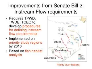
Senate Bill 2 The Texas Legislature directed tri-agencies (TPWD, TWDB, and TCEQ) to: • Establish and continuously maintain an instream flow data collection and evaluation program, and • Develop methodologies to determine flow conditions in Texas rivers and streams necessary to support a sound ecological environment.
Senate Bill 2 Framework for Instream Flow Study Program requires tri-agencies to: • Share oversight of program studies. • Share data, studies, analysis, information and reports. • Establish a Work Plan that prioritizes studies and sets interim deadlines for publication of flow determinations, and • Complete priority studies by December 31, 2010.
Senate Bill 2 Framework for Instream Flow Study also: • Requires TCEQ to consider the results of completed studies in its review of any management plans, water rights, or interbasin transfers.
Joint study accomplishments: • Interagency MOA • (Executed: Oct 17, 2002) • Programmatic Work Plan • (Final: Dec 19, 2002) • NAS contract (July 2003) • Technical Overview • (Draft: August 8, 2003)
Texas Instream Flow Studies
Timeframes for Priority Studies Toledo Bend Sabine R.
Second Tier of Studies Developed to provide future direction in studies in the event priorities change or supplementary resources are made available. These include: • Upper Guadalupe River • Neches River • Red River • Upper Sabine River Colorado R. Two special studies include the Sulphur River (on-going) and the Lower Colorado River (monitoring). Sulphur R.
TCEQ – Water Quality & Specific Numeric Criteria • Tiered Aquatic Life ----- D.O. • Toxic Criteria • Aquatic Life • Human Health • Bacteria ---- Contact Recreation • Chloride, Sulfate, Total Dissolved Solids • pH as absolute minima and maxima • Temperature as absolute maxima
Sound Ecological Environment Conserve Biodiversity • fish, invertebrates, mussels, plants … • riparian diversity Maintain Ecological Integrity • processes & functions that create & maintain habitat & other physicochemical conditions that support survival, growth, & reproduction
Biological approach • Coordinating Agency - Texas Parks & Wildlife • Field surveys to develop sampling strategies and characterize biota and habitat • 3 contracts to be executed for reconnaissance on priority sub-basins. • Habitat-based approach • Geomorphology, hydrology and hydraulics • Two complementary analyses using spatially-explicit habitat models • Microhabitat availability using habitat guilds and/or target species • Habitat heterogeneity (diversity/complexity) using landscape metrics • Develop habitat-discharge functions and time-series • Important to consider: • Both channel and riparian areas…also consider watershed; connectivity • Key habitats; environmental requirements and life history of flow dependent biota • Temporal considerations
Hydrology & Hydraulics TCEQ - Water Availability Model (WAM)
Hydraulic Modeling – Brazos River Detail Area DOQQ photo taken February 4, 1995; ~7,500 cfs Boundary of FE Mesh used for flows below 3350 cfs is shown in green.
Hydraulic Modeling – Brazos River • Finite Element Mesh (approximate element resolution 8m x 10m) • RMA-2 (depth averaged, hydrostatic Reynolds Averaged Navier-Stokes equations) • 1456 cfs shown FE mesh with depth contours 0.0m to 4.0m FE mesh with velocity contours 0.0 to 2.25 mps
Hydraulic Modeling – Brazos River • Photo of “Island” area, November 2, 2001. • Flow is approximately 1500 cfs.
Habitat Modeling– Brazos River • Mesohabitats are delineated for 1456cfs using a grid-based GIS model
INSTREAM FLOW STUDY: Brazos River near Allens Creek Reservoir Velocity Contour Plot
Modeling Issues – Large woody debris South Sulphur near Cooper • Large Woody Debris (LWD) influences both hydraulics and habitat utilization analysis North Sulphur (near confluence) Sulphur US of Patman (near Site 2)
Typical radial bounding regions MEBAA bounding boxes Modeling Issues – Mesh Interpolation Interpolating bathymetric single-beam data to the finite element mesh Exploit the anisotropic shape of the river cross-section for a better interpolation Use flow-directional coordinate system (either linear {TWDB} or curvilinear {CRWR})
Modeling Issues – Mesh Interpolation Improved IDW interpolation using Mesh Elevating and Bathymetry Adjusting Algorithms (MEBAA) Standard IDW interpolation using Surface Water Modeling System
Surveying (High Flow) Modeling (Low Flow) Modeling Issues - Geomorphology • Bathymetry that changes with flow Affects both hydraulic and habitat analysis
Physical Processes • Flushing flows (> once per year) • Restore/enhance riffle habitat • Remove surficial and interstitial fine sediment • Determined through study of sediment and hydraulic model output • Channel maintenance (circa 1.5 per year) • Maintain physical characteristics of the channel • Study of flow-duration curves • Floodplain maintenance (once per 1-10 years) • Build and bring nutrients to the floodplain • Extent and frequency from (existing?) 1-D models or aerial photos • Valley maintenance • Q25-ish
National Academy of Sciences • $300k contract executed in July 2003 • Evaluate science and methodology in key documents • Review and provide advice on scientific and technical matters relevant to the Instream Flow Program • Evaluate findings and recommendations of Tasks 1 and 2 for consistency with the requirements of Texas law for the study of Instream Flows Final Report due Oct 2004 Dr. Lauren Alexander (NAS) testified at the Feb 18th Study Commission meeting
National Academy of Sciences • Have had three open meetings in Texas • Austin, San Antonio, San Marcos • Questions/answers and public testimony • “Panel of experts” for second meeting • Not able/willing to release draft report • Comprehensive guide to be used by any entity conducting instream flow studies in Texas…and beyond?
Instream Flow Study Program Results Will Be: • An essential database for conservation of fish and wildlife resources in Texas. • Used in the State’s water rights permitting process, and • Incorporated into future regional and state water plans.
For more information…. Barney Austin Texas Water Development Board Tel: 463-8856 Email: barney.austin@twdb.state.tx.us http://www.twdb.state.tx.us/InstreamFlows/