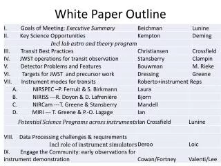
Download

1 / 49
490 likes | 602 Vues
This white paper from the Connecticut Association of Wetland Scientists discusses the status of wetland buffers in Connecticut. It covers topics such as legal authority, different buffer terminology, regulated areas, and municipal regulations. The paper offers findings, recommendations, and conclusions on buffer regulations, sizes, design considerations, and the importance of vegetation in buffers. It emphasizes the need for education, protocol development, maintenance, and enforcement to protect and improve water quality through effective buffer management.

E N D
Land-Tech Consultants, Inc. Environmental Scientists and Engineers Wetland Buffers The White Paper Robert Jontos, PWS, CPESC Connecticut Association of Wetland Scientists 7th Annual Meeting February 25, 2004
Status of Buffers in Connecticut Topics to be covered: • Summary of 2003 Presentation • Introduction • Objectives • Findings • Recommendations CAWS 7th Annual Meeting - Buffers
Status of Buffers in Connecticut Summary of 2003 Presentation: • Legal Authority - Municipal Inland Wetland and Watercourses Agencies can regulate activities outside of their jurisdictional areas provided that: • Buffers are provided for in their regulations • Proposed upland site activitieswill or may affect jurisdictional areas CAWS 7th Annual Meeting - Buffers
“Setback Area” and “Non-disturbance Area” Often used interchangeably with the term buffer, but not interchangeable for the purposes of the white paper Physical dimension Vegetation may not be managed “Upland Review Area” Not a buffer, but a dimensioned distance from a wetland or watercourse “Riparian Area” The land immediately adjacent to a watercourse Lake, pond, or stream Terminology Defined CAWS 7th Annual Meeting - Buffers
Common Names: “Buffer Area” “Vegetative Buffer Strip” – VBS Interchangeable terms Definition: Typically defined as a vegetative upland area (determined by soils, topography and vegetation) directly adjacent to a wetland or watercourse with ecological, hydrologic and physical connections to the wetland or watercourse. Vegetative Buffer - Definition CAWS 7th Annual Meeting - Buffers
Buffer vs Vegetative Buffer “Buffer” • Setback, non-disturbance area, or upland review area; a physical dimension only “Vegetative Buffer” • Functional entity used to treat stormwater runoff, and enhance/protect/preserve water quality. CAWS 7th Annual Meeting - Buffers
Regulated Area or Setback Regulated area or setback watercourse & wetland Regulated Area or Setback is a distance from a wetland or watercourse which is defined by local Land Use Agencies
Riparian Area uplands uplands floodplain floodplain wetland wetland watercourse Riparian Area is defined as the lands immediately adjacent to a watercourse up to the limits of the floodplain
Vegetated Buffer vegetated buffer watercourse & wetland Existing vegetation and turf Vegetated Buffer shown – native planted strip between wetland/watercourse and upland existing vegetation
Summary of 169 Municipal Regulations“Regulated Areas” * 16 COMMUNITIES WITH VARIABLE DISTANCES 19 COMMUNITIES USE RESOURCE SPECIFIC SETBACKS 6 COMMUNITIES INCREASE SETBACK WITH SLOPES > 10-15% 2 COMMUNITIES USE FLOOD BOUNDARIES CAWS 7th Annual Meeting - Buffers
Summary of 169 Municipal Regulations“Regulated Areas” Number of Towns with setback distance CAWS 7th Annual Meeting - Buffers
Summary of 169 Municipal Regulations“Regulated Areas” • Not all communities have setbacks cited in their regulations • Setback distances cover a broad range of distances, variables (slope angle, land use) • Some communities use resource specific setbacks (river, watershed, floodplain) • None cite a methodology for determining “buffer” width CAWS 7th Annual Meeting - Buffers
2003 Buffer Conclusions 1)Buffer regulations don’t consider individual buffer functions nor the characteristics or condition of the buffer. 2) Buffer size is either “fixed” or “variable” Fixed width – easily enforced, existing and proposed conditions not considered Variable width - Considers site specific conditions, trained staff, variability CAWS 7th Annual Meeting - Buffers
2003 Buffer Conclusions Combined Approach: a) Education – designers, reviewers and “the Public” b) Accepted and defensible protocol for design & application c) Combine with LID & BMPs d) Maintenance/Management e) Enforcement CAWS 7th Annual Meeting - Buffers
2004 Vegetative Buffer White Paper -Drafted by CAWS members for use by designers and regulatory agencies & commissions - Academically and legally critiqued - Purpose: education, design parameters, review criteria, management methods CAWS 7th Annual Meeting - Buffers
Vegetative Buffer White Paper Motivation: - Science based methodology for design, regulation and effective management of vegetative buffers - Version 1.0 - Working document - Initial focus: Protecting and improving water quality CAWS 7th Annual Meeting - Buffers
Vegetative Buffer Functions • Sediment removal (filtration) • Nutrient removal (plant uptake & soil adsorption) • Stormwater runoff (filtration & infiltration) • Water temperature moderation • Habitat and wildlife diversity CAWS 7th Annual Meeting - Buffers
Buffer Sizing and Design General Considerations -“one size does not fit all” • Objectives must be defined • Watershed position • Existing plant composition and density • Soils and Slope conditions (above & within buffer area) CAWS 7th Annual Meeting - Buffers
Buffer Sizing and Design Objectives: • Runoff filtration & infiltration • Streambank stabilization • Downstream flood attenuation • Wildlife habitat and corridors CAWS 7th Annual Meeting - Buffers
Buffer Sizing and Design Watershed position • Position does impact effectiveness • Buffering low order streams (1st-3rd), greater impact on water quality than wider buffers on large order streams – sediment source control CAWS 7th Annual Meeting - Buffers
Buffer Sizing and Design Existing plant composition and density • Inventory existing species & density • Use “undisturbed” riparian community as guide for enhancement/management • Ground cover critical element • Microtopgraphy within buffer area may permit channeling of surface flow CAWS 7th Annual Meeting - Buffers
Buffer Sizing and Design Soils and Slope Placement of well developed vegetative buffer strip (VBS) between erosive soils or soils exposed for extend periods reduces the velocity of runoff, thus reducing scour potential & sediment movement, and promotes sheet flow/infiltration CAWS 7th Annual Meeting - Buffers
Buffer Size: Recommend Width for Water Quality Approaches: • Regression analysis (Dillaha, et al., 1986) quantify buffer performance based on sediment, nitrogen and phosphorus removal - Based on limited database, low flow rates (1.8L/s-m), narrow buffers <11.2 meters - Site specific, slope not considered - Requires subshed runoff to be calculated using standard engineering analysis - Trial and error, checking tool CAWS 7th Annual Meeting - Buffers
Buffer Size: Recommend Width for Water Quality • Welsch (1991) “Three Zone Method” • Sweeney (1992) modified “Three Zone” • fixed width Three Zone method for riparian forest restoration • Westchester Environmental Management Council Method • considers slope CAWS 7th Annual Meeting - Buffers
Welsch (1991) “Three Zone Method” (after Welsch, 1991) CAWS 7th Annual Meeting - Buffers
Sweeney (1992) Modified Three Zone Method (after Sweeney, 1992) CAWS 7th Annual Meeting - Buffers
Westchester County Method (1981) • Minimum starting buffer width of 7.6 m (25 ft) • Increase buffer width by 0.9 meters (3.0 ft) for each percent (%) increase in slope • Reduce buffer width by 0.1 meters (1.0 ft) for each 0.9 meter (3 ft) of adjacent brush or woodland growth in good hydrologic condition • Slopes >15% and/or slope runs > 200 ft and/or if filter is in dense shade or subject to heavy traffic, then temporary E&S controls and level spreader required CAWS 7th Annual Meeting - Buffers
Selecting Buffer Widths: Additional Methods • Connecticut Guidelines for Sediment and Erosion Control 2002 (50 ft to >1600 ft, 10% max. slope ) • Finley (1987) 15m (49 ft) starting width, increase 6m (19.7 ft) for each 5% increase in slope to a maximum slope of 25% and 150 feet width CAWS 7th Annual Meeting - Buffers
Drainage Area Riparian Buffer Zone Effective Buffer Area Wetland Watercourse flow flow Gross Area of Buffer Effective Buffer Area Modified after Dossky et al. 2002 CAWS 7th Annual Meeting - Buffers
Physical Environment Soil Type – Drainage class/hydrologic group, erodibility Index Topography – Greater the slope, faster the runoff, increase in soil erosion and sediment transport potential “Area Ratio” - size of the drainage area contributing flow to the buffer, smaller the ratio, better the treatment CAWS 7th Annual Meeting - Buffers
Drainage area V.B.S watercourse Area Ratio CAWS 7th Annual Meeting - Buffers
Buffer Size: Recommend Width for Water Quality • Observations from the literature reviewed: • Width of VBS range between 2 - 500 meters/ 6.5 – 1,640 feet • Majority fall within 4.6 – 15 meters/15 – 49 feet. • Slope of buffer >10%, increase in width • Area ratio range 15:1 to 5:1 or less • Plant species composition affects efficiency CAWS 7th Annual Meeting - Buffers
Buffer Size: Recommend Width for Water Quality Plant Composition: • Grass – effective in removing coarse sediment and absorbing nutrients • Shrubs – maintain soil infiltration capacity • Combined grass and shrub filter more effective than grass alone • Ideal VBS is transition - grass, shrubs and trees CAWS 7th Annual Meeting - Buffers
Plant Type vs. Removal Efficiency Mod. after Fisher & Fischenich, 2000 CAWS 7th Annual Meeting - Buffers
Plant Species, Numbers & Sizing • Diversity of plant species within the buffer insure better success in response to variable environmental conditions (temp., herbivory water levels) • A mixture of native herbaceous, shrub and tree species appropriate to the environment • Habitat Diversity – variable amounts and types of plants, over microtopography CAWS 7th Annual Meeting - Buffers
Plant Species, Numbers & Sizing Tree Diversity • Fisher and Fischenich, 2000) CAWS 7th Annual Meeting - Buffers
Plant Species, Numbers & Sizing Tree Planting Densities: • 400/acre, 10” to 48” tall • 200/acre, 15 ft tall • 3 - 5 ft tall saplings spaced 15 feet on center may reduce negative impacts of browse, better survival • Shrub planting – 2-3 feet tall, 5-8 feet on center CAWS 7th Annual Meeting - Buffers
Plant Survival Management Measures: • Use of plastic tree shelters with mulch and herbicide, best seedling survival • Grasses harvested to encourage dense growth, remove nutrients • Control invasives – mechanical, hand, mulch, herbicide or prescribed burning • Remove sediment, fill rills and re-create microtopography and re-seed/replant. CAWS 7th Annual Meeting - Buffers
Observations & Recommendations • Vegetative buffer strips (VBS) are an effective BMP in urban and agricultural settings. One-size does not fit all, bigger may not be better due to channelized flow • Vegetation provides E&S control, non-point nutrient and pollutant removal, promotes infiltration CAWS 7th Annual Meeting - Buffers
Observations & Recommendations • Buffer Effectiveness dependent upon:a) Species and density of vegetation within the bufferb) Soil type above and within the bufferc) Slope of the buffer and contributing watershed area – microtopgraphyd) Length of the buffer (width of flow path) and Area ratioe) Proposed land use above the buffer CAWS 7th Annual Meeting - Buffers
Observations & Recommendations • VBS can be used as stand alone BMP, but are more effective when used in combination with other BMPs/LIDs • Long continuous buffer strip rather than segmented, can be variable in width depending on site conditions and design goals CAWS 7th Annual Meeting - Buffers
Observations & Recommendations • Combination of grass, shrub & trees in sequence more effective in removing sediment, adsorbing nutrients, other NPS pollutants and maintaining soil infiltration • Native species should be used to enhance or create VBS in combination with long-term management plan. CAWS 7th Annual Meeting - Buffers
Observations & Recommendations • Infiltration is key to reducing sediment and adsorbing pollutants • Smaller area ratios (5:1) are more effective in sustaining filtering efficiency of VBS • Buffer widths – 5m (16ft) to 15m (49ft) effective in reducing sediment loads and protecting water quality CAWS 7th Annual Meeting - Buffers
Observations & Recommendations • In Urban/agricultural areas with slopes of <10% with limited area, 5m wide grass VBS are effective in removing significant amounts of NPS pollutants • In watersheds under development with slopes 10% or less and typical soil transitions, a minimum buffer of 10m (33 ft) can be effective. CAWS 7th Annual Meeting - Buffers
Observations & Recommendations • With slope conditions >10% and: • wetlands & watercourses with moderate to high functional values or critical habitats (bogs, fens, wetland complexes) • or where water quality is a critical issues (public water supply watershed or impaired watercourse) A minimum buffer of 10m + (50 ft or greater) should be considered with BMPs CAWS 7th Annual Meeting - Buffers
Observations & Recommendations • Functional goals of the Vegetative Buffer Strip must be clearly defined and a management plan prepared to establish and maintain those functional goals both during and after development CAWS 7th Annual Meeting - Buffers
Conclusion Now its your turn! • Version 1.0 will be posted on the CAWS website for three months for review and comment. • White Paper committee will review the comments and edit the paper. • Final version will be posted in August of 2004. CAWS 7th Annual Meeting - Buffers
Information • CAWS web address: www.ctwetlands.org • My email address: rjontos@landtechconsult.com • please send comments and edits to R. Jontos for distribution to the review committee • Please track your changes or use colored fonts or highlighting to make your edits or comments stand out CAWS 7th Annual Meeting - Buffers
Land-Tech Consultants, Inc. Environmental Scientists and Engineers Wetland Buffers The White Paper Robert Jontos, PWS, CPESC Connecticut Association of Wetland Scientists 7th Annual Meeting February 25, 2004