Hypothesis:
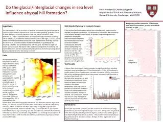
Do the glacial /interglacial changes in sea level influence abyssal hill formation?. Peter Huybers & Charles Langmuir Department of Earth and Planetary Sciences, Harvard University, Cambridge, MA 02138. B athymetry profiles matched to δ 18 O changes,

Hypothesis:
E N D
Presentation Transcript
Do the glacial/interglacial changes in sea level influence abyssal hill formation? Peter Huybers & Charles Langmuir Department of Earth and Planetary Sciences, Harvard University, Cambridge, MA 02138 Bathymetry profiles matched to δ18O changes, with the cross-correlation, p-value, and latitude indicated at right. Matching bathymetry to sealevel changes: If the sea level and bathymetry records are to be effectively used to test for changes in magmatic production, it is necessary to account for the uncertainty in the relative timing of these records. A dynamic programming method is Hypothesis: The approximately 100 m variations in sea level associated with glacial/interglacial cycles are equivalent to suppression of 30 m of mantle upwelling, given the factor of three difference in density between water and mantle peridotite. If the geometry of a ridge is approximated as an isosceles triangle, the mean upwelling rate at the base, u, is related to the full spreading rate of the ridge, s, as u=s/2 tanΘ, where Θ is the angle between the leg and base. A deglaciation involving 100 m of sea level rise in 10 ky then implies fractional reductions in upwelling of 6%, assuming a Θ of 45° and spreading rate of 100 mm/year. The effect is larger for slower spreading rates. We expect ridge produced during times of increasing sea level to be thinner and the resulting bathymetry evolved from the spreading center deeper, and vice-versa for decreasing sea level. adopted to identify the relative timing between the two records that maximizes covariance between increasing sea level and deeper bathymetry. One example is shown at right, where the red line is the bathymetry and black the change in δ18O. The deviations from the dashed black line indicate the time adjustments linking the two. Data: We examine the high frequency variations in ridge bathymetry along the East Pacific Rise (EPR) against a δ18O proxy for changes in Pleistocene sea level. Although the faster spreading rate associated with the EPR suggests a lower amplitude signal, it allows for testing of glacial variability using better temporal resolution, given a fixed spatial sampling interval. Bathymetry from along 100 km on either side of the EPR is obtained from the Eastern bathymetry Test Results: A Monte Carlo technique is used to evaluate the significance of the resulting maximum covariances between δ18O and bathymetry. Of the 162 bathymetry profiles tested, 10 are found to have a p-value of less than 0.01 (i.e. more than 99% of the randomly realized values have greater mismatch) and 20 to have a p-value of less than 0.025. Multiple other processes can lead to bathymetric variations, so we would not expect all records to provide a clear signal. Nonetheless, such high rates of positive test results are unlikely if none of the bathymetry records actually covary with changes in sealevel. For comparison, the test was also run using the negative and time reversed versions of the sealevel proxy record. Global Multi-Resolution Topography Data Portal and filtered to remove large-scale trends, sea-mounts, and low-resolution data. Each distinct corridor of bathymetry extending 100km to the East and West of the ridge having 90% or greater data coverage was retained. Distance from the ridge is converted into an approximate time of formation using a spreading rate that scales linearly with latitude. Variability in Pleistocene sea level is estimated using the time rate of change of a composite of many marine calcite δ18O records where timing is estimated using mean sediment accumulation rates. Conclusions: Overall, the abyssal hill geometry provides evidence for modulation of ridge production by glacial/interglacial changes in sea level. Correlations are greatest in the more rapidly spreading southern regions, perhaps because the signal is less distorted by tectonic processes there. However, the relationship between any particular set of records is unclear. Analysis of other regions will be an important next step. Western bathymetry