Download
1 / 60
600 likes | 833 Vues
Macatawa River Watershed: An Overview of Hydrology and Modeling. Dave Fongers Hydrologic Studies Unit Land and Water Management Division, MDEQ 517-373-0210 fongersd@michigan.gov. Overview. Hydrology Effect of urbanization Stability concepts Modeling Hydrologic Hydraulic Examples.

E N D
Macatawa River Watershed:An Overview of Hydrology and Modeling Dave Fongers Hydrologic Studies Unit Land and Water Management Division, MDEQ 517-373-0210 fongersd@michigan.gov
Overview • Hydrology • Effect of urbanization • Stability concepts • Modeling • Hydrologic • Hydraulic • Examples
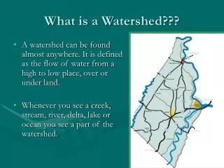
Watershed An area contributing runoff and sediment.
Watershed An area contributing runoff and sediment.
Factors That Affect Discharge • Ease of runoff movement (time of concentration) • Watershed size (delineation) • Soils • Land use • Precipitation • Antecedent moisture • Snow melt • Frozen ground • Spatial extent of storm Human activity can alter these.
24-HourPrecipitationRainfall Frequency Atlas of the Midwest, Bulletin 71, Midwestern Climate Center, 1992 Design Storm
Ease of Water Movement • Time of concentration is the time for runoff to travel from the hydraulically most distant point of the watershed. • Channelization, addition of drains, storm sewers, pavement, graded lawns, and bare soils convey water more rapidly.
Watershed Size 175 square miles
Soils Soils don’t usually change - possible exceptions: clay caps, significant excavations or fills
1978 Land Use The most likely cause of hydrologic change.
1997 Land Use The most likely cause of hydrologic change.
Runoff Calculation Methods • Rational method • Widely used for small drainage areas (less than 100 acres) • Most appropriate for paved areas or watersheds with one uniform land use • Curve number and time of concentration methodology • Developed in 1954 by the NRCS, it is the procedure most frequently used by hydrologists nationwide to estimate surface runoff from ungaged watersheds • Soil type and land use are combined in a single parameter that indicates runoff potential • Regression • Drainage area ratio
Curve Numbers SRO = (P-0.2S)2/(P+0.8S) S = (1000/CN) - 10
Effects of Urbanization Development in a watershed can affect the flow regime - increasing total runoff volume and peak flows.
Hydrograph for a farm on sandy soil or woods on loamy soil. Qp=23 cfs V=5 acre-ft.
Loss of infiltration due to development increases total runoff volume and peak flows. Qp=65 cfs V=11 acre-ft. Qp=23 cfs V=5 acre-ft.
More rapid runoff further increases peak flows. Qp=90 cfs V=11 acre-ft. Qp=65 cfs V=11 acre-ft. Qp=23 cfs V=5 acre-ft.
The altered flow regime affects: • habitat (water velocity, temperature, sediment, other pollutants)
The altered flow regime affects: • habitat (water velocity, temperature, sediment, other pollutants) • flooding (frequency and elevation)
The altered flow regime affects: • habitat (water velocity, temperature, sediment, other pollutants) • flooding (frequency and elevation) • channel morphology
Channel Morphology:the stream’s form and structure: • planform (sinuosity): the shape or pattern of the river as seen from above • cross-section: the shape of the channel at a specific point • profile: the slope of the channel, measured at the water surface or the bottom of the thalweg, the "channel within the channel," that carries water during low flow conditions cross-section planform
Stability Hydrology: a given set of hydrologic conditions (antecedent soil moisture, rainfall, snowmelt, etc.) always cause the runoff from the watershed to respond in a consistent manner in terms of both total volume and peak discharge. Practically, this means the land uses, soils, and drainage patterns within the watershed are not changing. Stream or Channel Morphology: the stream's sinuosity, profile, and cross-sectional dimensions are constant. This does not mean no erosion. It does mean no net change in channel shape which can only occur if the flow regime, especially channel-forming (1- to 2-year) flow, is not changing. Past hydrologic changes can cause stream to be unstable for 60 years or more.
Channel-Forming Flow: a theoretical discharge that would result in a channel morphology close to the existing channel. Extreme flood flows generally have little effect on channel morphology because they are so rare. More frequently occurring flows, those with a 1- to 2-year recurrence interval, are generally the dominant channel-forming flows in stable, natural streams (Schueler, 1987 and Rosgen, 1996). Hydrologic changes that increase these flows can cause the stream to become unstable.
Channel-Forming Flow: a theoretical discharge that would result in a channel morphology close to the existing channel.
Natural Area Watershed Hydrology Stable? Stream Morphology Stable? Yes Yes
Mall under development Watershed Hydrology Stable? Stream Morphology Stable? No ? Appropriate BMPs can be combined to mimic pre-development runoff characteristics.
Mall Watershed Hydrology Stable? Stream Morphology Stable? Yes ? Although the hydrologic characteristics of this drainage area are stable, past changes may continue to destabilize the receiving stream morphology.
Hager Creek Watershed Hydrology Stable? Stream Morphology Stable? Yes No This is an active down-cut. Stability cannot be determined from one photo however.
Stream Instability causes excessive erosion at many locations throughout a stream reach.
Goal of Hydrologic Analysisfor NPS Grants to Control Erosion Assess watershed and stream stability so that proposed solutions will: • address the cause (improve flow regime) • not move the problem to another location • be permanent
General causes of excessive streambank erosion: • Sparse vegetative cover due to too much animal or human traffic. • Concentrated runoff adjacent to the streambank, i.e. gullies, seepage. • An infrequent event, such as an ice jam or low probability flood, damaging a specific streambank. • Unusually large wave action. • A significant change in the hydrologic response of the watershed. • A change in the stream form impacting adjacent portions of the stream, i.e. dredging, channelization.
Hydrologic Modeling • To estimate the peak discharge changes due to changing hydrology • To estimate the size and effectiveness of added detention • Can not demonstrate river stability, although may indicate instability Hydraulic Modeling • To estimate the water surface elevation corresponding to a given flow
Modeling Software • HEC-HMS (Hydrologic Modeling System), HEC-1:combines and routes discharges from multiple subbasins • HEC-RAS (River Analysis System), HEC-2: One-dimensional steady flow water surface profile computations. • TR-55: calculates urban runoff, intended for smaller watersheds of two to three reaches. • TR-20: similar to TR-55 but for intended for whole basin. • SWMM (StormWater Management Model):single event and continuous simulations of water quantity and quality, primarily for urban areas. • Numerous others
Typical Hydrologic Modeling Data • Soils • Land use: historical, current, future • Energy slope of river reaches (can be estimated) • Detention storage-discharge relationship
Sample of model results. 100-Year Storm at C&O, No Detention
Sample of model results. 100-Year Storm at C&O, No Detention compared to 2360 Acre-Feet of Detention
Typical Hydraulic Modeling Data • Discharge • Representative cross-sections • Manning’s roughness coefficient • Energy slope of river reaches (can be estimated)
Spring Exceedence Curve Paul Seelbach, MDNR, has calculated exceedence curves for trout streams. For the Pigeon River watershed, hydrologic modeling was used to compare flows from each subbasin to 4.8 cfs per square mile. 4.8 cfs/square mile (0.0075 cfs/acre)


![Souhegan River Watershed Management Plan Presentation for the [Watershed Community Group] [Date] by Minda Shaheen](https://cdn0.slideserve.com/493641/slide1-dt.jpg)