Download
1 / 6
60 likes | 180 Vues
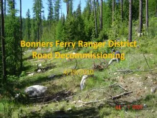
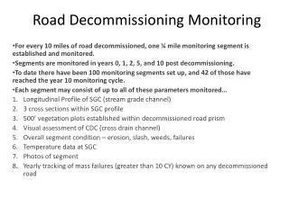
Road Decommissioning Monitoring. For every 10 miles of road decommissioned, one ¼ mile monitoring segment is established and monitored. Segments are monitored in years 0, 1, 2, 5, and 10 post decommissioning.

E N D
Road Decommissioning Monitoring For every 10 miles of road decommissioned, one ¼ mile monitoring segment is established and monitored. Segments are monitored in years 0, 1, 2, 5, and 10 post decommissioning. To date there have been 100 monitoring segments set up, and 42 of those have reached the year 10 monitoring cycle. Each segment may consist of up to all of these parameters monitored… Longitudinal Profile of SGC (stream grade channel) 3 cross sections within SGC profile 500’ vegetation plots established within decommissioned road prism Visual assessment of CDC (cross drain channel) Overall segment condition – erosion, slash, weeds, failures Temperature data at SGC Photos of segment Yearly tracking of mass failures (greater than 10 CY) known on any decommissioned road
Lessons Learned • There are never too many clump plantings on decommissioned roads, especially in channel crossings • Stream bottoms should be constructed at least 2 times bankfull width to allow stream to migrate laterally while minimizing erosion to adjacent slopes • Erosion control mattresses are not necessary in channel bottoms and side slopes to reduce erosion • The use of “brush blankets” has greatly reduced erosion in CDC’s • Spreading “duff” layer from above or below road speeds up the process of establishing native plants and shrubs on decommissioned roads • Slash should be laid on road at approximately 40-60% coverage for optimal reveg • No straw is better than too much straw which will inhibit revegetation • Fertilizer did not increase the rate at which vegetation was established on roads
SGC on rd 75756 Lost Creek drainage decommissioned 2009 Comparison of SGC from year 0 and same site at year 1. Notice the clump plantings where the main alder tree in clump didn’t survive, but all of the shrubs, forbs, grasses that came along in clump are doing very well. And also the areas where the straw was laid down too thick the vegetation is much more sparse if any coming back in those spots.
Culvert Monitoring For each AOP project completed, a monitoring site is set up and monitored in years 0, 1, 5, and 10 post construction There have been 99 monitoring sites set up to date, with 15 having reached year 10 Each monitoring segment consists of: Longitudinal Profile starting 10 times bankfull width above the inlet of structure and ending downstream past point of influence of structure Control cross section set up at beginning of LP, and a tailwater cross section being set up at tailwater control point after outlet Site sketch to include overhead and side view within structure Presence/absence of fish above and below structure Bankfull widths of stream outside zone of influence Substrate size at inlet, middle, and outlet of structure Site photos
Lessons Learned • For AOP, bridge is best option, followed by bottomless arch • Squashed pipes with built in substrate retention structures do not always retain substrate • When at all possible, rock weirs constructed within bottomless arch or under bridges are best option for passage • Planting of fill slopes at inlet and outlet ends helps with stability of slope and creates shade for stream • If using rip rap as fill, cover with soil to allow planting
Rock weirs in Cabin Creek bottomless arch This culvert is 144 feet long with a 6.2% slope. There are a total of 7 rock weirs constructed within structure creating resting pools, habitat, and acting as gradient control structures to optimize passage for all aquatic life.