Exploring Africa's Geography: Mountains, Rivers, and Deserts
100 likes | 219 Vues
Discover the diverse physical geography of Africa, home to the iconic Atlas Mountains, the world's longest river (Nile), and the expansive Sahara Desert. This unit delves into key features such as the Aswan High Dam's role in agriculture and hydroelectric power, and the impacts of desertification in the Sahel region. Explore notable landmarks such as Mount Kilimanjaro and the Great Rift Valley, which connect vital waterways like the Suez Canal to regional power dynamics. Africa's rich natural resources, climatic variations, and historical ecological changes shape its unique landscape.

Exploring Africa's Geography: Mountains, Rivers, and Deserts
E N D
Presentation Transcript
Physical Geography Unit seven – Africa
Longest mountain range in Africa Land north of the mountains are lush and green Atlas Mountains
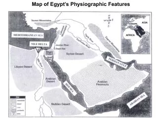
World’s longest river • 90% of Egypt’s population lives along its coastline • Aswan High Dam • Controls flooding • Created Lake Nasser • Provides water for agriculture and hydroelectric pwr. • Destroyed many Egyptian monuments Nile River
Sahara means “desert” in Arabic • In size, it is larger than the continental USA • Most of the Sahara is rocky – (“regs” – rocks, stone) • Summers are hot, winters are cold • Sahel – “edge” “shore” of the desert • Acts as a dividing line between Christianity and Islam • Desertification – process of grasslands turning into desert Sahara desert
A split in the African continent • Supports a wide variety of economic activities • Farmland, fishing, steam, mineral • Mount Kilamanjaro • dormant volcano • Africa’s tallest mountain Great Rift Valley
Connects the Mediterranean to the Red Sea Its creation made Egypt a key regional power Suez Canal
Africa is rich in gold and diamonds This contributed to European interest and colonization Its weak economy and political instability make it difficult to develop these resources Natural Resources
80% of Africa is located in the tropics (between the Tropic of Cancer and Tropic of Capricorn) • Climates are generally warm year round • Africa has two seasons: • Rainy summer season • Dry winter season Climate
Ancient cave drawings show that Northern Africa was once green, lush and rainy • Deserts now cover about 40% of Africa • The Sahara (N.Africa), The Kalahari (S. Africa) Climate continued