Download
1 / 10
100 likes | 221 Vues
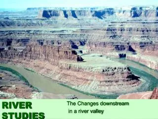
Workshop on Atmospheric Correction of Ocean Color Satellite data in coastal waters: algorithms and uncertainties Wimereux, France, June 13-14 2012. Atmospheric correction in La Plata River challenging turbid waters A. I. Dogliotti; K. Ruddick.

E N D
Workshop on Atmospheric Correction of Ocean Color Satellite data in coastal waters: algorithms and uncertainties Wimereux, France, June 13-14 2012 Atmospheric correction in La Plata River challenging turbid waters A. I. Dogliotti; K. Ruddick Instituto de Astronomía y Física del Espacio (IAFE) CONICET/UBA, Argentina Management Unit of the North Sea Mathematical Models (MUMM) Royal Belgian Institute for Natural Science (RBINS)
Highly turbid waters of La Plata River Estuary • Large scale and shallow (<20m) funnel-shape estuary; • Drains 2nd largest basin SA (22,000 m3/s) • High TSM (100-300 mg/l) • Turbidity front (topography) Characterize Montevideo 300 km Buenos Aires 10 m 100 km 20 m MODIS
869 nm 667 nm 748 nm Sensor Saturation 859 nm 645 nm Red/NIR land bands (250 m) OK 1240 nm 1640 nm 2130 nm SWIR bands (500 m) (Signal in 1240 band) MODIS imagery over La Plata River Red/NIR ocean bands (1 Km)
Atmospheric Correction Algorithms (Dogliotti et al. 2011)
Tind<1.3 Tind(748,1240) (2) AC fixed α(531) (1) SWIR(1240-2130) α(531) NIR/SWIR - F RGB 645 nm
ρw (859) NIR Analysis of AC algorithms 1) Standard NIR approach ρrc(667) ρrc(869) ρrc(748) Fails due to sensor saturation in the 667 and 748 and 869 nm bands which are used in the AC.
ρa (412) ρw (412) SWIR-V SWIR-V Analysis of AC algorithms 2) NIR-SWIR approach (SWIR-V) ρrc(412) Unphysical correlation between the atmospheric product and a marine feature due to non negligible reflectance in the 1240 nm SWIR band.
ρa (412) ρw (412) SWIR-F SWIR-F Analysis of AC algorithms 3) NIR-SWIR approach (SWIR-F) ρrc(412) Spatial distribution of and show no correlation with the highly turbid front
Analysis of AC algorithms Difference between SWIR-V and -F approaches ρFw / ρVw 412 nm The highest ratios were found at the blue bands (~400 nm) and where the most turbid waters are known to occur (B).
Conclusions NASA Standard NIR-based AC approach showed to systematically fail in the turbid waters of La Plata River Standard SWIR approach gives better results, but overestimates in the most turbid parts of the river, thus underestimating marine reflectance (BPA 1240 nm not valid). SWIR-F approach showed to be a good alternative for the more turbid waters (differences were highest in the short wavelengths and lower in the NIR bands). In situ reflectance measurements are needed and are planned in La Plata river to validate AC