Download
1 / 18
180 likes | 362 Vues
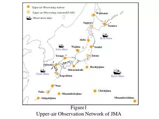
Improvements in the Upper-Air Observation Systems in Japan. M. Ishihara, M. Chiba, Y. Izumikawa, N. Kinoshita, and N. Tsukamoto Japan Meteorological Agency. WMO Technical Conference on Meteorology and Environmental Instruments and Methods of Observation TECO-2006 Geneva

E N D
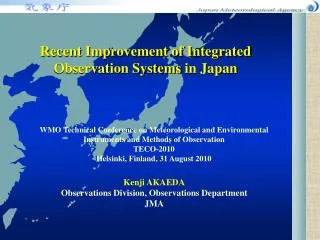
Improvements in the Upper-Air Observation Systems in Japan M. Ishihara, M. Chiba, Y. Izumikawa, N. Kinoshita, and N. Tsukamoto Japan Meteorological Agency WMO Technical Conference on Meteorology and Environmental Instruments and Methods of Observation TECO-2006 Geneva December 3-5, 2006 TECO-2006 Geneva, Dec. 3-5, 2006
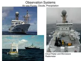
Outline • Background • Operations of wind profilers and Doppler radars • Automatic upper-air observation systems • Experiment on ground-based microwave radiometers for operational use • Operation of GPS-derived IWV Measurement TECO-2006 Geneva, Dec. 3-5, 2006
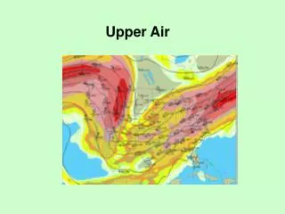
Strategy of JMA for Severe Weather Events Improvement of observations and monitoring Modernization of upper-air observation systems Improvement of forecasting Non-hydrostatic mesoscale model with 4D-VAR data assimilation Enhancement of warning issue Decreasing size of warning areas and extension of warning lead-time TECO-2006 Geneva, Dec. 3-5, 2006
1. Mesoscale Wind Profiler Network 31 wind profilers are being operated at 1357MHz-band, and provide winds aloft from near the surface to about 5 km in height every 10 minutes. Wind Profiler Network and Data Acquisition System (WINDAS) TECO-2006 Geneva, Dec. 3-5, 2006
2. Replacement of conventional radars with Doppler radars • A replacement project from conventional radars to Doppler radars is started in the radar network. • The main purpose of introducing Doppler radars is the assimilation of Doppler velocity data to the numerical weather prediction model, for increasing the accuracy of prediction for mesoscale severe weathers. TECO-2006 Geneva, Dec. 3-5, 2006
Replacement Plan of Weather Radars in JMA • Existing conventional radars • Doppler radars being installed in 2006-2007 , and 2008 • Doppler weather radars being operated for aviation weathers TECO-2006 Geneva, Dec. 3-5, 2006
Impact of Doppler Velocity Data to Numerical Weather Forecast • Assimilation of Doppler velocity data to the mesoscale numerical model using the 4D-VAR was started in 2004. Tokyo Verification of 3-hour accumulated rainfall forecasts starting from 1800 UTC on 1 Feb 2004. (a) 12-15 hour forecast without the assimilation of Doppler velocity data, (b) observation, and (c) forecast with the assimilation (Ishikawa and Koizumi, 2006). Circles indicate heavy rainfall areas. TECO-2006 Geneva, Dec. 3-5, 2006
3. Introduction of Automatic Upper-air Observation Systems • Manned stations • Automatic radiosonde observation systems being started in 2003-2006 , and 2007 TECO-2006 Geneva, Dec. 3-5, 2006
Automatic Upper-air Observation Systems MINAMIDAITOJIMA (2005) HACHIJOJIMA (2003) ISHIGAKIJIMA (2006) TECO-2006 Geneva, Dec. 3-5, 2006
Automatic Radiosonde Observation Systems Being Suitable for Our Operation • The ballon-launching gear of the system was improved after the installation to endure to strong wind and high humidity at 47678. • 600g balloons with internal parachutes are used at 47918. • Some balloons had been tore in the storage room of the system due to surface ozone at 47918. An air- filter was installed stop the inflow of ozone from the outside, and then the problem was resolved. • An unmanned hydrogen generator will be used at 47909 from 2007. TECO-2006 Geneva, Dec. 3-5, 2006
4. Experiments of Ground-based Microwave Radiometers for Operational Use • JMA starts a project for operational use of ground-based microwave radiometers. • Field experiments are being made in some different climate conditions of Japan; in sub-tropics, in summer and winter at the mid-latitudes. • Two methods; the built-in algorisms and the 1D-VAR with the mesoscale model, are being tested to retrieve temperature and humidity profiles. TECO-2006 Geneva, Dec. 3-5, 2006
Field Experiments of ground-based Microwave Radiometers in 2006-2007 Oct. to Dec., RPG HATPRO August to Dec., RDX WVP-3000 June to July, RDX WVP-3000 July to Sep., RPG HATPRO July to Dec., RDX WVP-3000 Morioka Niigata Sendai Tsukuba Naha April to May and Jan. 2007, RDX WVP-3000 Jan. 2007., RPG HATPRO Radiometric TP/WVP-3000 Radiometer Physics GmbH HATPRO TECO-2006 Geneva, Dec. 3-5, 2006
A topic in the field experiment; the radiometer measurements with the rainfall mitigation system, and in this case, temperature and water vapor profiles was obtained in good accuracy even in strong rain as well as in light rain. light rain strong rain TECO-2006 Geneva, Dec. 3-5, 2006
5. Operational Measurement of GPS-derived Integrated Water Vapor (IWV) • The operational measurement of integrated water vapor (IWV) measurement using the GPS receiver network (GEONET) of the Geophysical Survey Institute (GSI) has been planned. • However, the information on the orbits and the clocks of the GPS satellites, which are needed to calculate IWV, are not available in real-time. TECO-2006 Geneva, Dec. 3-5, 2006
The meteorological Institute of JMA (MRI) has developed a near-real time processing scheme. Using the ultra-rapid information and the GPS clocks corrected by the accurate clock of an International Global Navigation Satellite System Service (IGS) station. • The scheme provides enough accuracy of integrated water vapour (IWV) for assimilation to NWP. • JMA is going to make a contract with the Geophysical Survey Institute (GSI)to obtain the GPS network data in real-time probably in 2007. Near-real Time Processing of IWV TECO-2006 Geneva, Dec. 3-5, 2006
Near-real Time Processing of IWV 1) Using the rapid orbit, the error on the most accurate clock in a GPS station of Japan (Usuda) is estimated. The error is extrapolated in the next 24 hours. Accuracy Final Orbit after 2 weeks Rapid Orbit after 12 - 36 hours 2) Using the corrected time of Usuda, errors on the clocks of the GPS satellites are corrected. Ultra-Rapid Orbit (observed half) after 2 - 8 hours Ultra-Rapid Orbit (Predicted half) before 24 hours 3) Using the corrected GPS satellite clocks and the ultra-rapid orbit, IWV is estimated at the each GPS stations. Rapidity (Shoji and Kunii, 2006) TECO-2006 Geneva, Dec. 3-5, 2006
Radar Echo IWV Flux Convergence 05UTC 05UTC 06UTC 06UTC FLUX CONV (kg m-2s-1) Convection nowcasting using horizontal water vapor flux convergence using GPS integrated water vapour (IWV) and surfade winds from the AWS network (AMeDAS). TECO-2006 Geneva, Dec. 3-5, 2006
Issues and Future Plans • Re-construction of radiosonde observation network using automatic systems including positive and negative targeting, • Vertical profiling of water vapor from microwave radiometers, GPS occultation method, wind profilers, • Upper-air observations over the ocean. TECO-2006 Geneva, Dec. 3-5, 2006