Download
1 / 5
50 likes | 189 Vues
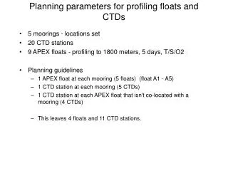
This document outlines the strategic planning parameters for deploying profiling floats and Conductivity-Temperature-Depth (CTD) stations across five moorings in the Gulf Stream region. It details the placement of nine APEX floats, each designed to profile to depths of 1800 meters, and specifies the collection of vital oceanographic data (Temperature/Salinity/Oxygen) over a five-day period. The plan includes specific locations for CTD stations and recommendations for additional floats and stations based on sea surface temperature and altimetry data, ensuring optimal sampling coverage.

E N D
Planning parameters for profiling floats and CTDs • 5 moorings - locations set • 20 CTD stations • 9 APEX floats - profiling to 1800 meters, 5 days, T/S/O2 • Planning guidelines • 1 APEX float at each mooring (5 floats) (float A1 - A5) • 1 CTD station at each mooring (5 CTDs) • 1 CTD station at each APEX float that isn't co-located with a mooring (4 CTDs) • This leaves 4 floats and 11 CTD stations.
Parameters (continued) • Placement of additional 4 floats: • A6: 1 float on outbound track just south of Gulf Stream • A7: 1 float on outbound track halfway between moorings C and B • A8: 1 float on inbound track (between Bermuda and mooring F) at climatological deepest location of 17C isotherm • A9: 1 float on inbound track just north of Gulf Stream (?) • Placement of additional CTD stations: • Sampling across southern half of Gulf Stream on outbound track: 4 stations additional. Positions to be based on SST and altimetry maps • Sampling across southern half of Gulf Stream on inbound track: 4 stations additional. Positions to be based on SST and altimetry maps (other info? XBT sections?) • 3 other stations • 1 between moorings D and C: 37N 58.5W • 1 between moorings B and A: 32.5N 57W • 1 between mooring A and Bermuda: 31.5N 62W
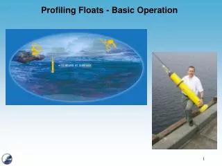
APEX floats with Seabird T/S and Aanderaa optode oxygen sensor * CTD stations