Download
1 / 28
290 likes | 452 Vues
GGE5083 : Hydrographic Field Operations 2002 Overview, Course Outline http://www.omg.unb.ca/GGE/SE_5083.html. John E. Hughes Clarke OMG/UNB jhc@omg.unb.ca 506-453-4568. IHO Category-A Hydrographic Surveyor (GGE Elective in Hydrography). GGE5072 Hydrographic Data Management Wells.

E N D
GGE5083 : Hydrographic Field Operations 2002 Overview, Course Outline http://www.omg.unb.ca/GGE/SE_5083.html John E. Hughes Clarke OMG/UNB jhc@omg.unb.ca 506-453-4568
IHO Category-A Hydrographic Surveyor (GGE Elective in Hydrography) GGE5072 Hydrographic Data Management Wells 2002+ GGE3353 Imaging and Mapping II Hughes Clarke GGE5013 Coastal Oceanography and Tides Hughes Clarke and Wells + GGE5083 Hydrographic Field Operations Hughes Clarke GGE4042 Kinematic Positioning Santos GGE4512 Land Administration II (Oceans) Nichols GGE – Basic Geodesy and GIS Various GEOL4501 Exploration Geophysics I Butler GEOL4512 Exploration Geophysics II Butler
Minimum Requirements for IHO Category A • Academic Certificate is: • “3 weeks field operations” • This is it. • Enrolled Students: • Andreas Adam • Claudia Luebke • Kevin Grey • Karen Cove • + UGEX – Melbourne ?
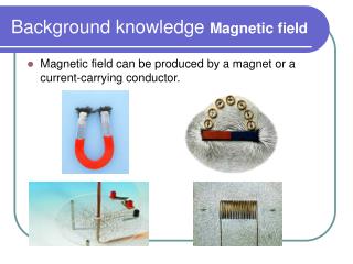
RV Mary-O 43ft Cape Island Knudsen 320B/P RDI ADCP CSL Plover 31ft P-boat Simrad EM3000S CSL Heron 34ft H-boat Simrad EM3000S Knudsen 320B/P RDI ADCP
Sonar Equipment: • Simrad EM3000S – Seatex MRU-6 • Knudsen 320B/P • 200 kHz 0.5 º port sidescan • 200 kHz 0.5 º stbd. Sidescan • 200 kHz 6º downward • Knudsen 320M • 28 kHz subbottom • 3.5 KHz subbottom • RDI ADCP – 600 kHz • Datasonics Chirp
3m Fredericton Cumberland Basin 13m Long Reach and Kennebecasis Saint John Minas Basin Passamaquoddy Bay 10m 16m BAY OF FUNDY 8m Bedford Basin St. Margarets Bay 7m Digby Basin Mahone Bay 6m 2m La Have River SCOTIAN SHELF Xm : tidal range
GGE5083 -2001 Musquash Estuary Simrad EM3000 multibeam backscatter Simrad EM3000 multibeam bathymetry 1000m
Inner Passamaquoddy Bay St. Croix Estuary GGE5083 Vicinity of St. Andrews-by-the-sea Regional Multibeam Coverage EM1000 – 1992 EM1000 –1994 EM1000 -1995 DOWNTOWN Outer Passamaquoddy Bay 5000m
GGE5083 St. Andrews-by-the-sea Planned Survey Extent 1000m
Survey Requirements: • Multibeam: 100% coverage below LWT (bathymetry AND backscatter) Special Order to 20m Order 1 thereafter • Datums: horiz.: WGS 84, vertical: CHS Chart datum • Sidescan : search for targets amongst moorings reconnaisance of intertidal zone • Subbottom : 50m line spacing (28 kHz and 3.5 kHz) • ADCP : time series over full tidal cycle for E and W harbour entrances Multibeam, Sidescan and Subbottom all collected within 2 hours of HW.
Survey Requirements: • Multibeam: 100% coverage below LWT (bathymetry AND backscatter) Special Order to 20m Order 1 thereafter • Datums: horiz.: WGS 84, vertical: CHS Chart datum • Sidescan : search for targets amongst moorings reconnaisance of intertidal zone • Subbottom : 50m line spacing (28 kHz and 3.5 kHz) • ADCP : time series over full tidal cycle for E and W harbour entrances Multibeam, Sidescan and Subbottom all collected within 2 hours of HW.
Survey Requirements: • Multibeam: 100% coverage below LWT (bathymetry AND backscatter) Special Order to 20m Order 1 thereafter • Datums: horiz.: WGS 84, vertical: CHS Chart datum • Sidescan : search for targets amongst moorings reconnaisance of intertidal zone • Subbottom : 50m line spacing (28 kHz and 3.5 kHz) • ADCP : time series over full tidal cycle for E and W harbour entrances Multibeam, Sidescan and Subbottom all collected within 2 hours of HW.
Survey Requirements: • Multibeam: 100% coverage below LWT (bathymetry AND backscatter) Special Order to 20m Order 1 thereafter • Datums: horiz.: WGS 84, vertical: CHS Chart datum • Sidescan : search for targets amongst moorings reconnaisance of intertidal zone • Subbottom : 50m line spacing (28 kHz and 3.5 kHz) • ADCP : time series over full tidal cycle for E and W harbour entrances Multibeam, Sidescan and Subbottom all collected within 2 hours of HW.
Survey Requirements: • Multibeam: 100% coverage below LWT (bathymetry AND backscatter) Special Order to 20m Order 1 thereafter • Datums: horiz.: WGS 84, vertical: CHS Chart datum • Sidescan : search for targets amongst moorings reconnaisance of intertidal zone • Subbottom : 50m line spacing (28 kHz and 3.5 kHz) • ADCP : time series over full tidal cycle for E and W harbour entrances Multibeam, Sidescan and Subbottom all collected within 2 hours of HW.
Possible Extra Programs: • Reference Surface – establishment and testing of: • Seatex Seapath 200-RTK • Applanix POS/MV 320 V.3 • CCGS Hart • Geophysical surveys with Geological Survey of Canada • Seistex Boomer • Datasonics Chirp • Simrad MS972 towed sidescan • Grabs, cameras, USBL. • Regional Surveys as dictated during LW periods • Extension of pockmark operations • T/S profiling of St. Croix Estuary.
Course Instructors: • OMG Faculty • John E. Hughes Clarke • Marcelos Santos • OMG System Manager • Xuan (Shawn) Woo • OMG Research Assistant • Anya Duxfield • OMG Graduate Students • Garret Duffy • Jonathan Beaudoin
Fredericton Power and Sail Squadron • Instructors: • Rik Hall • David Estey • David Nickerson • Basic Seamanship January-February • Marine Pilotage March-April • Tuesday Evenings 1830-2130 (630-930pm) • COST C$300 – paid by OMG for Y2002
Term- Time Tasks: • Establish Tide Gauge on St. Andrews Pier • Establish DGPS-RTK base station (probably on Community College Roof) • Ensure all comfortable with operation of Ashtech Z-12’s and Trimble 5700’s • Collate SNB Orthophoto Coverage • Collate SNB Vector Data Information • Collate CHS Chart-inset Data • Prepare detailed plan of operations • Training in SwathEd processing 1997 EM3000 St. Andrews harbour Meet weekly Friday 1200 To review progress