Download
1 / 24
240 likes | 418 Vues
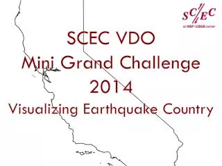
Mini Grand Challenge. Lindsay Arvin Daniel Philo Ryan Meier Jing Yuan Kelvin Vasquez Ngoc Kiem. Outline. How the San Andreas is not strictly a strike-slip fault. Why the San Andreas can be divided into segments.

E N D
Mini Grand Challenge Lindsay Arvin Daniel Philo Ryan Meier Jing Yuan Kelvin Vasquez Ngoc Kiem
Outline • How the San Andreas is not strictly a strike-slip fault. • Why the San Andreas can be divided into segments. • How the major segments of the San Andreas have different recurrence intervals. • What is the big bend and why is it important • How the San Gorgonio Pass is an earthquake “traffic jam”. • How the extensional forces cause the Salton Trough.
Transform Faults (1) (2)
References “Earth’s crust: transform faults.” Art. Encyclopædia Britannica Online. Web. 20 Jun. 2013. <http://www.britannica.com/EBchecked/media/1178/Two- transform-faults-offsetting-a-mid-oceanic-ridge>. "Geologic History of the San Andreas Fault System." Western Region Geology and Geophysics Science Center. United States Geological Survey, 26 May 2006. Web. 20 June 2013. <http://geomaps.wr.usgs.gov/archive/socal/geology/geologic_history/san _andreas_history.html>. 3. "Southern California Is Earthquake Country." Earthquake Country. Southern California Earthquake Center, n.d. Web. 20 June 2013. <http://www.earthquakecountry.info/roots/socal.html>.
Segments of the San Andreas Fault • Historically, the San Andreas has been divided up into individual fault segments that range from tens to hundreds of kilometers. • These include the Big Bend, Coachella, & Parkfieldfault segments. Several segments of the San Andreas fault in Southern California.
Segments of the San Andreas Fault • The San Andreas can be divided up into three larger segments as well. • Southern, Central, and Northern. • Complex fault geometries of the Southern and Northern allow for large earthquakes (Li and Liu, 2006). • Central segment is dominated by aseismic creep. The trace of the San Andreas fault in California (Lynch, 2006).
References Lynch, David, 2006. “Can San Andreas Break At Once? Study Says Maybe.” KPBS. < http://www.kpbs.org/news/2013/jan/10/can-san- andreas-break-once-study-says-maybe/> Li, Q., and M. Liu, 2006, Geometrical impact of the San Andreas Fault on stress and seismicity in California, Geophysical Research Letters, 33,L08302, doi:10.1029/2005GL025661
Recurrence Intervals • Frequency – Average time between past seismic events • aka “recurrence interval” • Recurrence Interval = Average slip per major rupture / Slip Rate Quote: The next large earthquake on the southern San Andreas Fault could affect 10 million people or more. “It could (The Big One) be tomorrow or it could be 10 years or more from now” -Yuri Fialko, September 2005
Prediction vs. Forecasting • Recurrence Intervals – Past occurrence of random events. • Prediction – Determining the hazard of seismic activity of given areas is important to predict future occurrences. • Forecasting - Future likelihood of random events. • Using probability of seismic activity occurring in a given area during a given time • Assessing both the slip rate of the fault and the risk the fault presents
Recurrence Intervals Segments • Northern Segment • Average slip rate (1.3 – 1.5 inches per year) • Meaningful average recurrence interval 200 with an uncertainty of 50 years • 1906 San Francisco Earthquake 7.8M • Central Segment • Aseismic creep – slips continuously without causing earthquakes • 1857 Fort Tegon Earthquake 7.9M • Few exceptions i.e. Parkfield • Southern Segment (Mojave Segment) • Average slip rate (1.3 – 1.5 inches per year) • Meaningful average recurrence interval 200 with an uncertainty of 50 years • No major earthquake in over 250 years *(1680 7.7M) • YIKES! Fun Fact: Probable Magnitudes on the SAF are MW6.8 - 8.0 (Hang on!) Creeping at Hollister, CA
Furnal, Thomas E., Silvio K. Pezzopane, Ray J. Weldon, II, and David P. Schwartz. "A 100-Year Average Recurrence Interval for the San Andreas Fault at Wrightwood, California." Science 259 (1993): n. pag. Science. Web. "Information and Resources about the San Andreas Fault." Information and Resources about the San Andreas Fault. Ed. David K. Lynch. N.p., 2009. Web. 17 June 2013. Nester, Irene K. "San Andreas Transform Fault Zone." San Andreas Transform Fault Zone. Emporia State University, 25 Apr. 2008. Web. 13 June 2013. <http://academic.emporia.edu/aberjame/student/nester1/sandreas.htm>. Richardson, Eliza. "Different Methods for Determining Recurrence Interval." Welcome to the Dutton E-Education Institute!Pennsylvania State University, n.d. Web. 14 June 2013. <https://www.e- education.psu.edu/earth501/content/p4_p8.html>. References
San Andreas Big Bend • A geometric feature • Restraining the relative plate motion • Nature’s solution • Impacts include: • patterns of faults, seismicity • Rupture propagation • Possibility of multi-faultruptures • …
Garlock Fault (King et al, 1985)
Garlock Fault (King et al, 1985)
Big Bend Evolution (Dolan et al, 2007)
Reference King, G., Nábělek, J., 1985, Role of Fault Bends in the Initiation and Termination of Earthquake Rupture Asperity and Barriers, Science, Vol. 228, No. 4702, pp. 984-987 Dolan, J., Bowman, D., Sammis, C., 2007, Long-range and long- term fault interactions in Southern California, Geology, v. 35 no. 9 p. 855-858 Li, Q., Liu, M., 2006, Geometrical impact of the San Andreas Fault on stress and seismicity in California, Geophysical Research Letters, Vol 33, L08302
San Gorgonio Pass • Largest discontinuity along the San Andreas fault • San Andreas fault slip decreases to a minimum of 5–10 mm/yr at the SGP, from 24 ± 3.5 mm/yr at Cajon Pass on the northwest and 12–22 mm/yr at Indio on the southeast • The San Andreas fault curves abruptly southward from its normal southeast trend and butts into the eastward-trending Banning fault at 45
Active and Inactive Faults Traces of active faults are show in red Inactive faults are shown in black Beach-balls show epicenter and oblique slip during earthquakes on the north-dipping San Gorgonio Pass–Garnet Hill fault system at depth Stars show epicenter of earthquakes on faults outside of San Gorgonio Pass
References Allen C.R. 1957, San Andreas fault zone in San Gorgonio Pass, Southern California: Geological Society of America Bulletin, v. 68, p. 315– 350, doi: 10.1130/0016- 7606(1957)68[315:SAFZIS]2.0.CO;2. Cooke, M. L., & Dair, L. C. (2011). Simulating the recent evolution of the southern big bend of the san andreas fault, southern california. Journal of Geophysical Research.Solid Earth, 116(4) doi:http://dx.doi.org/10.1029/2010JB007835 "The Enigmatic San Gorgonio Pass." The Enigmatic San Gorgonio Pass. University Of Southern California, Feb. 2009. Web. 20 June 2013.
Salton Trough • Salton Trough area : • Coachella • Imperial Valleys • Western half of the Mexicali Valley • The Colorado River Delta in Mexico • Formation : • Small scale : A complex transition zone between the right-lateral motion of the San Andreas transform fault system, and the northwestward progressing spreading ridge complex of the Gulf of California segment. • Large scale: A deep sedimentary basin formed by the extensional forces associated with an underlying tectonic plate boundary.
Physical Features and Characteristics of the Salton Trough Area • A graben is a strip of land bounded on opposite sides by roughly parallel faults. Through movement of the faults, the strip of land sinks in a process called subsidence. • The region around the south San Andreas fault is actively being stretched due to extensional deformation. Numerous faults, high levels of seismicity and a series of young volcanic buttes suggest this region may be a source for future geo-hazards
References Alles, David L. "Geology of the Salton Trough." Western Washington University, 28 Oct. 2011. Web. <http://fire.biol.wwu.edu/trent/alles/GeologySaltonTrough.pdf>. "Salton Sea Tectonic Research." Salton Sea Tectonic Research. Scripps Institution of Oceanography, 1 June 2010. Web. 20 June 2013. <http://quakeinfo.ucsd.edu/~dkilb/NG/SaltonSea/Introduction.html >. Viento, Pasar. "Garben Laguna Salada by the Horns." Geocaching. Groundspeak, 14 July 2007. Web. 20 June 2013. <http://www.geocaching.com/seek/cache_details.aspx?guid=a9e0022c- ee64-4a24-9c7d-afc3a5830a8c>.