Download
1 / 42
420 likes | 559 Vues
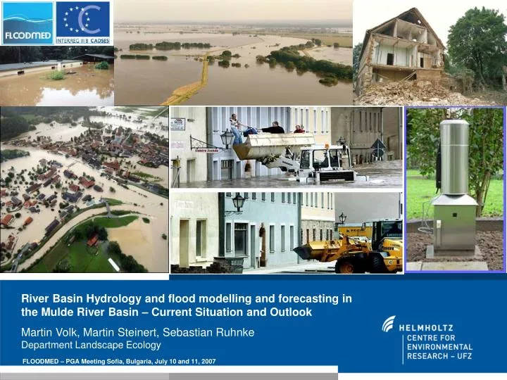
River Basin Hydrology and flood modelling and forecasting in the Mulde River Basin – Current Situation and Outlook Martin Volk, Martin Steinert, Sebastian Ruhnke Department Landscape Ecology. FLOODMED – PGA Meeting Sofia, Bulgaria, July 10 and 11, 2007. Overview. 1. Objectives

E N D
River Basin Hydrology and flood modelling and forecasting in the Mulde River Basin – Current Situation and Outlook Martin Volk, Martin Steinert, Sebastian RuhnkeDepartment Landscape Ecology FLOODMED – PGA Meeting Sofia, Bulgaria, July 10 and 11, 2007
Overview 1. Objectives 2. The Mulde River Basin 3. Current Flood Protection Measures 4. Modelling Approach and First Results 5. Conclusions and Outlook FLOODMED – PGA Meeting Sofia, Bulgaria, July 10 - 11, 2007
1. Objectives i) Options for runoff (and flood) mitigation by land use changes in a medium to large river basin? (WFD) - Is it possible to simulate that? - Investigate the current situation! ii) Which methods for the smaller scale? - Inundation model (Linkage?) FLOODMED – PGA Meeting Sofia, Bulgaria, July 10 - 11, 2007
2. The Mulde River Basin: Altitudes Altitudes: < 50 m to over 1100 m a.s.l. FLOODMED – PGA Meeting Sofia, Bulgaria, July 10 - 11, 2007
2. The Mulde River Basin: Soils Altitudes: < 50 m to over 1100 m a.s.l. - Many soils with low to middle hydrologic conductivity / permeability FLOODMED – PGA Meeting Sofia, Bulgaria, July 10 - 11, 2007
2. The Mulde River Basin: Land Use Farmland: 60% Forest: 17% Urban: 10% Pasture: 10% Others: 3% - Altitudes: < 50 m to over 1100 m a.s.l. - Many soils with low to middle hydrologic conductivies - Land Use: Mainly agricultural, settlement areas in the valleys (steep valleys in mountains) FLOODMED – PGA Meeting Sofia, Bulgaria, July 10 - 11, 2007
2. The Mulde River Basin: Characteristics of the Natural Regions - Less permeable soils in the Upper River Basin, steep valleys FLOODMED – PGA Meeting Sofia, Bulgaria, July 10 - 11, 2007
2. The Mulde River Basin: Floods FLOODMED – PGA Meeting Sofia, Bulgaria, July 10 - 11, 2007
2. The Mulde River Basin: The Flood of 2002 • August 12-14, 2002: Vb weather condition • Partly 350 l / m² rainfall in 24 hours! FLOODMED – PGA Meeting Sofia, Bulgaria, July 10 - 11, 2007
2. The Mulde River Basin: The Flood of 2002 FLOODMED – PGA Meeting Sofia, Bulgaria, July 10 - 11, 2007
2. The Mulde River Basin: The Flood of 2002 „1000- to 200-year“ flood Saxony „200- to 100-year“ flood Saxony-Anhalt FLOODMED – PGA Meeting Sofia, Bulgaria, July 10 - 11, 2007
2. The Mulde River Basin: The Flood of 2002 „1000- to 200-year“ flood Saxony „200- to 100-year“ flood Saxony-Anhalt
2. The Mulde River Basin: The Flood of 2002 FLOODMED – PGA Meeting Sofia, Bulgaria, July 10 - 11, 2007
Damage: - 21 people lost their lifes - around EUR 6 billion only in Saxony
2. The Mulde River Basin: The Flood of 2002 FLOODMED – PGA Meeting Sofia, Bulgaria, July 10 - 11, 2007
2. The Mulde River Basin: The Flood of 2002 FLOODMED – PGA Meeting Sofia, Bulgaria, July 10 - 11, 2007
3. Current Flood Protection Measures Flood Protection Measures, Monitoring, Modelling (Development since flood of 2002) FLOODMED – PGA Meeting Sofia, Bulgaria, July 10 - 11, 2007
3. Current Flood Protection Measures FLOODMED – PGA Meeting Sofia, Bulgaria, July 10 - 11, 2007
3. Current Flood Protection Measures Sächsische Landesanstalt für Landwirtschaft, Fachbereich 3, Referat 34, 2005 Retention reservoir Blumenau/Olbernau 2003 22,000 EUR 190 m3 FLOODMED – PGA Meeting Sofia, Bulgaria, July 10 - 11, 2007
3. Current Flood Protection Measures Staatliches Amt für Ländliche Entwicklung Kamenz, 1998 Sächsische LfL, Fachbereich 3, Referat 34, 2005 „Mill pond“ (Catchment ~ 5km2) Günthersdorf 1998 40,500 EUR fire pond and flood protection FLOODMED – PGA Meeting Sofia, Bulgaria, July 10 - 11, 2007
3. Current Flood Protection Measures Staatliches Amt für Ländliche Entwicklung Kamenz, Abteilung 3, Referat 34, 2003 Planting Erbrichterhaus Obercarsdorf 2003 9,800 EUR Field hedge ca. 300 m x 10 m FLOODMED – PGA Meeting Sofia, Bulgaria, July 10 - 11, 2007
3. Current Flood Protection Measures, Monitoring and Modelling Since 2002 Standard in Saxony: Flood gauges with remote data transmission; flood level messages automatically via telephone and GSM (81 gauges with redundant instrumentation) – costs EUR 7.5 Mio. Further important component: Automatic precipitation measuring network of 22 ombrometers (costs: EUR 420,000). The ombrometers are arranged in flood runoff generation areas. Densification of Governmental precipitation measuring network (German Weather Service). Sophisticated rainfall-runoff model is planned – EUR 65,000; modify existing model (covers not the entire basin) plus adaptation to existing Elbe River model: EUR 40,000. New forecasting model is planned which should include hydro-dynamic model FLOODMED – PGA Meeting Sofia, Bulgaria, July 10 - 11, 2007
4. Modelling Approach Inundation model: TRIMR2D River Basin Model: SWAT FLOODMED – PGA Meeting Sofia, Bulgaria, July 10 - 11, 2007
4. Modelling Approach: TRIMR2D TRansient Inundation Model for Rivers – 2Dimensional (TRIMR2D) • developed by Casulli (1990), modified for rivers by Walters (1998) • solves the two-dimensional depth-averaged flow equations • uses a semi-implicit, semi-Lagrangian finite-difference method • based on the TRIM estuarine model (Casulli, 1990; Cheng et al., 1993) • TrimR2D is dedicated of computing large local changes in water-surface, elevation and velocity • the implemented Finite-difference schemes subdivide the model area into a discrete number of nodes and solve the flow equations at each node (Jones et al., 2002) FLOODMED – PGA Meeting Sofia, Bulgaria, July 10 - 11, 2007
4. Modelling Approach: TRIMR2D • Input data: • (sub)hourly stream flow time series (discharge values [m³/sec]) • Point Sources Inputs; • High precision elevation layer; • Land use layer (information about surface roughness) • (optional: wind speed and direction data – not used in the numerical solution) • Output: • water level (m), • flow velocity (ms-1) FLOODMED – PGA Meeting Sofia, Bulgaria, July 10 - 11, 2007
4. Modelling Approach: TRIMR2D Application • At the moment the model is used in a project (http://www.hochwasser-dresden.de/3ZMGRIMEX), where different models from groundwater, sewage water and surface water were coupled. • USGS use TRIMR2D in the real time flood forecasting (Chattahoochee and Snowqualmie River). • The original model TRIM was used and modified by the German Federal Waterways Engineering and Research Institute to investigate coastal and estuarine flows. FLOODMED – PGA Meeting Sofia, Bulgaria, July 10 - 11, 2007
Bad Düben Golzern
4. Modelling Approach: TRIMR2D – First results FLOODMED – PGA Meeting Sofia, Bulgaria, July 10 - 11, 2007
4. Modelling Approach: TRIMR2D – First results FLOODMED – PGA Meeting Sofia, Bulgaria, July 10 - 11, 2007
4. Modelling Approach: TRIMR2D – First results FLOODMED – PGA Meeting Sofia, Bulgaria, July 10 - 11, 2007
4. Modelling Approach: TRIMR2D – First results FLOODMED – PGA Meeting Sofia, Bulgaria, July 10 - 11, 2007
4. Modelling Approach: TRIMR2D – First results FLOODMED – PGA Meeting Sofia, Bulgaria, July 10 - 11, 2007
4. Modelling Approach: TRIMR2D – First results FLOODMED – PGA Meeting Sofia, Bulgaria, July 10 - 11, 2007
4. Modelling Approach: TRIMR2D – First results • Reasonable results – but: • Only low resolution DEM available (20 m) • LIDAR data are required • river cross profiles are required • Distributed surface roughness coefficient Manning`s n is required • co-operation with authorities is complex (very sensitive topic!!!) FLOODMED – PGA Meeting Sofia, Bulgaria, July 10 - 11, 2007
4. Modelling Approach: SWAT Soil and Water Assessment Tool (SWAT) Developed by USDA, beginning in 1995, as a distributed, physically based model designed to: “predict the impact of land management practices on water, sediment and agricultural chemical yields in large complex watersheds with varying soils, landuse and management conditions over long periods of time.” FLOODMED – PGA Meeting Sofia, Bulgaria, July 10 - 11, 2007
4. Modelling Approach: SWAT Continuous Time - Daily Time Step (Sub-hourly) - One Day - Hundreds of Years Distributed Parameter - Unlimited Number of Subwatersheds Comprehensive – Process Interactions Simulate Management FLOODMED – PGA Meeting Sofia, Bulgaria, July 10 - 11, 2007
4. Modelling Approach: SWAT Sensitivity Analysis (LH-OAT; A. van Griensven) Manual andAutomated Calibration (ParaSol;; modified Shuffled complex evolution algorithm; A. van Griensven) FLOODMED – PGA Meeting Sofia, Bulgaria, July 10 - 11, 2007
4. Modelling Approach: SWAT – First Results Suitable precip stations? Disturbances?
4. Conclusions and outlook TRIMR2D: • Some measures will be implemented to check the results (under the poor conditions) • Model will be applied at other location with better database to show the potential SWAT: • Impact of precip stations will be checked (rainfall distribution) • Problem: Regulated river basin (drainage tiles, reservoirs, retention basins), impact has to be investigated • Sensitivity analysis and calibration to be continued
„All models are wrong – but which are the best ones for which scale?“