Comprehensive Methods for Data Collection in Coastal and Oceanographic Monitoring
This document outlines the essential data collection needs and methods for monitoring shore and ocean environments. It addresses various parameters like waves, water levels, meteorological conditions, and oceanographic data. Emphasizing the importance of both long-term and rapidly deployed measurement systems, the text details various instruments such as NOAA buoys, tide gauges, and autonomous sensors. Additionally, it discusses the advantages of using satellite data and new types of measurement systems. Key questions on implementation, funding, and strategic integration of these measurements are also explored.

Comprehensive Methods for Data Collection in Coastal and Oceanographic Monitoring
E N D
Presentation Transcript
Needs • Waves, water levels, runup • Offshore, coastal, onshore • Meteorological parameters • Winds, pressure, precipitation, temperature • Oceanographic parameters • Temperature, salinity, water quality parameters • Streamflow • High resolution topography/bathymetry
Outline • Permanent measurement systems • Rapidly deployed measurement systems • Possible new types of measurement systems
Long Term Measurement Systems • Satellite • Atmospheric stations • NOAA buoys • Tide Gauges • New Permanent Nearshore Stations • Temporary instruments deployed for hurricane season • Shore and/or Ocean – Based • Video: Argus-type
Rapidly Deployed Measurement Systems • Airplane – based • Hurricane hunters: pressure, winds, dropsondes • Scanning Radar Altimeter • Land – based • Water levels, waves, runup • Wind/atmospheric • Possibility of real-time data • Ocean – based • Bottom-mounted: Waves/water levels, currents, salinity • Surface drifting sensors • Autonomous sensors/gliders
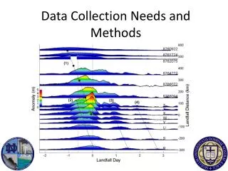
Hurricane Gustav • 20 gauges from LA-TX border to FL panhandle • 18 recovered – 16 of 18 good data New Orleans Far east Landfall and strong side West of Landfall Hurricane Gustav
Hurricane Ike 42035 • 9 Gauges Corpus Christi to TX-LA border • 8 retrieved with good data • Some Gustav gauges recorded part of storm
Atlantic Ocean RodantheBreach SR-8 Rodanthe Pier 2.4 km SR-3 Jennette’s Pier 35 km SR-4 Oceanfront New NewBreach 9 km SR-6 Mid-Island 250m SR-1 Soundside Pamlico Sound
Instruments Base(25kg) Float AcousticBeacon Inexpensive Self-Recording Pressure Gauge
Float for retrieval Deployment Instruments • 5-10 bases at a time, depending on helicopter • 10-20 deployments in a day, depending on conditions • Requires good prior connections with helicopter companies 15” Helicopter training for deployment Bases packed for deployment
New Types of Measurement Systems • Shore (pier) or platform – mounted laser wave gauges • Single beam or scanning • Inexpensive drifting wave gauges with one-way satellite communications • Also other oceanographic information • Could have fleets
Questions • What is needed? • Where? • How will measurements best fit into the overall strategy? • What is possible? • Who pays for instruments plus deployment/retrieval/upkeep?