Download
1 / 41
410 likes | 443 Vues
This agenda outlines the objectives and action points for the Critical Infrastructure and Key Resources Subcommittee meeting of the Connecticut GIS Council on June 15, 2010. The primary focus is on evaluating and improving GIS data related to critical infrastructure and key resources, discussing data security protocols, identifying data issues, and coordinating with relevant stakeholders at different government levels. The subcommittee aims to enhance the State Geographic Emergency Management System (GEMS) by ensuring robust data standards and maintenance protocols. The agenda also covers the utilization of Homeland Security Infrastructure Program (HSIP) Freedom data and cooperation with the Homeland Infrastructure Foundation-Level Data (HIFLD) Working Group for advancing geospatial information management.

E N D
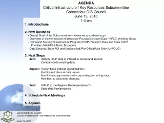
AGENDA Critical Infrastructure / Key Resources Subcommittee Connecticut GIS Council June 15, 2010 1-3 pm • 1. Introductions • 2. New Business • - Overall Goal of the Subcommittee – where we are, where to go • - Overview of the Homeland Infrastructure Foundation-Level Data (HIFLD) Working Group • - Homeland Security Infrastructure Program (HSIP) Freedom Data and State CI/KR Priorities; NGA/TGS Data; Taxonomy • - Data Security: State FOI and Unclassified//For Official Use Only (U//FOUO) • 3. Next Steps • July: Identify HSIP data of interest to review and assess; • Comparison to existing data. • August: Report back findings (good/bad/etc.) • Identify and discuss data issues; • Identify best approaches to incorporating/correcting data; • How best to document changes. • Sept: HIFLD to the Regions Representative (?) • State data flow/protocols • 4. Schedule Next Meetings • 5. Adjourn
Overall Goal of the Subcommittee – where we are, where to go Within the Data Inventory and Assessment Working Group, individual subcommittees are tasked to evaluate, document and provide recommendations for each framework dataset, and establish policies, standards and general procedures for the submission, evaluation, maintenance, on-line access, and dissemination of all geospatial data within the purview of the Council. Mission: The mission of the Critical Infrastructure and Key Resources (CI/KR) Framework Data Subcommittee is to inventory and assess CI/KR GIS information, develop data standards and maintenance protocols, and to coordinate with all key parties at the federal, state, and local government levels and public utilities. The Goal: The ultimate goal is to have the best available and robust CI/KR datasets to populate the State Geographic Emergency Management System (GEMS) application and support emergency management.
Overall Goal of the Subcommittee – where we are, where to go December 2008 • Subcommittee “adopted” the 18 CI/KR Sectors based on DHS • Identified existing GIS data layers, wish-list data layers, and general information about • the data. • Prioritized data layers within each of the sectors • Identified “Data Stewards” and “Sector Stewards” • General task was to obtain data where possible or at least know where it is and the • general quality of the data.
Overall Goal of the Subcommittee – where we are, where to go
We focused on working with TGS, NGA’s contractor, to develop new datasets for the • state, which in turn would be given to Feds and be part of the HSIP Freedom data. Fire Stations Correctional Facilities EMS Stations Law Enforcement Hospitals Places of Worship Nursing Homes Public Health Departments Overall Goal of the Subcommittee – where we are, where to go 2009 • 2009 was a sabbatical year……kind of
2010-2011 Where To Go • Coordinate with Homeland Infrastructure Foundation-Level Data (HIFLD) Working • Group • Utilize Homeland Security Infrastructure Program (HSIP) Freedom Data to “fill in the • gaps” for Connecticut's priorities and needs. • Push data back up to make HSIP Freedom better. Overall Goal of the Subcommittee – where we are, where to go 2009-2010 Where We Are Now • Needed to develop a different approach • Need to leverage existing federal data, standards, initiatives, etc. to augment our • efforts/goals due to our limited staff resources Discussion?
Foreign Threat Critical Infrastructure Protection Domestic Threat Why HIFLD Started • Needed to fuse, analyze and visualize information – everything has a location • Maps for decision makers were wrong • PowerPoint Clip Art was default map of U.S. • Needed a common geospatial foundation for multiple Homeland Defense/Homeland Security (HD/HLS) uses • Needed partnerships to accomplish
The HIFLD Working Group works within DoD, DHS and among their Homeland Defense and Homeland Security partners to promote domestic infrastructure geospatial information gathering, sharing and protection, visualization, and spatial knowledge management. Imagery Terrain Elevation Data Geodetic Data Topographic Data Aeronautical Data HIFLD Objective Hydrographic Data Operational Geospatial Data Foundation Infrastructure Data Geospatial Intelligence
Unified homeland infrastructure foundational geospatial data inventory assembled by NGA in partnership with DoD, DHS and USGS for use by the HD/HLS Communities Compilation of best available Federal government and commercial proprietary data sets Web Dissemination Foundation Data in: Palanterra, iCAV National Operations Center, iDomain, SAGE, Triton, HD Maps, SMADS, and others Originally, for Federal use only; commercial licenses now extended to include disclosure to states and local governments and dissemination during Federal disasters HIFLD Community works to continuously improve by identifying authoritative and value-added data layers HSIP Gold – Foundation Data
Federal Reserves Major Dams High Voltage Transmission Sports Complexes Pipelines NGA holds geospatial datasets over the US Over 11 million records and 340 Feature Classes
Requirement for increased and sustained collaboration expressed by: National State Geospatial Information Council (NSGIC) National Association of Counties (NACo) Infrastructure information required prior to incidents for training and planning to enhance preparedness, response, and recovery Extend awareness and reach of Federal Infrastructure Protection resources Strengthen Federal – State – Private Sector Partnerships We are doing this on the protection and security fronts. Focus on Data and GIS interaction and collaboration Savings of $Ms spent on commercial data Regional HIFLD Mission Requirement
Partnerships (w/ data and GIS counterparts at the S&L level) Critical component for true data integration and exposing data services Critical to coordinated remote sensing operations Enhanced Data Management – Requirements, Access and Information Sharing, Collection, Standards, Protection Help level the playing field between States and Counties with and without resources to leverage infrastructure data for their Infrastructure Protection programs Accelerate build of HSIP Freedom (Federally acquired data provided to S&L gov.) Increased data population of the Infrastructure Data Warehouse Increased coordinated preparedness and situation awareness down to the County level Mission Gap
Personnel Requirements • National HIFLD – 1 • Regional IEBs – 16 • GIS/A for PSAs – 8
Phase I-III: Complete Phase IV Alpha: Information Gathering (Store in Geodatabase/Shapefile) Identify Federal Sponsors (DHS/IICD, DCIP, ISE PM) / Leads for each Area (PSA) Prioritize PSA Areas for implementation based on resources (2-3 initially) Identify PSA Area Participants and Collect Contact Information Identify Regional / State Meetings that already exists – LEVERAGE Identify Regional Staffing Phase IV Bravo: Layout Regional Meeting Schedule Layout Regional Themes and Venues Layout Initial Agendas (common thread – infrastructure data and GIS support to IP) From FEDs: HSPD-7, NIPP, DCIP, HSIP Freedom/Gold, PPWG, FEMA, EPA, FGDC HLS, GIS Inventory, DISDI, NORTHCOM, Remote Sensing Capabilities, GDM, FEMA MapMod, NOAA Coastal Data Applications / Models: iCav, DHS Earth, ACAMs, SAGE, BZPPs, IST, CAPTAP From Regions: State Organizations, Projects, Geospatial Data Efforts; Requirements Gathering and Data Collection, Data Sharing Effort Evolve into Data and GIS Technology Integration Activities Data / Geospatial Resource website for each PSA Area on HIFLD website Remote sensing coordination, integration, and leveraging Regional HIFLD Data (HSIP Gold and Freedom) Feedback Mechanism Integrate Webinars, VTCs, Lessons Learned, Data Collection Strategies / Implementation Plans HIFLD Phased Implementation
DHS Infrastructure Taxonomy • For critical infrastructure, it is important to use a consistent terminology to facilitate communication and dissemination of information. Critical infrastructure and their elements can be described and categorized in various ways. To alleviate information sharing issues, DHS has developed the Infrastructure Taxonomy to serve as the standard for naming CIKR. • This document outlines the taxonomy used by DHS to categorize various infrastructure elements. • To the extent possible, the terminology is representative of each industry. • The taxonomy merely defines the mutually exclusive categories to outline all infrastructure types within a given sector.
Data Security: State FOI and Federal Unclassified//For Official Use Only (U//FOUO) ADVISORY BULLETIN 2008-2 Issued May 19, 2008 As of October 1, 2007, if the FOI request comes to a municipal, district or regional agency, and the agency wishes to withhold all or part of the requested records based on §1-210(b)(19) and/or §1-210(d), the chief executive officer of such agency must request a determination of the reasonable grounds for a safety risk from the Commissioner of the state Department of Emergency Management and Homeland Security. If the FOI request comes to a state executive branch agency, the safety risk determination must be requested from the state Department of Public Works (DPW).
Data Security: State FOI and Federal Unclassified//For Official Use Only (U//FOUO) HSIP Freedom data set is deemed For Official Use Only (FOUO), therefore, it is not open to the public at this time. Non-licensedData Access and Use: Databases contained in HSIP Gold 2010 have varied data access and use constraints, which are documented in each individual dataset’s metadata. The major categories for access are: None (Public Domain Information); Federal, State and Local Government and Industry Partner Access Only; Federal, State and Local Government Access Only; Federal Government Access Only
Next Steps Meeting 2: Identify HSIP data of interest to review and assess How does it compare to existing sector data Meeting 3: Report back findings (good/bad/etc.) Identify and discuss data issues Identify best approaches to incorporating/correcting data How best to document changes Meeting 4: HIFLD to the Regions Representative (?) State data flow/protocols Changes? Suggestions?
Schedule Next Meetings ~end~