Download
1 / 28
280 likes | 310 Vues
Visual Analysis and Semantic Exploration of Urban LIDAR Change Detection. Thomas Butkiewicz, Remco Chang, Zachary Wartell, and William Ribarsky. Project Goals: Develop change detection algorithm Urban areas (new buildings, construction, etc) County-wide, annual LIDAR scans

E N D
Visual Analysis and Semantic Exploration ofUrban LIDAR Change Detection Thomas Butkiewicz, Remco Chang, Zachary Wartell, and William Ribarsky
Project Goals: • Develop change detection algorithm • Urban areas (new buildings, construction, etc) • County-wide, annual LIDAR scans • Interactive exploration Target Users: • Urban planners • Historians • Tax Enforcement
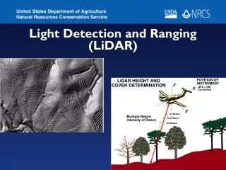
Airborne LIDAR: Laser Rangefinder + GPS/Inertial Navigation Sample Points (x,y,z) w or w/o classification Tens of thousands of point/second
Previous Work Many previous approaches interpolate to rasters: Interpolation 3D point cloud 2D grid of heights Reduces accuracy Points no longer measurements Fails to exploit areas of higher density Vu T., Matsuoka M., Yamazaki F. Lidar-based change detection of buildings in dense urban areas. In Proceedings of IEEE Geoscience and Remote Sensing Symposium, 2004. vol. 5, pp. 3413–3416.
Previous Work Grids/Rasters than subtracted Scan 1 - Scan 2 = Difference Change Extraction done on the 2D grid of height differences Thresholding Vu T., Matsuoka M., Yamazaki F. Lidar-based change detection of buildings in dense urban areas. In Proceedings of IEEE Geoscience and Remote Sensing Symposium, 2004. vol. 5, pp. 3413–3416.
Previous Work Filtering of changes done with image processing Original Opened Opened then Closed Coarse control of filtering due to granularity of kernel sizes Creates false silhouettes/footprints Loss of detail 3x3 5x5 7x7
Change Detection Differences in our technique: Points tested individually (No interpolation) Accuracy preserved Variable density exploited Reliable measurements 3D, shape-based filtering Finer granularity More options (size, height, area, shape, semantical)
Change Detection Input: X,Y,Z points Decision: Does this point fit the existing model? Change due to measurement? or Change in physical environment? Output: Only theX,Y,Z points that represent changes (To change aggregator)
Change Detection All possible surfaces Sampled Points Triangle Network "Analyzing Sampled Terrain Volumetrically with Regard to Error and Geologic Variation“ Thomas Butkiewicz, Remco Chang, Zachary Wartell, William Ribarsky Proc. SPIE Visualization and Data Analysis 2007, San Jose, CA
Change Aggregation Input: X,Y,ZChange points (From change detector) Task: Attempt to assemble nearby points into cohesive models. Output: Change Models (Exported for the Interactive Application)
Change Aggregation Unvisited marked (as changed) vertices: Has marked neighobrs? No – discard (lone point street sign, power line, etc) Yes – Add incident faces to model, visit neighbors
Change Aggregation Input: Change Points Output: Change Models
Interactive Exploration Raster based methods: Results are 2D images This is boring and offers no insight or interactivity! Murakami H., Nakagawa K., Hasegawa H., Shibata T., Iwanami E.: Change detection of buildings using an airborne laser scanner. Journal of Photogrammetry and Remote Sensing 54 (July 1999), 148–152. Vu T., Matsuoka M., Yamazaki F. Lidar-based change detection of buildings in dense urban areas. In Proceedings of IEEE Geoscience and Remote Sensing Symposium, 2004. vol. 5, pp. 3413–3416.
Interactive Exploration Features: 3D GIS Environment GIS Database Integration Interactive Filtering Tools Analytical Tools
GIS Integration Other Data: Building permits, Tax Database, etc Vector Data: Roads, Building Footprints, etc
Non-Realistic Level-of-Detail Traditionally: Popping or fade out Zooming out… Buildings 1 pixel disappear NR LOD Solution: No popping Seamless transition Cognitively correct presentation: “What abstraction makes sense to show at each extent?” Distance away Regions of Changes Groups of Changes Individual Changes
Regional Level Legible Simplification of Textured Urban Models Remco Chang, Thomas Butkiewicz, Caroline Ziemkiewicz, Zachary Wartell, Nancy Pollard, William Ribarsky IEEE Computer Graphics and Applications (CG&A) Issue on Procedural Methods for Urban Modeling.
Discussion and Future Work Additional uses: FEMA floodplain mapping Live battlefield change detection* Future enhancements: LIDAR classification data Aerial photos + obliques SAR (penetrability) Automatic target recognition * Visual Analysis for Live LIDAR Battlefield Change Detection. Thomas Butkiewicz, Remco Chang, Zachary Wartell, William Ribarsky. SPIE Defense and Security Symposium 2008.
Conclusions We have developed: A method for comparing LIDAR data that: Preserves accuracy Results in useful 3D change models An interactive application for exploring the detected changes, which has: Intuitive presentation of changes Non-realistic LOD for scale-appropriate data abstraction Analytical and Filtering tools