Download
1 / 30
300 likes | 490 Vues
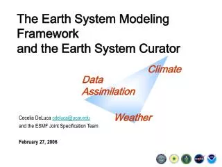
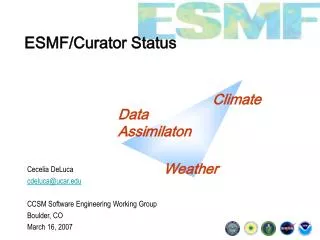
Update on ESMF, Earth System Curator, and Earth System CoG. Cecelia DeLuca and the ESMF team CCSM Software Engineering Working Group June 23, 2011. Outline. NESII Overview NESII Projects Earth System Modeling Framework (ESMF) National Unified Operational Prediction Capability (NUOPC)

E N D
Update on ESMF, Earth System Curator, and Earth System CoG Cecelia DeLuca and the ESMF team CCSM Software Engineering Working Group June 23, 2011
Outline • NESII Overview • NESII Projects • Earth System Modeling Framework (ESMF) • National Unified Operational Prediction Capability (NUOPC) • Earth System Curator • Earth System Commodity Governance (CoG) • Curator Hydrology • NOAA Climate Projection Pilot (NCPP) • TeraGrid Environmental Science Gateway • Global Interoperability Program
The Vision • Develop interoperable modeling components that can connect in multiple waysImprove predictions and support research • Build advanced utilities that many models can useEnable research, promote efficiency • Enable models to be self-describingIncrease understanding and defensibility of outputs • Create workflows that automate the modeling process from beginning to endImprove productivity • Build workspaces that encourage collaborative, distributed development of models and data analysisLeverage distributed expertise
The Team NESII visitors:Tony Wong, intern and Jay Hnilo, NCDC
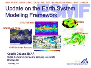
Earth System Modeling Framework Started: 2002 Collaborators: Co-developed and used by NASA (GEOS-5 climate model), NOAA (NCEP weather models), Navy (global and regional models), Community Earth System Model, others Sponsors: NASA MAP, NOAA NWS and CPO, NSF SEIII, DoD HPCMP • ESMF increases code reuse and interoperability in climate, weather, coastal and other Earth system models • ESMF is based on the idea of components, sections of code that are wrapped in standard calling interfaces
ESMF as anInformation Layer • Parallel generation and application of interpolation weights • Run-time compliance checking of metadata and time behavior • Fast parallel I/O (PIO from NCAR/DOE) • Redistribution and other parallel communications • Automated documentation of models and simulations (new) • Ability to run components in workflows and as web services (new) Applications of information layer Structured model information stored in ESMF wrappers Attributes: CF conventions, ISO standards, METAFOR Common Information Model Standard metadata ESMF data structures Standard data structures Component Field Grid Clock User data is referenced or copied into ESMF structures Native model data structures modules grids timekeeping fields
ESMF Regridding Fully parallel, portable Working towards CF compliance for structured and unstructured grid formats Two ways to invoke regridding: • ESMF Offline: • Application which can be automatically built as part of ESMF • Application generates a netCDF weight file from two netCDF grid files • Supports SCRIP format grid files, and a custom ESMF unstructured format mpirun –np 32 ESMF_RegridWeightGen –s src_grid.nc –d dst_grid.nc –m bilinear –w weights.nc • Integrated: • ESMF library subroutine calls which do interpolation during model run • Can get weights or feed directly into ESMF parallel sparse matrix multiply • Can be used without ESMF components call ESMF_FieldRegridStore(srcField=src, dstField=dst, regridMethod=ESMF_REGRID_METHOD_BILINEAR, routehandle=rh) call ESMF_FieldRegrid(srcField=src, dstField=dst, routehandle=rh)
ESMF Offline Supported Grids RESULT: “use of the parallel ESMF offline regridding capability has reduced the time it takes to create CLM surface datasets from hours to minutes” - Mariana Vertenstein, NCAR • Grids with spherical (lon, lat) coordinates – any pair of: • Global 2D logically rectangular grids • Regional 2D logically rectangular grids • 2D unstructured meshes composed of polygons with any number of sides: triangles, quadrilaterals, pentagons, hexagons,… • Multi-patch grids (e.g. cubed spheres) currently supported via unstructured format HOMME Cubed Sphere Grid with Pentagons Courtesy Mark Taylor of Sandia Regional Grid FIM Unstructured Grid Courtesy ESRL GSD
Integrated Supported Grids In addition, integrated regridding supports Cartesian (x,y) coordinates: • Regridding between any pair of: • 2D meshes composed of triangles and quadrilaterals • 2D logically rectangular Grids composed of a single patch • Bilinear regridding between any pair of: • 3D meshes composed of hexahedrons • 3D logically rectangular Grids composed of a single patch 2D Unstructured Mesh From www.ngdc.noaa.gov 3D Grid 3D Unstructured Mesh
ESMF OfflineRegrid Use Enable CLM land model to run on any ustructured grid Grids: Land lat/lon grid to unstructured grid including HOMME cubed sphere ESMF parallel bilinear mapping from lat/lon to HOMME cubed sphere allowed investigation of high resolution land model to move forward for CESM Reduce noise in interpolated wind stress values Grids: CAM atmosphere lat/lon to POP ocean displaced pole lat/lon ESMF patch interpolation reduced imprint of coarser resolution atmosphere grid on ocean for interpolated wind stress values. Enable interpolation of POP ocean and HOMME Grids: HOMME cubed sphere atmosphere to POP ocean grid ESMF conservative regridding enabled integration of a high resolution dynamical core into CAM, reduced distortion near the pole Improve pole treatment for geodesic to lat/lon remapping Grids: MPAS unstructured grid to POP ocean grid ESMF conservative interpolation solved problems with negative weights at the pole Also: geodesic to geodesic and other interpolation for CSU is working, NCL
National Unified Operational Prediction Capability (NUOPC) Started: 2010 Collaborators: Tri-agency (NOAA, Navy, Air Force) consortium of operational weather prediction centers, with participation from NOAA GFDL and NASA modelers Sponsors: NOAA NWS and Navy • ESMF allows for many levels of components, types of components, and types of connections • In order to achieve greater interoperability, usage and content conventions and component templates are needed • This collaboration is building a “NUOPC Layer” that constrains how ESMF is used, and introduces metadata and other content standards • The initial pilot project (to be delivered June 2011) focuses on atmosphere-ocean coupling in NCEP NEMS and Navy NOGAPS and COAMPS codes
A Common Model Architecture NUOPC partners have agreed on a subset of components whose interactions will be standardized
Establish an architecture in which major components are siblings. The initial design supports explicit coupling and concurrent or sequential execution of components. Allow inheritance from generic component templates. Couple components with pre-fabricated connectors. Standardize the number and function of phases of initialize, creating a standard setup pattern. Constrain the data that may be sent between components with standardized field data structures and a CF-based field dictionary. Implement a compliance checker to provide feedback during component development. Use compatibility checking to determine if required import fields for a component were supplied. Other run-time reporting alerts users to any issues with compliance. NUOPC Layer prototype
Component templates and generic connectors make it easier for modelers to create compliant systems since they can reuse existing code and patterns Constraining and clearly defining initialize phases ensures that components fit into standard drivers. Constraining Field data structures and metadata ensures that the data communicated between components is understood The ESMF layer ensures that components fit together into an executable application. Detailed reporting provides the model developer with the insight necessary to debug and rectify code quickly. Interoperability impact
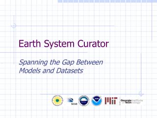
Earth System Curator Started: 2005 Collaborators: METAFOR , NCAR, DOE PCMDI, Earth System Grid Federation, NOAA GFDL, Georgia Institute of Technology Sponsors: NSF SEIII, NASA MAP, NOAA GIP • Intergovernmental Panel on Climate Change (IPCC) assessments rely on data generated by Coupled Model Intercomparison Projects (CMIPS), where different scenarios are tested across many models • For the last IPCC assessment, there was little metadata available about the runs performed • The Curator project collaborated on a comprehensive metadata schema for climate models, and implemented a metadata display in the Earth System Grid data distribution portal
ESG Metadata Display This screen shot shows a real CMIP5 run as it appears in an ESGF portal RESULT: MUCH more information about climate models used in assessments, in browsable, searchable form
Earth System CoG Started: 2009 Collaborators: NCAR, Eart System Grid Federation, University of Michigan, CU Community Surface Dynamics Modeling System Sponsors: NSF CDI • Project hosting and indexing with connections to data and analysis services through the Earth System Grid Federation (ESGF) • Workspaces for collaborative model building, evaluation and analysis • Templates for project layout so information is easy to find • Peer or parent/child connections between projects • Multiple modes of communications between projects (e.g. broadcast news to all children) • Pilot project is 2012 workshop on comparison of atmospheric dynamical cores (previously supported 2008 workshop)
2008 Dynamical Core Colloquium on CoG CoG prototype includes data search, wikis, and communications NEXT: Users will be able to save ESGF datasets, LAS analysis and visualizations and other artifacts back to the workspace
Curator Hydrology Started: 2009 Collaborators: University of South Carolina, University of Michigan Sponsors: NOAA GIP • A new perspective on climate impacts modeling • Instead of what do we “put in” the climate model … • How do we create a linked network of models that multiple communities can use?
Climate-Hydro Coupling • Hydrological impact studies can be improved when forced with data from climate models [Zeng et al., 2003; Yong et al., 2009] • Ideally the coupling would be two-way • A technology gap exists: • Many hydrological models run on personal computers • Most climate models run on high performance supercomputers • Existing frameworks: ESMF (climate/weather) and OpenMI (hydrology) can connect these types of models • ESMF and OpenMI components can be operated as web services that can be used to communicate across a distributed network • Both ESMF and OpenMI are widely used
Prototype Climate-Hydro System Personal Computer • SWAT (hydrology model) runs on PC • CAM (atmospheric model) runs on HPC • Wrappers for both SWAT and CAM provide OpenMI interface to each model • Driver (OpenMI Configuration Editor) uses OpenMI interface to timestep through models via wrappers Driver OpenMI SWAT CAM OpenMI Wrapper • Access to CAM across the network provided by ESMF Web Services • CAM output data written to NetCDF files and streamed to CAM wrapper via ESMF Web Services • Using prototype to explore feasibility of 2-way coupling High Performance Computer Data Files ESMF Web Services ESMF CAM Component From Saint, iEMSs 2010
Target Coupled System • Target system informed by exploration of parameter space for different strategies (estimated SWAT and CAM run times and transfer times) • SWAT covering southeast U.S. coupled to CAM/CLM – purple region • Restricting finest SWAT resolution to watersheds of interest (Neuse and Savannah) makes calibration somewhat easier • SWAT forced by CAM fields (precip, temperature, wind speed, etc.); ET from SWAT nudges values in CAM
TeraGrid Environmental Science Gateway Started: 2008 Collaborators: NCAR CISL and CESM, Purdue University Sponsors: NSF TeraGrid • Creates an end-to-end, self-documenting workflow for running the Community Earth System Model (CESM) • GUI configuration and submission of runs through the Purdue CESM portal • ESMF is used within CESM to organize and output extensive model metadata • Data and metadata is archived back to an Earth System Grid Federation Gateway, where it can be searched and browsed • Currently have a working prototype
CESM portal ESG gateway Gateway Architecture User requests Account DB Token Mgr TG MyProxy CESM Web Services Data/ Metadata Track Status Create Case Configure Case Submit Case Authentication/ Authorization Transfer Files Job Management Debugging Post-process Publish Data Publish Metadata Output Output Jobs ESG Data Publisher Scratch Storage iRODS
NOAA Global Interoperability Program Started: 2009 Collaborators: NOAA GFDL, PMEL, GSD, and NCDC, Unidata, NCAR, CSU, University of Michigan Sponsors: NOAA CPO • GIP builds software infrastructure that • can be used in the weather, water, and climate disciplines, and for training modelers • integrates and automates workflows • NESII lead DeLuca coordinates the project
Building Across Disciplines coordination coordination RESULT: Better coordination of infrastructure development across disparate groups
The Vision • Develop interoperable modeling components that can connect in multiple waysImprove predictions and support research • Build advanced utilities that many models can useEnable research, promote efficiency • Enable models to be self-describingIncrease understanding and defensibility of outputs • Create workflows that automate the modeling process from beginning to endImprove productivity • Build workspaces that encourage collaborative, distributed development of models and data analysisLeverage distributed expertise
Questions? • For more information, links and references, see our newish group page: http://esrl.noaa.gov/nesii/