Download
1 / 5
50 likes | 154 Vues
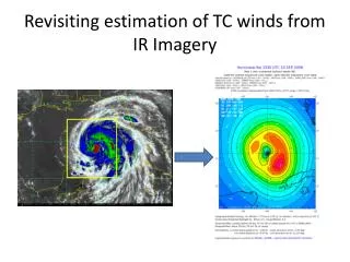
This study revisits the methodology for estimating tropical cyclone winds using IR imagery. By analyzing aircraft data on a polar grid and decomposing it into wavenumbers 0, 1, and 2, as well as IR images into 2-D principle components, we aim to improve wind estimation accuracy. The approach involves applying surface reduction methods and extrapolating wavenumber amplitudes to the 500km region of the cyclone vortex. Additionally, we factor in translation speed, intensity, and other parameters to enhance the accuracy of surface wind speed estimates. The methodology is illustrated using Hurricane Ike as an example, showcasing 3-hourly wind estimates from September 10, 2008, at 18 UTC.

E N D
Making sense of the data Data and documentation Analyses Analyze aircraft data on a polar grid, motion relative Apply surface reduction Decompose into wavenumber 0, 1, and 2 Analyze IR images on a polar grid, motion relative Decompose into 2-D principle components • Flight-level data (1995-2012) • Estimates of tangential wind at the 500km radius (GFS) • IR images (3-hourly here) • Best track (intensity, motion) • Methods to estimate surface inflow angles • Methods to reduce winds from flight-level to the surface
Method • Single-field principle component analysis (SFPCA; Bretherton et al. 1992) applied to the amplitude and phase of the wind field • This relates intensity, latitude, translation speed, and the IR principle components to the surface wind speeds • Extrapolate the Amplitudes of wavenumbers through the 166km to 500km region of the vortex • Apply inflow angles that are a function of translation speed, intensity, radius, and the radius of maximum wind (Zhang and Uhlhorn 2012)